Country:
 USA
USARegion:
City:
Latitude and Longitude:
Time Zone:
Postal Code:
IP information under different IP Channel
ip-api
Country
Region
City
ASN
Time Zone
ISP
Blacklist
Proxy
Latitude
Longitude
Postal
Route
IPinfo
Country
Region
City
ASN
Time Zone
ISP
Blacklist
Proxy
Latitude
Longitude
Postal
Route
MaxMind
Country
Region
City
ASN
Time Zone
ISP
Blacklist
Proxy
Latitude
Longitude
Postal
Route
Luminati
Country
USRegion
nj
City
jerseycity
ASN
Time Zone
America/New_York
ISP
Mercury Telecom LLC
Latitude
Longitude
Postal
db-ip
Country
Region
City
ASN
Time Zone
ISP
Blacklist
Proxy
Latitude
Longitude
Postal
Route
ipdata
Country
Region
City
ASN
Time Zone
ISP
Blacklist
Proxy
Latitude
Longitude
Postal
Route
Popular places and events near this IP address

2nd Street station (Hudson–Bergen Light Rail)
Distance: Approx. 603 meters
Latitude and longitude: 40.7416,-74.0428
2nd Street station is a station on the Hudson–Bergen Light Rail (HBLR) located west of Marshall Street near the foot of Paterson Plank Road in Hoboken, New Jersey. There are two tracks and two side platforms.
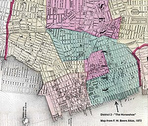
Horseshoe, Jersey City
Populated place in Hudson County, New Jersey, US
Distance: Approx. 575 meters
Latitude and longitude: 40.731039,-74.042026
The Horseshoe section of Jersey City, New Jersey, was the second ward, and was the home of the immigrants, tenements, and taverns. The Republican-controlled Legislature gerrymandered the district in 1871 to concentrate and isolate Democratic, and mostly Catholic, votes, thus preserving Republican dominance in the rest of the city. The curved shape of the district was said to resemble a horseshoe.

The Village, Jersey City
Populated place in Hudson County, New Jersey, US
Distance: Approx. 316 meters
Latitude and longitude: 40.7338,-74.0442
The Village is a neighborhood in the western section of Historic Downtown in Jersey City. It is bordered by Hamilton Park and Harsimus Cove to the east and the Turnpike Extension to the west, on the other side of which Jones Park and Mary Benson Park are located. Newark Avenue is the major street across the Village from Grove Street at the east to Bergen Hill at the west.
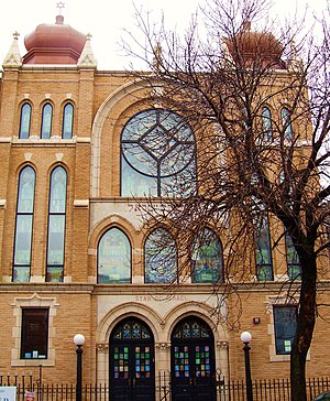
United Synagogue of Hoboken
Distance: Approx. 776 meters
Latitude and longitude: 40.73805556,-74.03333333
The United Synagogue of Hoboken is a Conservative synagogue in Hoboken, Hudson County, New Jersey, in the United States.

Keuffel and Esser Manufacturing Complex
United States historic place
Distance: Approx. 728 meters
Latitude and longitude: 40.74138889,-74.03694444
The Keuffel and Esser Manufacturing Complex is located in Hoboken, Hudson County, New Jersey, United States. The western concrete building with the four-sided clock tower was built in 1906 and opened in 1907, after the previous building was destroyed by a fire in 1905. Keuffel and Esser manufactured instruments for the architectural, engineering and drafting professions at the complex from 1907 to 1968.
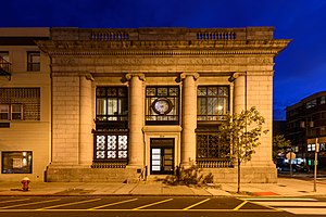
Jefferson Trust Company
United States historic place
Distance: Approx. 619 meters
Latitude and longitude: 40.73805556,-74.03527778
The Jefferson Trust Company is a historic building located in Hoboken, Hudson County, New Jersey, United States. The building was built in 1912 and was added to the National Register of Historic Places on February 13, 1986. The original trust company failed during the Great Depression and the building passed on to a succession of owners.

Pohlmann's Hall
United States historic place
Distance: Approx. 498 meters
Latitude and longitude: 40.73972222,-74.04583333
Pohlmann's Hall is a building located in Jersey City, Hudson County, New Jersey, United States. The building was added to the National Register of Historic Places on September 5, 1985.

Engine Company No. 3
United States historic place
Distance: Approx. 623 meters
Latitude and longitude: 40.74083333,-74.03805556
Engine Company No. 3 is located in Hoboken, Hudson County, New Jersey, United States. The firehouse was designed by Fagan & Briscoe and was built in 1915.

Engine House No. 3, Truck No. 2
United States historic place
Distance: Approx. 247 meters
Latitude and longitude: 40.73694444,-74.03944444
Engine Company No. 3 is located in Hoboken, Hudson County, New Jersey, United States. The firehouse was designed by Charles Fall and was built in 1892.

Engine Company No. 4
United States historic place
Distance: Approx. 824 meters
Latitude and longitude: 40.73972222,-74.03361111
Engine Company No. 4 is located in Hoboken, Hudson County, New Jersey, United States. The firehouse was designed by Francis G. Himpler and was built in 1870.

Christ Hospital (Jersey City, New Jersey)
Hospital in New Jersey, U.S.
Distance: Approx. 821 meters
Latitude and longitude: 40.7333,-74.05115
Christ Hospital is in Jersey City, New Jersey. It is affiliated with Hoboken University Medical Center and the Bayonne Medical Center. It is one of the six hospitals in Hudson County, New Jersey operated by the for-profit organization Hudson Hospital Opco, known as Care Point Health.
Cucharamama
Defunct restaurant in Hoboken, New Jersey, U.S.
Distance: Approx. 818 meters
Latitude and longitude: 40.740692,-74.034522
Cucharamama was a restaurant in Hoboken, New Jersey.
Weather in this IP's area
clear sky
22 Celsius
22 Celsius
20 Celsius
23 Celsius
1027 hPa
63 %
1027 hPa
1027 hPa
10000 meters
6.17 m/s
40 degree
06:38:18
19:03:36