176.116.26.3 - IP Lookup: Free IP Address Lookup, Postal Code Lookup, IP Location Lookup, IP ASN, Public IP
Country:
 France
Region:
City:
Location:
Time Zone:
Postal Code:
ISP:
ASN:
language:
User-Agent:
Proxy IP:
Blacklist:
IP information under different IP Channel
ip-api
Country
Region
City
ASN
Time Zone
ISP
Blacklist
Proxy
Latitude
Longitude
Postal
Route
db-ip
Country
Region
City
ASN
Time Zone
ISP
Blacklist
Proxy
Latitude
Longitude
Postal
Route
IPinfo
Country
Region
City
ASN
Time Zone
ISP
Blacklist
Proxy
Latitude
Longitude
Postal
Route
IP2Location
176.116.26.3Country
frRegion
hauts-de-france
City
albert
Time Zone
Europe/Paris
ISP
Language
User-Agent
Latitude
Longitude
Postal
ipdata
Country
Region
City
ASN
Time Zone
ISP
Blacklist
Proxy
Latitude
Longitude
Postal
Route
Popular places and events near this IP address
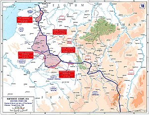
German spring offensive
WWI military offensive along the Western Front
Distance: Approx. 245 meters
Latitude and longitude: 50.00277778,2.65277778
The German spring offensive, also known as Kaiserschlacht ("Kaiser's Battle") or the Ludendorff offensive, was a series of German attacks along the Western Front during the First World War, beginning on 21 March 1918. Following American entry into the war in April 1917, the Germans decided that their only remaining chance of victory was to defeat the Allies before the United States could ship soldiers across the Atlantic and fully deploy its resources. The German Army had gained a temporary advantage in numbers as nearly 50 divisions had been freed by the Russian defeat and withdrawal from the war with the Treaty of Brest-Litovsk.

Albert, Somme
Commune in Hauts-de-France, France
Distance: Approx. 248 meters
Latitude and longitude: 50.0028,2.6528
Albert (French pronunciation: [albɛʁ] ) is a commune in the Somme department in Hauts-de-France in northern France. It is located about halfway between Amiens and Bapaume.

Aveluy
Commune in Hauts-de-France, France
Distance: Approx. 2655 meters
Latitude and longitude: 50.0242,2.6589
Aveluy (French pronunciation: [avlɥi]) is a commune in the Somme department in Hauts-de-France in northern France.

Méaulte
Commune in Hauts-de-France, France
Distance: Approx. 2197 meters
Latitude and longitude: 49.9822,2.6608
Méaulte (French pronunciation: [meolt]) is a commune in the Somme department in Hauts-de-France in northern France.

Canton of Albert
Canton in Hauts-de-France, France
Distance: Approx. 245 meters
Latitude and longitude: 50.00277778,2.65277778
The Canton of Albert is a canton situated in the department of the Somme and in the Hauts-de-France region of northern France.
Communauté de communes du Pays du Coquelicot
Federation of municipalities in France
Distance: Approx. 123 meters
Latitude and longitude: 50,2.65
The Communauté de communes du Pays du Coquelicot is a communauté de communes in the Somme département and in the Hauts-de-France région of France. Its population is 28,302 (2018).
Spring Offensive order of battle
Distance: Approx. 245 meters
Latitude and longitude: 50.00277778,2.65277778
This is the order of battle for Operation Michael, part of the German Spring Offensive fought from 21 March to 5 April 1918 as one of the main engagements of the First World War. It was fought between mixed French, British and Dominion forces and the German Empire in the Somme region in northern France.
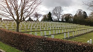
Aveluy Communal Cemetery Extension
WWI CWGC cemetery in Somme, France
Distance: Approx. 2671 meters
Latitude and longitude: 50.0246,2.6568
The Aveluy Communal Cemetery Extension is a cemetery located in the Somme region of France commemorating French and British Commonwealth troops who fought in the Battle of the Somme in World War I. The cemetery honors mainly soldiers who died holding the line near the village of Aveluy from slightly before July 1915 to 26 March 1918.

Bapaume Post Military Cemetery
WWI CWGC cemetery in Somme, France
Distance: Approx. 2020 meters
Latitude and longitude: 50.01157,2.67384
The Bapaume Post Military Cemetery (French: Cimetière militaire de Bapaume Post, Albert) is a cemetery located in the Somme region of France commemorating British and Commonwealth soldiers who fought in the Battle of the Somme in World War I. The cemetery is also known colloquially as the Tara Hill Cemetery and the Usna Hill Cemetery. The cemetery honors mainly those who were killed in the 1 July 1916 attack on the village of La Boiselle, those who died defending the line in the areas east and west of the cemetery, and those who died retaking the village and the surrounding area in August 1918.

Bécourt Military Cemetery
WWI CWGC cemetery in Somme, France
Distance: Approx. 2350 meters
Latitude and longitude: 50.00397,2.68349
The Bécourt Military Cemetery is a cemetery located in the Somme region of France commemorating British and Commonwealth soldiers who fought in the Battle of the Somme in World War I. The cemetery contains those who died in a variety of dates from August 1915 to April 1917 manning the front line near the village of Bécordel-Bécourt and is managed by the Commonwealth War Graves Commission.

Bouzincourt Ridge Cemetery
WWI CWGC cemetery in Somme, France
Distance: Approx. 2545 meters
Latitude and longitude: 50.02197,2.6372
The Bouzincourt Ridge Cemetery is a military cemetery located in the Somme region of France commemorating British and Commonwealth soldiers who fought in World War I. The cemetery contains mainly those who died capturing the village of Bouzincourt between June and August 1918 and those who died on the front line near Bouzincourt.

The Golden Virgin
Sculpture located in Albert, France
Distance: Approx. 380 meters
Latitude and longitude: 50.00375,2.64808333
The Golden Virgin, also known as The Leaning Virgin, is a gilded sculpture by the French artist Albert Roze originally completed in 1897 and installed on the rooftop of the Basilica of Our Lady of Brebières (French: Basilique Notre-Dame de Brebières) in Albert, France. Regarded as a symbol of French resilience during World War I, the artwork portrays the Virgin Mary presenting Christ Child heavenward. In 1915, German shelling knocked over the statue, and it nearly toppled again due to shellfire during the 1916 Battle of the Somme.
Weather in this IP's area
overcast clouds
4 Celsius
-0 Celsius
4 Celsius
4 Celsius
1019 hPa
93 %
1019 hPa
1007 hPa
6000 meters
6.69 m/s
240 degree
100 %