176.113.163.79 - IP Lookup: Free IP Address Lookup, Postal Code Lookup, IP Location Lookup, IP ASN, Public IP
Country:
Region:
City:
Location:
Time Zone:
Postal Code:
ISP:
ASN:
language:
User-Agent:
Proxy IP:
Blacklist:
IP information under different IP Channel
ip-api
Country
Region
City
ASN
Time Zone
ISP
Blacklist
Proxy
Latitude
Longitude
Postal
Route
db-ip
Country
Region
City
ASN
Time Zone
ISP
Blacklist
Proxy
Latitude
Longitude
Postal
Route
IPinfo
Country
Region
City
ASN
Time Zone
ISP
Blacklist
Proxy
Latitude
Longitude
Postal
Route
IP2Location
176.113.163.79Country
Region
kyivska oblast
City
irpin'
Time Zone
Europe/Kiev
ISP
Language
User-Agent
Latitude
Longitude
Postal
ipdata
Country
Region
City
ASN
Time Zone
ISP
Blacklist
Proxy
Latitude
Longitude
Postal
Route
Popular places and events near this IP address

Irpin
City in Kyiv Oblast, Ukraine
Distance: Approx. 573 meters
Latitude and longitude: 50.51666667,30.25
Irpin (Ukrainian: Ірпінь, IPA: [irˈpinʲ] ) is a city on the Irpin River in Bucha Raion, Kyiv Oblast, northern Ukraine. It is located next to the capital Kyiv. Irpin hosts the administration of Irpin urban hromada, one of the hromadas of Ukraine.
Hostomel
Rural locality in Kyiv Oblast, Ukraine
Distance: Approx. 5375 meters
Latitude and longitude: 50.56916667,30.26527778
Hostomel (Ukrainian: Гостомель, IPA: [ɦoˈstɔmelʲ]) is a rural settlement in Bucha Raion, Kyiv Oblast, Ukraine. It is located northwest of the capital Kyiv. It hosts the administration of Hostomel settlement hromada, one of the hromadas of Ukraine.
Bucha, Ukraine
City in Kyiv Oblast, Ukraine
Distance: Approx. 3649 meters
Latitude and longitude: 50.54861111,30.22083333
Bucha (Ukrainian: Буча, pronounced [ˈbutʃɐ] ) is a city in Ukraine's Kyiv Oblast. Administratively, it serves as the administrative center of Bucha Raion. It hosts the administration of Bucha urban hromada, one of the hromadas of Ukraine.
Pushcha-Vodytsia
Neighborhood in Kyiv, Ukraine
Distance: Approx. 7532 meters
Latitude and longitude: 50.54055556,30.35277778
Pushcha-Vodytsia is a historic neighbourhood, climate resort and a former urban-type settlement (1981-2001) in the northwestern part of Kyiv (Obolon Raion). Located within a dense forest and away from the urban Kyiv, it is known for number of sanatoriums and state cottages for government officials such as presidents, prime-ministers etc. The southern border of the neighborhood is considered Hostomelske Highway, the eastern – Minskyi Avenue, the western – the road to the village of Moshchun, Bucha Raion (Kyiv Oblast).
Kotsiubynske
Rural locality in Kyiv Oblast, Ukraine
Distance: Approx. 6934 meters
Latitude and longitude: 50.49,30.33472222
Kotsiubynske (Ukrainian: Коцюбинське) is a rural settlement and municipality in Bucha Raion, Kyiv Oblast (province) of Ukraine. The municipality is an enclave and located outside the borders of Kyiv Oblast, instead fully surrounded by the nation's capital Kyiv (Sviatoshynskyi District). It is the only locality in Kotsiubynske settlement hromada, one of the hromadas of Ukraine.
Vorzel
Rural locality in Kyiv Oblast, Ukraine
Distance: Approx. 7773 meters
Latitude and longitude: 50.55,30.15
Vorzel (Ukrainian: Ворзель) is a rural settlement in Bucha Raion, Kyiv Oblast of Ukraine. It belongs to Bucha urban hromada, one of the hromadas of Ukraine. Population: 6,859 (2022 estimate).
Borshchahivka (river)
River in Ukraine
Distance: Approx. 6047 meters
Latitude and longitude: 50.4675,30.24833333
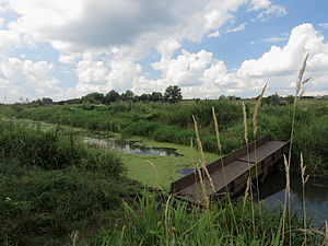
The Borshchahivka is a river in Ukraine, flowing through the city of Kyiv and suburban Bucha Raion of Kyiv Oblast. It is a right tributary of the Irpin in the Dnieper basin.
Battle of Bucha
Engagement in the 2022 invasion of Ukraine
Distance: Approx. 3649 meters
Latitude and longitude: 50.54861111,30.22083333
The battle of Bucha was part of the Kyiv offensive in the Russian invasion of Ukraine for control of the city of Bucha. The combatants were elements of the Russian Armed Forces and Ukrainian Ground Forces. The battle lasted from 27 February to 31 March 2022 and ended with the withdrawal of Russian forces.
Horenka, Bucha Raion, Kyiv Oblast
Village in Kyiv Oblast, Ukraine
Distance: Approx. 6146 meters
Latitude and longitude: 50.556944,30.3175
Horenka (Ukrainian: Горенка; Russian: Горенка) is a village in Bucha Raion (district) in Kyiv Oblast of Ukraine, on the NW border of the city of Kyiv. It belongs to Hostomel settlement hromada, one of the hromadas of Ukraine. Until 18 July 2020, Horenka was located in Kyiv-Sviatoshyn Raion.

Bucha massacre
2022 massacre by Russian forces in Ukraine
Distance: Approx. 3649 meters
Latitude and longitude: 50.54861111,30.22083333
The Bucha massacre (Ukrainian: Бучанська різанина, romanized: Buchanska rizanyna; Russian: Резня в Буче, romanized: Reznya v Buche) was the mass murder of Ukrainian civilians and prisoners of war by the Russian Armed Forces during the fight for and occupation of the city of Bucha as part of the Russian invasion of Ukraine. Photographic and video evidence of the massacre emerged on 1 April 2022 after Russian forces withdrew from the city. According to local authorities, 458 bodies have been recovered from the town, including nine children under the age of 18.
Rokach (river)
River
Distance: Approx. 5508 meters
Latitude and longitude: 50.56666667,30.28333333
Rokach (Ukrainian: Рокач, IPA: [roˈkɑtʃ]) is a river in Ukraine, a left tributary of the Irpin River. It is located in Bucha Raion of Kyiv Oblast. The river is 17 kilometres long, and has a drainage basin of 160 square kilometres.

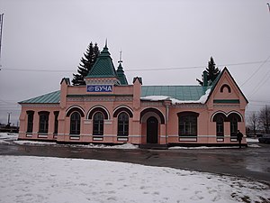
Bucha railway station
Railway station in Bucha, Kyiv Oblast, Ukraine
Distance: Approx. 3652 meters
Latitude and longitude: 50.54888889,30.22138889
Bucha railway station (Ukrainian: Станція Буча) is a railway station in the Ukrainian city of Bucha, and is operated through the Southwestern Railways.
Weather in this IP's area
overcast clouds
6 Celsius
3 Celsius
6 Celsius
6 Celsius
1017 hPa
89 %
1017 hPa
998 hPa
10000 meters
4.43 m/s
10.58 m/s
193 degree
100 %


