Country:
 Germany
Region:
City:
Latitude and Longitude:
Time Zone:
Postal Code:
IP information under different IP Channel
ip-api
Country
Region
City
ASN
Time Zone
ISP
Blacklist
Proxy
Latitude
Longitude
Postal
Route
IPinfo
Country
Region
City
ASN
Time Zone
ISP
Blacklist
Proxy
Latitude
Longitude
Postal
Route
MaxMind
Country
Region
City
ASN
Time Zone
ISP
Blacklist
Proxy
Latitude
Longitude
Postal
Route
Luminati
Country
DEASN
Time Zone
Europe/Berlin
ISP
IBH IT-Service GmbH
Latitude
Longitude
Postal
db-ip
Country
Region
City
ASN
Time Zone
ISP
Blacklist
Proxy
Latitude
Longitude
Postal
Route
ipdata
Country
Region
City
ASN
Time Zone
ISP
Blacklist
Proxy
Latitude
Longitude
Postal
Route
Popular places and events near this IP address

Berlin
Capital and largest city of Germany
Distance: Approx. 0 meters
Latitude and longitude: 52.52,13.405
Berlin is the capital and largest city of Germany, both by area and by population. Its more than 3.85 million inhabitants make it the European Union's most populous city, as measured by population within city limits. The city is also one of the states of Germany, and is the third smallest state in the country in terms of area.

East Berlin
Soviet sector of Berlin between 1948 and 1990
Distance: Approx. 159 meters
Latitude and longitude: 52.51861111,13.40444444
East Berlin (German: Ost-Berlin; pronounced [ˈɔstbɛʁˌliːn] ) was the partially recognised capital of East Germany (GDR) from 1949 to 1990. From 1945, it was the Soviet occupation sector of Berlin. The American, British, and French sectors were known as West Berlin.

AquaDom
Former aquarium in Berlin, Germany
Distance: Approx. 154 meters
Latitude and longitude: 52.51972222,13.40277778
The AquaDom (mixed Latin and German: 'water dome', more formally 'water cathedral') was a 25-metre-tall (82 ft) cylindrical acrylic glass aquarium with built-in transparent elevator inside the lobby of the Radisson Collection Hotel in the DomAquarée complex at Karl-Liebknecht-Straße in Berlin-Mitte, Germany. The DomAquarée complex also contains offices, a museum, a restaurant, and the Berlin Sea Life Centre aquarium. On 16 December 2022, the AquaDom aquarium ruptured, destroying itself and propelling the 1,500 fish inside into nearby facilities and streets, causing considerable damage and killing the majority of the fish.
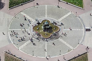
Neptunbrunnen (Berlin)
Distance: Approx. 134 meters
Latitude and longitude: 52.5196,13.40687
The Neptune Fountain (German: Neptunbrunnen) in Berlin was built in 1891 and was designed by Reinhold Begas. The Roman god Neptune is in the center. The four women around him represent the four main rivers of Prussia at the time the fountain was constructed: the Elbe (with the allegorical figure holding fruits and ears of corn), Rhine (fishnet and grapes), Vistula (wooden blocks, symbols of forestry), and Oder (goats and animal skins).

Rosenstrasse protest
1943 street protest in Nazi Germany
Distance: Approx. 204 meters
Latitude and longitude: 52.52180556,13.40444444
The Rosenstrasse protest is considered to be a significant event in German history as it is the only mass public demonstration by Germans in the Third Reich against the deportation of Jews. The protest on Rosenstraße ("Roses street") took place in Berlin during February and March 1943. This demonstration was initiated and sustained by the non-Jewish wives and relatives of Jewish men and Mischlinge, (those of mixed Jewish and Aryan heritage).

Karl-Liebknecht-Straße
Major street in the Berlin Mitte district
Distance: Approx. 216 meters
Latitude and longitude: 52.52138889,13.40722222
Karl-Liebknecht-Straße is a major street in the central Mitte district of the German capital Berlin. It is named after Karl Liebknecht (1871–1919), one of the founders of the Communist Party of Germany. The street connects the Unter den Linden boulevard with the Prenzlauer Allee arterial road leading to the northern city limits.

St. Mary's Church, Berlin
Church in Berlin, Germany
Distance: Approx. 129 meters
Latitude and longitude: 52.52055556,13.40666667
St. Mary's Church, known in German as the Marienkirche or St.-Marien-Kirche, is a church in Berlin, Germany. It is located on Karl-Liebknecht-Straße (formerly Kaiser-Wilhelm-Straße) in central Berlin, near Alexanderplatz.

Marx-Engels Forum
Park in Berlin, Germany
Distance: Approx. 194 meters
Latitude and longitude: 52.51833333,13.40416667
Marx-Engels-Forum is a public park in the central Mitte district of Berlin, the capital of Germany. It is named for Karl Marx and Friedrich Engels, authors of The Communist Manifesto of 1848 and regarded as two of the most influential people in the socialist movement. The park was created by the authorities of the former German Democratic Republic (GDR) in 1986.

Mitte (locality)
Quarter of Berlin in Germany
Distance: Approx. 129 meters
Latitude and longitude: 52.51944444,13.40666667
Mitte (German pronunciation: [ˈmɪtə] ; German for "middle" or "center") is a central section (Ortsteil) of Berlin, Germany, in the eponymous borough (Bezirk) of Mitte. Until 2001, it was itself an autonomous district. Mitte proper comprises the historic center of Old Berlin, with the medieval churches of St.

DDR Museum
Berlin museum about life in East Germany
Distance: Approx. 217 meters
Latitude and longitude: 52.51902778,13.40222222
The DDR Museum is a museum in the centre of Berlin. The museum is located in the former governmental district of East Germany, right on the river Spree, opposite the Berlin Cathedral. The museum is the 11th most visited museum in Berlin.
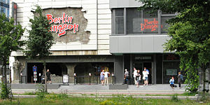
Berlin Dungeon
Distance: Approx. 188 meters
Latitude and longitude: 52.52141,13.40348
Berlin Dungeon is a tourist attraction from a chain including the London Dungeon and Hamburg Dungeon. It provides a journey through Berlin's dark history in an actor led, interactive experience. There are both German and English shows and the actors speak German and English.

Old Synagogue (Berlin)
Former synagogue in Berlin, Germany
Distance: Approx. 123 meters
Latitude and longitude: 52.5211,13.4048
The Old Synagogue (German: Alte Synagoge) was a Jewish congregation and synagogue, that was located at Heidereutergasse 4, in Marienviertel, in the present-day Mitte district of Berlin, Germany. Designed and built by Michael Kemmeter, the synagogue was built as a rectangular hall building. Consecrated in 1714 and remodelled in 1855, the synagogue was known as the Great Synagogue until the opening of the New Synagogue, built in the 1860s to accommodate Berlin's expanding Jewish population.
Weather in this IP's area
broken clouds
17 Celsius
17 Celsius
16 Celsius
17 Celsius
1023 hPa
89 %
1023 hPa
1018 hPa
10000 meters
4.02 m/s
8.05 m/s
19 degree
75 %
06:44:25
19:17:20