176.103.210.237 - IP Lookup: Free IP Address Lookup, Postal Code Lookup, IP Location Lookup, IP ASN, Public IP
Country:
Region:
City:
Location:
Time Zone:
Postal Code:
ISP:
ASN:
language:
User-Agent:
Proxy IP:
Blacklist:
IP information under different IP Channel
ip-api
Country
Region
City
ASN
Time Zone
ISP
Blacklist
Proxy
Latitude
Longitude
Postal
Route
db-ip
Country
Region
City
ASN
Time Zone
ISP
Blacklist
Proxy
Latitude
Longitude
Postal
Route
IPinfo
Country
Region
City
ASN
Time Zone
ISP
Blacklist
Proxy
Latitude
Longitude
Postal
Route
IP2Location
176.103.210.237Country
Region
rostovskaya oblast'
City
aksay
Time Zone
Europe/Moscow
ISP
Language
User-Agent
Latitude
Longitude
Postal
ipdata
Country
Region
City
ASN
Time Zone
ISP
Blacklist
Proxy
Latitude
Longitude
Postal
Route
Popular places and events near this IP address

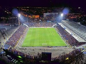
Olimp-2
Football stadium in Rostov-on-Don, Russia
Distance: Approx. 8506 meters
Latitude and longitude: 47.24301111,39.76105278
Olimp-2 (Russian: «Олимп-2», Olympus-2) is a football stadium in Rostov-on-Don, Russia. From 1930 to 2018 it was the home ground of FC Rostov, and in 1958–1970 it was also the home ground of SKA Rostov-on-Don. The stadium opened in 1930 and was known as Rostselmash Plant Stadium until 1996 when it was known as Rostselmash.

Rostov-on-Don Airport
Defunct airport in Russia (1925–2018)
Distance: Approx. 3957 meters
Latitude and longitude: 47.25833333,39.81833333
Rostov-on-Don Airport (IATA: ROV, RVI, ICAO: URRR) was an international airport located 8 kilometres (5 mi) east of the city of Rostov-on-Don, in southern Russia. It was one of the largest airports in the south-west of Russia and the 12th busiest in the country. It was founded in 1925 and was designated an international airport in 1986.

Aksay, Rostov Oblast
Town in Rostov Oblast, Russia
Distance: Approx. 1217 meters
Latitude and longitude: 47.25,39.86666667
Aksay (Russian: Аксай) is a town and the administrative center of Aksaysky District in Rostov Oblast, Russia, located on the right bank of the Don River, 18 kilometers (11 mi) northeast of Rostov-on-Don, the administrative center of the oblast. Population: 41,969 (2010 Census); 38,012 (2002 Census); 33,389 (1989 Soviet census). It was previously known as Ust-Aksayskaya (until 1791), Aksayskaya (until 1957).

Aksaysky District
District in Rostov Oblast, Russia
Distance: Approx. 738 meters
Latitude and longitude: 47.26666667,39.86666667
Aksaysky District, or Aksay Region (Russian: Акса́йский райо́н) is an administrative and municipal district (raion), one of the forty-three in Rostov Oblast, Russia. It is located in the western central part of the oblast. The area of the district is 1,162 square kilometers (449 sq mi).
Shishlovsky Island
Island in Rostov Oblast, Russia
Distance: Approx. 4987 meters
Latitude and longitude: 47.229425,39.91798333
Shishlovskiy Island (Russian: остров Шишловский) is an uninhabited river island in the center of Aksaysky District, Rostov Oblast, Russia. The island is located on the river Don. Length - about 900 meters, width - up to 200 meters.

Flydubai Flight 981
2016 aircraft crash in Rostov-on-Don, Russia
Distance: Approx. 3196 meters
Latitude and longitude: 47.26519444,39.82883333
Flydubai Flight 981 (FZ981/FDB981) was a scheduled international passenger flight from Dubai, United Arab Emirates, to Rostov-on-Don, Russia. On 19 March 2016, the Boeing 737-800 aircraft operating the flight crashed during a go-around, killing all 62 passengers and crew on board. The flight occurred at night and the weather at Rostov-on-Don was poor.
Mukhina Gully
Distance: Approx. 1996 meters
Latitude and longitude: 47.27277778,39.89
Mukhina Gully (Russian: Малый лог, Maly Log) is a protected nature reserve of regional importance, situated in the city of Aksai, Rostov Oblast, Russia. The gully is a steep ravine in the eastern Aksai, the slopes of which are covered with forest. Most of the gully's territory is occupied by swamps.

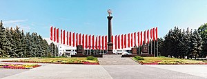
Stele City of Military Glory
Historic site in Rostov Oblast, Russia
Distance: Approx. 5247 meters
Latitude and longitude: 47.25676111,39.801375
Stele “City of Military Glory” is a memorial, located in Pervomaisk district of Rostov-on-don. It is created in commemoration of assignment to the city of the honorary title of the Russian Federation "City of Military Glory". It was inaugurated on May 6, 2010 on the square in front of the airport, which was named ”Square of Military Glory”.
Aksay Bridge
Bridge in Russia
Distance: Approx. 2550 meters
Latitude and longitude: 47.2419,39.8511
The Bridge of Aksay (Russian: Аксайский мост) is a road bridge over the River Don in Rostov-on-Don. Its total span is 580 m (1,900 ft). It was built in 1964 to form part of the 1,062 km (660 mi) M4 "Don" highway, with a two-lane capacity of around 7,000 vehicles per day of up to 6 tonnes per axle.
Aksay customs outpost
Fortress and Museum in Aksay, Rostov oblast Russia
Distance: Approx. 2140 meters
Latitude and longitude: 47.26849,39.89643
The Aksay customs outpost is an earthen fortification construction situated in the Aksay, Rostov region of Russia. It is located on the territory of the former Don Noble estate at the mouth of Small Log Beam. The Czar's outpost was originally built on this territory, followed by a customs post.
Aksay dungeons
Fortress and Museum in Aksay, Rostov oblast Russia
Distance: Approx. 2146 meters
Latitude and longitude: 47.268557,39.896469
Aksay dungeons are dungeons of the town Aksay in Rostov oblast.
Kobyakovo Settlement
Archaeological site in Russia
Distance: Approx. 2161 meters
Latitude and longitude: 47.24638889,39.85111111
The Kobyakovo Settlement (Russian: Кобяково городище) is an archaeological site situated in Rostov Oblast, Russia between the cities of Rostov-on-Don and Aksai.
Weather in this IP's area
overcast clouds
-2 Celsius
-9 Celsius
-2 Celsius
-2 Celsius
1027 hPa
42 %
1027 hPa
1022 hPa
10000 meters
8.2 m/s
17.35 m/s
105 degree
100 %


