Country:
 Netherlands
Region:
City:
Latitude and Longitude:
Time Zone:
Postal Code:
IP information under different IP Channel
ip-api
Country
Region
City
ASN
Time Zone
ISP
Blacklist
Proxy
Latitude
Longitude
Postal
Route
IPinfo
Country
Region
City
ASN
Time Zone
ISP
Blacklist
Proxy
Latitude
Longitude
Postal
Route
MaxMind
Country
Region
City
ASN
Time Zone
ISP
Blacklist
Proxy
Latitude
Longitude
Postal
Route
Luminati
Country
NLRegion
fl
City
almerestad
ASN
Time Zone
Europe/Amsterdam
ISP
CISCOSYSTEMS
Latitude
Longitude
Postal
db-ip
Country
Region
City
ASN
Time Zone
ISP
Blacklist
Proxy
Latitude
Longitude
Postal
Route
ipdata
Country
Region
City
ASN
Time Zone
ISP
Blacklist
Proxy
Latitude
Longitude
Postal
Route
Popular places and events near this IP address
Almere
City and municipality in Flevoland, Netherlands
Distance: Approx. 429 meters
Latitude and longitude: 52.36666667,5.21666667
Almere (Dutch pronunciation: [ɑlˈmeːrə] ) is a planned city and municipality in the province of Flevoland, Netherlands across the IJmeer from Amsterdam. Bordering Lelystad and Zeewolde, the municipality of Almere comprises six official areas that are the districts of Almere Stad (which is further split up into Almere Stad Oost, Almere Stad West and Almere Centrum), Almere Buiten and Almere Pampus (which is currently being designed), and the boroughs of Almere Haven, Almere Hout and Almere Poort. Four of them feature official district or borough offices.

Almere Haven
Borough of Almere in Flevoland, Netherlands
Distance: Approx. 3415 meters
Latitude and longitude: 52.33944444,5.22027778
Almere Haven is the oldest borough of Almere (although the first houses of Almere were built in the neighborhood now known as Oostvaardersdiep in Almere Buiten). Although Almere Haven does not have its own railway station, it is well-connected to Amsterdam and the rest of Almere by a good bus rapid transit system. Almere Haven has a small harbour, as well as a marina and is surrounded by large forests of poplars containing buzzards, foxes, small deer, and owls.
Almere City FC
Association football club in the Netherlands
Distance: Approx. 3321 meters
Latitude and longitude: 52.39444444,5.24055556
Almere City Football Club is a professional football club based in Almere, Netherlands. Founded in 2001, they play in the Eredivisie, the top tier of Dutch football. They host their home matches at the Yanmar Stadion.

Yanmar Stadion
Stadium in Almere, Netherlands
Distance: Approx. 3315 meters
Latitude and longitude: 52.3944,5.2405
Yanmar Stadion (formerly Mitsubishi Forkliftstadion and Almere City Stadion) is a multi-purpose stadium in Almere, Netherlands. The stadium primarily hosts association football matches and is the home ground of Almere City FC. The stadium was built in 2005 with a capacity of 3,000 spectators. In January 2020, the club completed a new grandstand, increasing the capacity to 4,501.

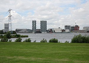
Almere Stad
Borough of Almere in Flevoland, Netherlands
Distance: Approx. 793 meters
Latitude and longitude: 52.37666667,5.21611111
Almere Stad is a district of the city Almere in the Dutch province Flevoland. The first houses in Almere Stad were finished in 1980. Nowadays there are several residential areas, offices, industrial areas, parks, and a lake.
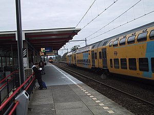
Almere Muziekwijk railway station
Railway station in the Netherlands
Distance: Approx. 1565 meters
Latitude and longitude: 52.3675,5.19027778
Almere Muziekwijk is a railway station in Almere, The Netherlands. It is located approximately 20 km east of Amsterdam. It is on the Weesp–Lelystad railway.

Almere Centrum railway station
Railway station in the Netherlands
Distance: Approx. 664 meters
Latitude and longitude: 52.375,5.21777778
Almere Centrum is a railway station in Almere, Netherlands. It is located approximately 22 kilometres east of Amsterdam. The station lies on the Weesp–Lelystad railway.

Almere Parkwijk railway station
Railway station in the Netherlands
Distance: Approx. 2270 meters
Latitude and longitude: 52.37666667,5.24444444
Almere Parkwijk is a railway station which lies in Almere, in the Netherlands. It is located approximately 24 km (15 mi) east of Amsterdam. It is on the Weesp–Lelystad railway.

Almere Poort
Distance: Approx. 4468 meters
Latitude and longitude: 52.35,5.15583333
Almere Gate (; Dutch: Almere Poort) is a borough (stadsdeel) of Almere, Netherlands. It is the newest part of what is a new city itself, with the first building completed only in 2005. Although Almere is a planned city, Almere Poort was not in the original city plans, but is rather a result of revised urban planning in accordance to Almere's more recent development plans assuming much higher target population and more prominent role as a satellite urban centre to Amsterdam.
Oostvaarders College
Middle/high school in Almere Buiten, Netherlands
Distance: Approx. 4554 meters
Latitude and longitude: 52.3953,5.2654
Oostvaarders College, also referred to as OVC, is a school located in Almere Buiten, Netherlands. In the beginning the Oostvaarders College started as a small school, but became one of the largest middle/high schools in Almere with more than 1,500 students. Oostvaarders College is part of the Foundation ABVO Flevoland.

Weerwater
Lake in Flevoland, Netherlands
Distance: Approx. 1113 meters
Latitude and longitude: 52.363,5.225
Weerwater is a small artificial lake in Almere Stad, the central district of Almere in the province Flevoland, Netherlands. The water and shores are used for recreation. On and around Weerwater a cable ski track, a watersportscenter, watchtower, marina, campsite and four beaches: Atlantisstrand (South shore) Fantasiestrand (southwestern shore) Lumièrestrand (eastern shore) Stedenwijkstrand (west shore) The lake started off as a borrow pit, caused by excavations for Almere Haven and is situated north of Rijksweg 6.
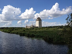
Almere Castle
Castle in Flevoland, Netherlands
Distance: Approx. 3354 meters
Latitude and longitude: 52.3482,5.2474
Almere Castle is a half-finished castle in the Dutch town of Almere in the province of Flevoland, Netherlands. Construction started in 2000 but was halted in 2002, after which the building has turned into a contemporary ruin. It is located on the Oude Waterlandseweg in Almere Haven and is visible from the A6 motorway.
Weather in this IP's area
overcast clouds
15 Celsius
15 Celsius
14 Celsius
16 Celsius
997 hPa
95 %
997 hPa
997 hPa
10000 meters
1.34 m/s
3.58 m/s
155 degree
100 %
07:52:30
19:00:25