Country:
 Canada
Region:
City:
Latitude and Longitude:
Time Zone:
Postal Code:
IP information under different IP Channel
ip-api
Country
Region
City
ASN
Time Zone
ISP
Blacklist
Proxy
Latitude
Longitude
Postal
Route
IPinfo
Country
Region
City
ASN
Time Zone
ISP
Blacklist
Proxy
Latitude
Longitude
Postal
Route
MaxMind
Country
Region
City
ASN
Time Zone
ISP
Blacklist
Proxy
Latitude
Longitude
Postal
Route
Luminati
Country
CARegion
on
City
milton
ASN
Time Zone
America/Toronto
ISP
ROGERS-COMMUNICATIONS
Latitude
Longitude
Postal
db-ip
Country
Region
City
ASN
Time Zone
ISP
Blacklist
Proxy
Latitude
Longitude
Postal
Route
ipdata
Country
Region
City
ASN
Time Zone
ISP
Blacklist
Proxy
Latitude
Longitude
Postal
Route
Popular places and events near this IP address

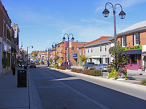
Milton, Ontario
Town in Ontario, Canada
Distance: Approx. 690 meters
Latitude and longitude: 43.50833333,-79.88333333
Milton (2021 census population 132,979) is a town in Southern Ontario, Canada, and part of the Halton Region in the Greater Toronto Area. Between 2001 and 2011, Milton was the fastest growing municipality in Canada, with a 71.4% increase in population from 2001 to 2006 and another 56.5% increase from 2006 to 2011. In 2016, Milton's census population was 110,128 with an estimated growth to 228,000 by 2031.
Regional Municipality of Halton
Regional municipality in Ontario, Canada
Distance: Approx. 667 meters
Latitude and longitude: 43.50833333,-79.88777778
The Regional Municipality of Halton, or Halton Region, is a regional municipality in Ontario, Canada, located in the Golden Horseshoe of Southern Ontario. It comprises the city of Burlington and the towns of Oakville, Milton, and Halton Hills. Policing in the Region is provided by the Halton Regional Police Service.

Milton GO Station
Railway station in Ontario, Canada
Distance: Approx. 1849 meters
Latitude and longitude: 43.52361111,-79.86722222
Milton GO Station is the western terminus of GO Transit's Milton line in the Greater Toronto Area, Ontario, Canada. It is located at 780 Main Street East in the Town of Milton, near Main Street and Ontario Street.

Ernest C. Drury School for the Deaf
Provincial school for the deaf school in Milton, Ontario, Canada
Distance: Approx. 1332 meters
Latitude and longitude: 43.5141,-79.8696
The Ernest C. Drury School for the Deaf is a provincial school in Milton, Ontario, Canada with residential and day programs serving elementary and secondary deaf and hard-of-hearing students. Along with three (SJW and Robarts School for the Deaf) other provincial schools for the deaf in Ontario, it is operated by the Ministry of Education under Education Act of Ontario section 13 (1). Teachers are both deaf and hearing.
Milton District High School
High school in Milton, Ontario, Canada
Distance: Approx. 1529 meters
Latitude and longitude: 43.506,-79.8709
Milton District High School (MDHS) is a public secondary school located in Milton, Ontario, Canada. MDHS is part of the Halton District School Board, and educates approximately 1700 students. Prior to Milton district high school's (second) opening in 1960, Students had attended the old Milton district high school on Martin street .
E. C. Drury High School
Secondary school in Milton, Ontario, Canada
Distance: Approx. 1244 meters
Latitude and longitude: 43.5145,-79.8707
The Ernest C. Drury High School was a school in Milton, Ontario, Canada, for students in grades 9-12. The school closed in June 2012 and became Craig Kielburger Secondary School at a new location in Milton. The same campus also houses the E. C. Drury School for the Deaf, a secondary school with residential and day programs for Deaf and Hard-of-Hearing students.
Fifth Wheel Truck Stops
Distance: Approx. 1734 meters
Latitude and longitude: 43.524376,-79.902359
The Fifth Wheel Truck Stops was a chain of truck stops, with locations in Ontario, Manitoba and New Brunswick. They also offered motel service, restaurants, and truck/RV cleaning. The Milton location appeared in key scenes of the 1978 film High-Ballin'.
Maplehurst Correctional Complex
Prison in Ontario, Canada
Distance: Approx. 1665 meters
Latitude and longitude: 43.52638889,-79.89805556
Maplehurst Correctional Complex (French: Complexe Correctionnel de Maplehurst) is a correctional facility located in Milton, Ontario for women and men 18 years of age and older. It is a combined maximum security detention centre for remanded prisoners, and medium/maximum correctional centre for offenders sentenced to less than two years. It used to have a separate wing for minors (12 to 17 years of age) but no longer houses them.
Vanier Centre for Women
Canadian prison and treatment facility for women
Distance: Approx. 1608 meters
Latitude and longitude: 43.524727,-79.899745
The Vanier Centre for Women (French: Centre Vanier pour les femmes) in Milton, Ontario is a medium correctional facility for female offenders serving sentences of less than two years or who have been arrested and are remanded in custody awaiting trial. The institution has capacity for 333 inmates. Services for French-speaking people are offered at this facility.
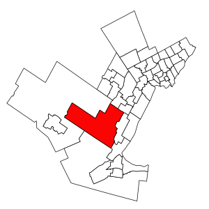
Milton (federal electoral district)
Federal electoral district in Ontario, Canada
Distance: Approx. 245 meters
Latitude and longitude: 43.512,-79.886
Milton is a federal electoral district in Ontario, Canada, that consists of the town of Milton and part of Burlington which has a population growing much faster than the Ontario average. It was created by the 2012 federal redistribution and previously part of Halton. Redistributed results showed that Conservative Lisa Raitt won the area easily in 2011, although her vote share dropped in the 2015 election and the Liberals took the riding in 2019.
Milton (provincial electoral district)
Provincial electoral district in Ontario, Canada
Distance: Approx. 245 meters
Latitude and longitude: 43.512,-79.886
Milton is a provincial electoral district in Ontario, Canada. It elects one member to the Legislative Assembly of Ontario. The riding was created in 2015.

Mill Pond (Milton, Ontario)
Lake in Ontario, Canada
Distance: Approx. 24 meters
Latitude and longitude: 43.51416667,-79.88638889
Mill Pond is a manmade freshwater reservoir in downtown Milton, Ontario, Canada. The pond is located on the main street of downtown Milton, a suburban town north of Lake Ontario in the Regional Municipality of Halton. Halton is the west wing of Greater Toronto Area bordering Niagara escapement to the west.
Weather in this IP's area
clear sky
6 Celsius
5 Celsius
4 Celsius
7 Celsius
1033 hPa
83 %
1033 hPa
1009 hPa
10000 meters
1.73 m/s
2.75 m/s
275 degree
07:37:41
18:31:10