Country:
 Canada
Region:
City:
Latitude and Longitude:
Time Zone:
Postal Code:
IP information under different IP Channel
ip-api
Country
Region
City
ASN
Time Zone
ISP
Blacklist
Proxy
Latitude
Longitude
Postal
Route
IPinfo
Country
Region
City
ASN
Time Zone
ISP
Blacklist
Proxy
Latitude
Longitude
Postal
Route
MaxMind
Country
Region
City
ASN
Time Zone
ISP
Blacklist
Proxy
Latitude
Longitude
Postal
Route
Luminati
Country
CARegion
on
City
markham
ASN
Time Zone
America/Toronto
ISP
ROGERS-COMMUNICATIONS
Latitude
Longitude
Postal
db-ip
Country
Region
City
ASN
Time Zone
ISP
Blacklist
Proxy
Latitude
Longitude
Postal
Route
ipdata
Country
Region
City
ASN
Time Zone
ISP
Blacklist
Proxy
Latitude
Longitude
Postal
Route
Popular places and events near this IP address
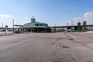
Unionville GO Station
Railway station in Markham, Ontario, Canada
Distance: Approx. 1684 meters
Latitude and longitude: 43.85166667,-79.31444444
Unionville GO Station is a train and bus station in the GO Transit network located in Markham, Ontario, Canada. It is a stop on the Stouffville line. The station is also served by Highway 407 East Express buses, which run westbound to Highway 407 station, northbound to Mount Joy GO Station, and eastbound to the Oshawa GO station.

Unionville High School (Ontario)
Public secondary school in Markham, Ontario, Canada
Distance: Approx. 2048 meters
Latitude and longitude: 43.86666667,-79.33333333
Unionville High School is a public high school of the York Region District School Board in Ontario, Canada. It is located west of the community of Unionville in the city of Markham. The school is located next to the Markham Civic Centre and the Markham Theatre.
Brown's Corners, Markham
Place in Ontario, Canada
Distance: Approx. 1910 meters
Latitude and longitude: 43.84972222,-79.35861111
Brown's Corners is an unincorporated community in Markham, Regional Municipality of York in the Greater Toronto Area of Ontario, Canada and located near the corner of Woodbine Avenue and Highway 7. The community, founded in 1842, was named for local settler Alexander Brown Sr. (1771–1851) who acquired 100 acres (40 ha) in 1838.

IBM Toronto Software Lab
Software development lab in Toronto, Canada
Distance: Approx. 292 meters
Latitude and longitude: 43.849013,-79.338399
The IBM Toronto Software Lab is the largest software development laboratory in Canada and IBM's third largest software lab. Established in 1967 with 55 employees, the Toronto Lab, now located in Markham has grown to employ 2,500 people. These employees develop some of IBM's middleware.

Markham Civic Centre
City hall in Ontario, Canada
Distance: Approx. 938 meters
Latitude and longitude: 43.8566,-79.3369
The Markham Civic Centre is the city hall of the city of Markham, Ontario. The brick and glass Civic Centre was designed by architect Arthur Erickson with Richard Stevens Architects Limited and was opened on May 25, 1990. The entrances, except for the great hall entrance, are named after communities in Markham (Unionville, Milliken, Thornhill).

Downtown Markham
Downtown in Ontario, Canada
Distance: Approx. 1211 meters
Latitude and longitude: 43.85,-79.32
Downtown Markham is the main downtown of Markham, Ontario, Canada. Currently under development, it is located near the historic Unionville district and serves as the new heart of Markham. Businesses in the district are expected to employ up to 16,000 individuals, and it may house as many as 10,000 residents.

Bill Crothers Secondary School
High school in Unionville, Ontario, Canada
Distance: Approx. 2045 meters
Latitude and longitude: 43.85666667,-79.31222222
Bill Crothers Secondary School is an athletic based high school in the community of Unionville in Markham, Ontario, Canada. It was the newest secondary school in the York Region District School Board for a number of years, since 2008. Named for the former Olympic athlete and Chair of the York Region District School Board, Bill Crothers, the school opened its doors to Grade 9 and 10 students in August 2008.

Beaver Creek (York Region)
River in Ontario, Canada
Distance: Approx. 121 meters
Latitude and longitude: 43.84722222,-79.33472222
Beaver Creek is a river in the municipalities of Markham and Richmond Hill in the Regional Municipality of York, part of the Greater Toronto Area of Ontario, Canada. It is part of the Great Lakes Basin and is a right tributary of the Rouge River.

CFMS-FM
Radio station in Markham, Ontario
Distance: Approx. 830 meters
Latitude and longitude: 43.855388,-79.338126
CFMS-FM (105.9 FM) is a Canadian radio station, transmitting at 105.9 MHz from Markham, Ontario. The station broadcasts a mixed format, with daytime programming featuring English-language adult contemporary music along with news, weather and traffic information targeted to York Region, and evening programming featuring a multilingual ethnic format in multiple languages, including Cantonese, Filipino, Hindi, Mandarin, Punjabi, Tamil and Urdu.

Flato Markham Theatre
Arts complex in Ontario, Canada
Distance: Approx. 1126 meters
Latitude and longitude: 43.85833333,-79.33666667
The Flato Markham Theatre is a public arts complex located at 171 Town Centre Boulevard in the city of Markham, Ontario, Canada. The theatre initially opened in 1985 for local and school based productions. The theatre is best known for its performances in performing arts and drama.
Warden Energy Centre
Distance: Approx. 191 meters
Latitude and longitude: 43.84816667,-79.33252778
Warden Energy Centre is a power station owned by Markham District Energy Incorporated situated at the northwest corner of Warden Avenue and Highway 407 in Markham, Ontario, Canada. The 5.2 MW CHP plant uses natural gas to power 2 Caterpillar G3612 natural gas driven reciprocating engine generator. The combined heating power plant, an 8.5MW CHP, first opened in 2000 with a 12 MW heating capacity and 40MW hot water thermal storage.
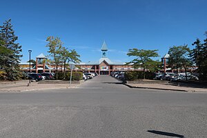
First Markham Place
Shopping mall in Ontario, Canada
Distance: Approx. 1138 meters
Latitude and longitude: 43.849159,-79.34903
First Markham Place is an Asian shopping mall located in Markham, Ontario, Canada. It is located on the south side of Highway 7, east of Woodbine Avenue and west of Warden Avenue. The mall opened in 1998, one year after the opening of Pacific Mall, the largest Asian shopping mall in the Western world, which is also located in Markham.
Weather in this IP's area
broken clouds
8 Celsius
7 Celsius
7 Celsius
10 Celsius
1014 hPa
79 %
1014 hPa
993 hPa
10000 meters
2.6 m/s
6.6 m/s
269 degree
64 %
06:49:21
19:40:42