Country:
 USA
USARegion:
City:
Latitude and Longitude:
Time Zone:
Postal Code:
IP information under different IP Channel
ip-api
Country
Region
City
ASN
Time Zone
ISP
Blacklist
Proxy
Latitude
Longitude
Postal
Route
IPinfo
Country
Region
City
ASN
Time Zone
ISP
Blacklist
Proxy
Latitude
Longitude
Postal
Route
MaxMind
Country
Region
City
ASN
Time Zone
ISP
Blacklist
Proxy
Latitude
Longitude
Postal
Route
Luminati
Country
USRegion
nc
City
fletcher
ASN
Time Zone
America/New_York
ISP
MORRISBB
Latitude
Longitude
Postal
db-ip
Country
Region
City
ASN
Time Zone
ISP
Blacklist
Proxy
Latitude
Longitude
Postal
Route
ipdata
Country
Region
City
ASN
Time Zone
ISP
Blacklist
Proxy
Latitude
Longitude
Postal
Route
Popular places and events near this IP address

Royal Pines, North Carolina
Census-designated place in North Carolina, United States
Distance: Approx. 3530 meters
Latitude and longitude: 35.47805556,-82.50361111
Royal Pines is a census-designated place (CDP) in Buncombe County, North Carolina, United States. The population was 4,272 at the 2010 census. It is part of the Asheville Metropolitan Statistical Area.
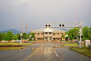
Fletcher, North Carolina
Town in North Carolina, United States
Distance: Approx. 1762 meters
Latitude and longitude: 35.43166667,-82.50388889
Fletcher is a town in Henderson County, North Carolina, United States. The population was 7,187 at the 2010 census, and was estimated to be 8,333 in 2018. Fletcher is adjacent to Asheville Regional Airport, which serves western North Carolina.

Asheville Regional Airport
Airport located in Fletcher, North Carolina, USA
Distance: Approx. 4149 meters
Latitude and longitude: 35.43611111,-82.54166667
Asheville Regional Airport (IATA: AVL, ICAO: KAVL, FAA LID: AVL) is a Class C airport near Interstate 26 and the town of Fletcher, North Carolina, 9 miles (14 km) south of downtown Asheville. It is owned by the Greater Asheville Regional Airport Authority. The Federal Aviation Administration (FAA) National Plan of Integrated Airport Systems for 2019–2023 categorized it as a small-hub primary commercial service facility.
Arden, North Carolina
Place in North Carolina, United States
Distance: Approx. 2741 meters
Latitude and longitude: 35.46611111,-82.51638889
Arden is an unincorporated community located in southern Buncombe County, North Carolina, United States. Arden is considered to be approximately the area between Skyland and Fletcher near the Henderson County line. Arden's ZIP code is 28704.
T. C. Roberson High School
Public school in North Carolina, United States
Distance: Approx. 5551 meters
Latitude and longitude: 35.486225,-82.5351218
T.C. Roberson High School is a high school in the Buncombe County Schools System in Asheville, North Carolina. It is located at 250 Overlook Road, Asheville, NC 28803. TC Roberson High School was founded when Valley Springs High School and Biltmore High School were combined to form one high school.
Skyland, North Carolina
Unincorporated community in North Carolina, US
Distance: Approx. 5286 meters
Latitude and longitude: 35.489,-82.524288
Skyland is an unincorporated community in Buncombe County, North Carolina, United States. It is on U.S. Route 25, where North Carolina Highway 146 starts, east of Interstate 26. It is north of Royal Pines, south of Biltmore Forest, and a suburb of Asheville.

Christ School (North Carolina)
School in Arden, North Carolina, United States
Distance: Approx. 2220 meters
Latitude and longitude: 35.4648376,-82.4876201
Christ School is a private college preparatory boarding and day school for boys in Arden, North Carolina, a suburb of Asheville, in the Blue Ridge Mountains. While affiliated with the Episcopal Church, it is open to students of all faiths and backgrounds.

Rugby Grange
Historic house in North Carolina, United States
Distance: Approx. 3558 meters
Latitude and longitude: 35.42083333,-82.52083333
The Rugby Grange, near Fletcher, Henderson County, North Carolina, was built in 1860 in Italianate architecture. The property includes agricultural outbuildings, agricultural fields and secondary structure, a total of 12 contributing buildings and one other contributing site. They include Rugby Lodge II, the "Big House", the Cottage, the Shanty, Uncle Martin's and Uncle Billy's cabins, the ice house, and several barns.
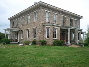
The Meadows (Fletcher, North Carolina)
Historic house in North Carolina, United States
Distance: Approx. 1181 meters
Latitude and longitude: 35.43638889,-82.49472222
The Meadows, also known as The Blake House, is a historic home located near Fletcher, Henderson County, North Carolina. It was built about 1860, and is a two-story, granite rubble stone dwelling in the Italianate style. It has a low hipped roof pierced with three interior chimneys and a two-story rear extension.
Naples, North Carolina
Unincorporated community in North Carolina, United States
Distance: Approx. 6039 meters
Latitude and longitude: 35.3925,-82.50055556
Naples is an unincorporated community in Henderson County, North Carolina, United States and is part of the Asheville Metropolitan Statistical Area. It is located near U.S. Route 25 Business (US 25 Bus.) and Interstate 26 (I-26) exit 44.
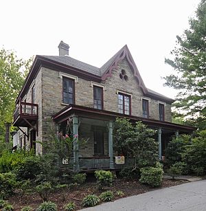
Blake House (Arden, North Carolina)
Historic house in North Carolina, United States
Distance: Approx. 3543 meters
Latitude and longitude: 35.47444444,-82.51694444
Blake House, also known as Newington, Royal Pines, and Joseph B. Pyatt House, is a historic home located at Arden, Buncombe County, North Carolina. It was built about 1850, and is a two-story, double pile stone house in the Gothic Revival style. The main block is five bays wide and has a hipped roof.

Lake Julian (North Carolina)
Reservoir in Buncombe County, North Carolina
Distance: Approx. 4804 meters
Latitude and longitude: 35.47527778,-82.5375
Lake Julian is a reservoir in Buncombe County, North Carolina, that was formerly used to cool a nearby power plant.
Weather in this IP's area
overcast clouds
25 Celsius
25 Celsius
23 Celsius
27 Celsius
1012 hPa
71 %
1012 hPa
939 hPa
10000 meters
1.54 m/s
100 %
07:16:05
19:31:13