Country:
 USA
USARegion:
City:
Latitude and Longitude:
Time Zone:
Postal Code:
IP information under different IP Channel
ip-api
Country
Region
City
ASN
Time Zone
ISP
Blacklist
Proxy
Latitude
Longitude
Postal
Route
IPinfo
Country
Region
City
ASN
Time Zone
ISP
Blacklist
Proxy
Latitude
Longitude
Postal
Route
MaxMind
Country
Region
City
ASN
Time Zone
ISP
Blacklist
Proxy
Latitude
Longitude
Postal
Route
Luminati
Country
USRegion
nc
City
highlands
ASN
Time Zone
America/New_York
ISP
HIGHLANDS-CABLE
Latitude
Longitude
Postal
db-ip
Country
Region
City
ASN
Time Zone
ISP
Blacklist
Proxy
Latitude
Longitude
Postal
Route
ipdata
Country
Region
City
ASN
Time Zone
ISP
Blacklist
Proxy
Latitude
Longitude
Postal
Route
Popular places and events near this IP address
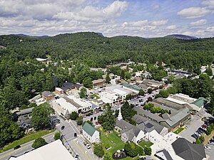
Highlands, North Carolina
Town in North Carolina, United States
Distance: Approx. 2376 meters
Latitude and longitude: 35.05361111,-83.1975
Highlands is an incorporated town in Macon County in the U.S. state of North Carolina. Located on a plateau in the southern Appalachian Mountains, within the Nantahala National Forest, it lies mostly in southeastern Macon County and slightly in southwestern Jackson County, in the Highlands and Cashiers Townships, respectively. The permanent population was 1,014 at the 2020 census.
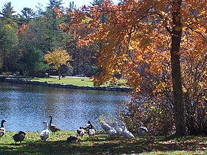
Harris Lake (Highlands, North Carolina)
Distance: Approx. 2905 meters
Latitude and longitude: 35.05,-83.19361111
Harris Lake is located just outside Downtown Highlands, North Carolina. It is a popular spot for fishing and picnicking. Harris Lake is home to many geese, swans and ducks.
Cliffside Lake Recreation Area
Distance: Approx. 2214 meters
Latitude and longitude: 35.0794,-83.2368
The Cliffside Lake Recreation Area is located in Nantahala National Forest in the Appalachian Mountains of North Carolina. It offers both fishing and swimming and is less than ten miles northwest of Highlands, North Carolina on State Road 28.

Church of the Incarnation (Highlands, North Carolina)
Historic church in North Carolina, United States
Distance: Approx. 2610 meters
Latitude and longitude: 35.05194444,-83.19583333
The Church of the Incarnation built in 1896 is a historic Carpenter Gothic Episcopal church building located at 111 North 5th Street in Highlands, Macon County, North Carolina. The Rev. John A. Deal, the first Episcopal missioner in Macon County, was responsible for founding the Church of the Incarnation as well Saint Agnes Episcopal Church in Franklin, the county seat.

First Presbyterian Church (Highlands, North Carolina)
Historic church in North Carolina, United States
Distance: Approx. 2572 meters
Latitude and longitude: 35.05166667,-83.19666667
The First Presbyterian Church is a historic church at 471 Main Street in Highlands, North Carolina. The single story wood-frame church was built in 1883–85, and occupies a prominent site in downtown Highlands, surrounded by a period picket fence. It is the oldest church in the city, and was built by Marion Wright, a local master builder.

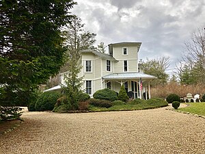
Baldwin-Coker Cottage
Historic house in North Carolina, United States
Distance: Approx. 3107 meters
Latitude and longitude: 35.05527778,-83.18694444
The Baldwin-Coker Cottage is a historic house at 266 Lower Lake Road in Highlands, North Carolina. The Rustic-style 1+1⁄2-story log house was designed and built in 1925 by James John Baldwin, an architect from Anderson, South Carolina. The cottage is important as a prototype for a number of later houses that were built by members of the construction crew.

Cabin Ben
Historic house in North Carolina, United States
Distance: Approx. 798 meters
Latitude and longitude: 35.06388889,-83.21
Cabin Ben is a historic log house at 115 Cullasaja Drive in Highlands, North Carolina. The house consists of two rectangular sections, joined at an offset. The smaller of the two sections houses a large living room, while the larger section houses the kitchen, dining, and bedroom areas.
Edwards Hotel (Highlands, North Carolina)
United States historic place
Distance: Approx. 2514 meters
Latitude and longitude: 35.05194444,-83.19722222
The Hotel Edwards was a historic hotel building at Main and 4th Streets in Highlands, North Carolina. The main block of the hotel, a three-story brick structure, was built in 1935. It was attached to a c.

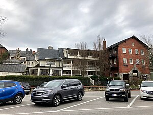
Highlands Inn
United States historic place
Distance: Approx. 2493 meters
Latitude and longitude: 35.05277778,-83.19666667
The Highlands Inn is a historic hotel at the corner of 4th and Main Streets in Highlands, North Carolina. The main block of the hotel is a three-story late Victorian structure built in 1880, with a two-story porch across the main facade. Over the course of the 20th century a number of alterations and additions have been made to this structure, to increase services and rooms.
Highlands North Historic District
Historic district in North Carolina, United States
Distance: Approx. 2344 meters
Latitude and longitude: 35.05833333,-83.19444444
The Highlands North Nistoric District encompasses the historic heart of Highlands, North Carolina, a summer resort town high in the state's western mountains. Its 60 acres (24 ha) include some of the first permanent year-round settlements in the town (established 1875), as well as a high concentration of its oldest surviving structures. It is laid out north of Main Street, the commercial heart of the town, roughly between North 4th Street (United States Route 64) and North 5th Street.
Playmore–Bowery Road Historic District
Historic district in North Carolina, United States
Distance: Approx. 4008 meters
Latitude and longitude: 35.05388889,-83.17694444
The Playmore–Bowery Road Historic District is a residential historic district composed of a collection of summer resort houses in the hills east of Highlands, North Carolina. The principal estate in the area, called Playmore, was established by the Ravenel family in 1879–80; it is situated on 140 acres (57 ha) south of Horse Cove Road. Bowery Road roughly parallels Horse Cove Road to the north, and is lined with a series of wood-frame summer that were built between about 1880 and 1930.
Satulah Mountain Historic District
Historic district in North Carolina, United States
Distance: Approx. 3273 meters
Latitude and longitude: 35.0425,-83.19777778
The Satulah Mountain Historic District is a residential historic district in Highlands, North Carolina. It is located in the southwestern part of the city, bounded on the north and west by Walhalla Road, on the east by properties on Satulah Road. The area is located on the slopes of Satulah Mountain, and was most significantly developed in the early decades of the 20th century, although the earliest development took place not long after Highlands was founded in 1875.
Weather in this IP's area
overcast clouds
23 Celsius
23 Celsius
21 Celsius
24 Celsius
1013 hPa
65 %
1013 hPa
888 hPa
10000 meters
0.78 m/s
1.21 m/s
132 degree
100 %
07:19:02
19:34:02