Country:
 USA
USARegion:
City:
Latitude and Longitude:
Time Zone:
Postal Code:
IP information under different IP Channel
ip-api
Country
Region
City
ASN
Time Zone
ISP
Blacklist
Proxy
Latitude
Longitude
Postal
Route
IPinfo
Country
Region
City
ASN
Time Zone
ISP
Blacklist
Proxy
Latitude
Longitude
Postal
Route
MaxMind
Country
Region
City
ASN
Time Zone
ISP
Blacklist
Proxy
Latitude
Longitude
Postal
Route
Luminati
Country
USRegion
nc
City
hendersonville
ASN
Time Zone
America/New_York
ISP
MORRISBB
Latitude
Longitude
Postal
db-ip
Country
Region
City
ASN
Time Zone
ISP
Blacklist
Proxy
Latitude
Longitude
Postal
Route
ipdata
Country
Region
City
ASN
Time Zone
ISP
Blacklist
Proxy
Latitude
Longitude
Postal
Route
Popular places and events near this IP address
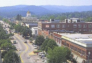
Hendersonville, North Carolina
City in North Carolina, United States
Distance: Approx. 4776 meters
Latitude and longitude: 35.32472222,-82.45722222
Hendersonville is a city in and the county seat of Henderson County, North Carolina, United States, located 22 miles (35 km) south of Asheville. Like the county, the city is named for 19th-century North Carolina Supreme Court Chief Justice Leonard Henderson. The population was 13,137 at the 2010 census and was estimated in 2019 to be 14,157.

Piedmont Airlines Flight 22
1967 mid-air collision
Distance: Approx. 2690 meters
Latitude and longitude: 35.33722222,-82.43777778
Piedmont Airlines Flight 22 was a Piedmont Airlines Boeing 727-22 that collided with a twin-engine Cessna 310 on July 19, 1967, over Hendersonville, North Carolina, United States. Both aircraft were destroyed and all passengers and crew were killed, including John T. McNaughton, an advisor to U.S. Secretary of Defense Robert McNamara. The aircraft were both operating under instrument flight rules and were in radio contact with the Asheville control tower, though on different frequencies.
WHKP
Radio station in Hendersonville, North Carolina
Distance: Approx. 3497 meters
Latitude and longitude: 35.33888889,-82.45555556
WHKP is a radio station broadcasting at 1450 on the AM dial in Hendersonville, North Carolina. The call letters stand for Where the Heavens Kiss the Peaks. The station broadcasts to most of the area in Henderson County and parts of southern Buncombe and parts of northern Polk Counties.
Fruitland, Henderson County, North Carolina
Census-designated place in North Carolina, United States
Distance: Approx. 3926 meters
Latitude and longitude: 35.39277778,-82.41194444
Fruitland is an unincorporated community and census-designated place (CDP) in Henderson County, North Carolina, United States. Its population was 2,031 as of the 2010 census.
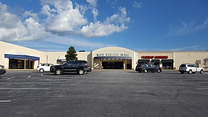
Blue Ridge Mall (North Carolina)
Shopping mall in Hendersonville, North Carolina
Distance: Approx. 3295 meters
Latitude and longitude: 35.33424,-82.44532
Blue Ridge Mall is a shopping mall located in Hendersonville, North Carolina that opened in 1983. It is anchored by Belk and Dunham's Sports, with junior anchors TJ Maxx and Jo-Ann Fabrics, and is owned by Hull Property Group.

Clough H. Rice House
Historic house in North Carolina, United States
Distance: Approx. 5089 meters
Latitude and longitude: 35.33861111,-82.47638889
Clough H. Rice House is a historic home located at Hendersonville, Henderson County, North Carolina. It was built about 1875, and is a two-story, single-pile, frame I-house, with Italianate style design elements. It has a two-story, gable-roofed rear ell.

Cold Spring Park Historic District
Historic district in North Carolina, United States
Distance: Approx. 4974 meters
Latitude and longitude: 35.32472222,-82.46083333
Cold Spring Park Historic District, also known as Wheeler Park, is a national historic district located at Hendersonville, Henderson County, North Carolina. The district encompasses 37 contributing buildings and 1 contributing structure in a predominantly residential section of Hendersonville developed between 1910 and 1953. It includes notable examples of Colonial Revival and Bungalow / American Craftsman residential architecture.

Druid Hills Historic District (Hendersonville, North Carolina)
Historic district in North Carolina, United States
Distance: Approx. 5195 meters
Latitude and longitude: 35.33027778,-82.47111111
Druid Hills Historic District is a national historic district located at Hendersonville, Henderson County, North Carolina. The district encompasses 76 contributing buildings in a predominantly residential section of Hendersonville developed between 1910 and 1945. It includes notable examples of Tudor Revival and Bungalow / American Craftsman residential architecture.
Hyman Heights–Mount Royal Historic District
Historic district in North Carolina, United States
Distance: Approx. 4997 meters
Latitude and longitude: 35.32722222,-82.46472222
Hyman Heights–Mount Royal Historic District is a national historic district located at Hendersonville, Henderson County, North Carolina. The district encompasses 123 contributing buildings in a predominantly residential section of Hendersonville developed between 1905 and 1954. It includes notable examples of Colonial Revival and Bungalow / American Craftsman residential architecture.
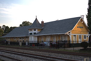
Seventh Avenue Depot District
Historic district in North Carolina, United States
Distance: Approx. 5070 meters
Latitude and longitude: 35.32166667,-82.4575
Seventh Avenue Depot District is a national historic district located at Hendersonville, Henderson County, North Carolina. The district encompasses 27 contributing buildings and 1 contributing structure in Hendersonville. The district consists of the frame early 20th century depot, a block of original brick street pavement beside it, twenty-seven stores and warehouses, a hotel, and two houses.
Brittain Creek
Stream in Henderson County, North Carolina, U.S.
Distance: Approx. 4366 meters
Latitude and longitude: 35.33861111,-82.46722222
Brittain Creek is a stream in Henderson County, North Carolina, in the United States. It is a tributary of Mud Creek. The stream was named for James C. Brittain, a pioneer who settled along the creek.
North Henderson High School
American public school in North Carolina
Distance: Approx. 386 meters
Latitude and longitude: 35.36111111,-82.42277778
North Henderson High School is a public high school located in Hendersonville, North Carolina. It is one of four public high schools located in Henderson County. North Henderson was founded in 1993, as the majority of students were moved from the now closed Edneyville High School.
Weather in this IP's area
scattered clouds
16 Celsius
16 Celsius
15 Celsius
18 Celsius
1021 hPa
89 %
1021 hPa
947 hPa
10000 meters
40 %
07:10:42
19:41:12