Country:
 USA
USARegion:
City:
Latitude and Longitude:
Time Zone:
Postal Code:
IP information under different IP Channel
ip-api
Country
Region
City
ASN
Time Zone
ISP
Blacklist
Proxy
Latitude
Longitude
Postal
Route
IPinfo
Country
Region
City
ASN
Time Zone
ISP
Blacklist
Proxy
Latitude
Longitude
Postal
Route
MaxMind
Country
Region
City
ASN
Time Zone
ISP
Blacklist
Proxy
Latitude
Longitude
Postal
Route
Luminati
Country
USRegion
nc
City
hendersonville
ASN
Time Zone
America/New_York
ISP
MORRISBB
Latitude
Longitude
Postal
db-ip
Country
Region
City
ASN
Time Zone
ISP
Blacklist
Proxy
Latitude
Longitude
Postal
Route
ipdata
Country
Region
City
ASN
Time Zone
ISP
Blacklist
Proxy
Latitude
Longitude
Postal
Route
Popular places and events near this IP address

Henderson County, North Carolina
County in North Carolina, United States
Distance: Approx. 3136 meters
Latitude and longitude: 35.34,-82.48
Henderson County is a county located in the U.S. state of North Carolina. As of the 2020 census, the population was 116,281. Its county seat is Hendersonville.

Balfour, North Carolina
Census-designated place in North Carolina, United States
Distance: Approx. 2871 meters
Latitude and longitude: 35.34944444,-82.4825
Balfour is an unincorporated community and census-designated place (CDP) in Henderson County, North Carolina, United States. The population was 1,187 at the 2010 census. It is part of the Asheville Metropolitan Statistical Area.

Laurel Park, North Carolina
Town in North Carolina, United States
Distance: Approx. 3905 meters
Latitude and longitude: 35.31166667,-82.50388889
Laurel Park is a town in Henderson County, North Carolina, United States. The population was 2,250 at the 2020 census. It is part of the Asheville Metropolitan Statistical Area.
Mountain Home, North Carolina
Census-designated place in North Carolina, United States
Distance: Approx. 2978 meters
Latitude and longitude: 35.37083333,-82.50222222
Mountain Home is an unincorporated community and census-designated place (CDP) in Henderson County, North Carolina, United States. The population was 3,622 at the 2010 census, up from 2,169 in 2000. It is part of the Asheville Metropolitan Statistical Area.
Horse Shoe, North Carolina
Census-designated place in North Carolina, United States
Distance: Approx. 3938 meters
Latitude and longitude: 35.34222222,-82.55694444
Horse Shoe is an unincorporated community and census-designated place (CDP) in Henderson County, North Carolina, United States. Its ZIP code is 28742. As of the 2010 census, its population was 2,351.
Moss–Johnson Farm
Historic farm in North Carolina, United States
Distance: Approx. 1583 meters
Latitude and longitude: 35.35944444,-82.50888889
Moss–Johnson Farm, also known as the Johnson Farm, is a historic farm complex located near Hendersonville, Henderson County, North Carolina, United States. The farmhouse was built between 1874 and 1880, and is a rectangular brick dwelling measuring 50 feet by 28 feet. Also on the property are the contributing clapboard summer house (1920), a granary and smokehouse (1880), a well, a barn (1923), a small dwelling (1933), and a hen house and pig barn.

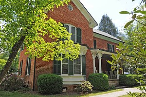
Erle Stillwell House
Historic house in North Carolina, United States
Distance: Approx. 4444 meters
Latitude and longitude: 35.31805556,-82.47861111
Erle Stillwell House is a historic home located at Hendersonville, Henderson County, North Carolina. It was built in 1926, and is a two-story, L-plan Tudor Revival style brick dwelling. It has a multi-gable and hip roof with flared gable ends and two brick chimneys with chimney pots.
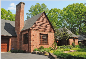
Erle Stillwell House II
Historic house in North Carolina, United States
Distance: Approx. 4524 meters
Latitude and longitude: 35.3175,-82.47805556
Erle Stillwell House II is a historic home located at Hendersonville, Henderson County, North Carolina. It was built in 1935, and is a one-story, eclectic French Eclectic brick dwelling with some Tudor Revival style design elements. It has a multi-gable and hip roof and a massive brick chimney at the juncture between the main house and the garage wing.

Clough H. Rice House
Historic house in North Carolina, United States
Distance: Approx. 3490 meters
Latitude and longitude: 35.33861111,-82.47638889
Clough H. Rice House is a historic home located at Hendersonville, Henderson County, North Carolina. It was built about 1875, and is a two-story, single-pile, frame I-house, with Italianate style design elements. It has a two-story, gable-roofed rear ell.

Singletary-Reese-Robinson House
Historic house in North Carolina, United States
Distance: Approx. 4142 meters
Latitude and longitude: 35.31055556,-82.49916667
Singletary-Reese-Robinson House, also known as Woodlawn, is a historic home located at Laurel Park, Henderson County, North Carolina. It was built in 1912, and is a two-story, "L"-form, Rustic Revival style log dwelling. It has a two-story rear wing addition and features a hip-roof wraparound porch.

Druid Hills Historic District (Hendersonville, North Carolina)
Historic district in North Carolina, United States
Distance: Approx. 4244 meters
Latitude and longitude: 35.33027778,-82.47111111
Druid Hills Historic District is a national historic district located at Hendersonville, Henderson County, North Carolina. The district encompasses 76 contributing buildings in a predominantly residential section of Hendersonville developed between 1910 and 1945. It includes notable examples of Tudor Revival and Bungalow / American Craftsman residential architecture.
Brittain Creek
Stream in Henderson County, North Carolina, U.S.
Distance: Approx. 4305 meters
Latitude and longitude: 35.33861111,-82.46722222
Brittain Creek is a stream in Henderson County, North Carolina, in the United States. It is a tributary of Mud Creek. The stream was named for James C. Brittain, a pioneer who settled along the creek.
Weather in this IP's area
overcast clouds
18 Celsius
18 Celsius
17 Celsius
19 Celsius
1015 hPa
97 %
1015 hPa
929 hPa
10000 meters
2.06 m/s
10 degree
100 %
07:16:10
19:31:16