Country:
 USA
USARegion:
City:
Latitude and Longitude:
Time Zone:
Postal Code:
IP information under different IP Channel
ip-api
Country
Region
City
ASN
Time Zone
ISP
Blacklist
Proxy
Latitude
Longitude
Postal
Route
IPinfo
Country
Region
City
ASN
Time Zone
ISP
Blacklist
Proxy
Latitude
Longitude
Postal
Route
MaxMind
Country
Region
City
ASN
Time Zone
ISP
Blacklist
Proxy
Latitude
Longitude
Postal
Route
Luminati
Country
USRegion
nh
City
hudson
ASN
Time Zone
America/New_York
ISP
TVC-AS1
Latitude
Longitude
Postal
db-ip
Country
Region
City
ASN
Time Zone
ISP
Blacklist
Proxy
Latitude
Longitude
Postal
Route
ipdata
Country
Region
City
ASN
Time Zone
ISP
Blacklist
Proxy
Latitude
Longitude
Postal
Route
Popular places and events near this IP address

The Mall of New Hampshire
Shopping mall in Manchester, New Hampshire, United States
Distance: Approx. 1480 meters
Latitude and longitude: 42.95611111,-71.43277778
The Mall of New Hampshire is a shopping mall located in the Lower South Willow neighborhood of Manchester, New Hampshire. Its major anchoring stores are Macy's, Old Navy, JCPenney, Dick's Sporting Goods, Best Buy, and Dave & Buster's. The mall has 125 stores as well as a large food court and is 798,881 square feet (74,218.5 m2), making it the third largest mall in New Hampshire after the Mall at Rockingham Park in Salem, and the Pheasant Lane Mall in Nashua, which opened in 1991 and 1986, respectively.
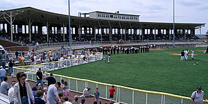
Gill Stadium
Sporting stadium located in Manchester, New Hampshire
Distance: Approx. 2253 meters
Latitude and longitude: 42.98194444,-71.45444444
Gill Stadium is a sporting stadium located in Manchester, New Hampshire. It is one of the oldest concrete-and-steel ballparks in the United States. The venue, which mainly hosts amateur baseball and football contests, has a capacity of 3,012.
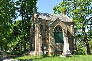
Valley Cemetery
Cemetery in New Hampshire, US
Distance: Approx. 2528 meters
Latitude and longitude: 42.98333333,-71.46
The Valley Cemetery (or the Valley Street Cemetery) is a public cemetery located in Manchester, New Hampshire, United States. It is bounded on the east by Pine Street, on the north by Auburn Street, on the west by Willow Street, and on the south by Valley Street, from which it derives its name. It was listed on the U.S. National Register of Historic Places in 2004, and the New Hampshire State Register of Historic Places in 2003.
Manchester Memorial High School
Public high school in Manchester, New Hampshire, United States
Distance: Approx. 1309 meters
Latitude and longitude: 42.9675,-71.43472222
Manchester Memorial High School is a four-year comprehensive school in Manchester, New Hampshire, with an enrollment of approximately 1,600. It is a part of the Manchester School District. The school's Latin motto is "scientia est potentia." Manchester Memorial accepts students from Manchester.

Manchester School of Technology
Career and technical school in Manchester, New Hampshire, USA
Distance: Approx. 1396 meters
Latitude and longitude: 42.96333333,-71.43194444
The Manchester School of Technology (MST) is a high school located at 100 Gerald Connors Circle, in Manchester, New Hampshire, United States, part of the Manchester School District. In addition to the typical high school courses, Manchester School of Technology offers courses called "Careers in Technology and Engineering" (CTE), which are programs of study that focus on applied applications, rather than the theoretical or abstract. These CTE classes are typically taken in the 10th and 11th grade, though can be taken in the 12th grade as well.

Piscataquog River
River in New Hampshire, United States
Distance: Approx. 2403 meters
Latitude and longitude: 42.97638889,-71.47111111
The Piscataquog River is a 34.7-mile-long (55.8 km) river located in southern New Hampshire in the United States. It is a tributary of the Merrimack River, which flows to the Gulf of Maine. The Piscataquog River begins at the outlet of Deering Reservoir, a lake in Deering, New Hampshire.

John F. Kennedy Memorial Coliseum
Indoor arena in Manchester, New Hampshire
Distance: Approx. 2409 meters
Latitude and longitude: 42.98333333,-71.45472222
John F. Kennedy Memorial Coliseum is an indoor arena in Manchester, New Hampshire, United States. It hosted the Northeastern Hockey League's Cape Cod Freedoms in 1979. The arena holds 1,600 people and opened in 1963.

Mount Washington College
For-profit college in Manchester, New Hampshire (1900–2016)
Distance: Approx. 2011 meters
Latitude and longitude: 42.97222222,-71.46944444
Mount Washington College was a for-profit college in Manchester, New Hampshire, United States. It opened in 1900 and was known as Hesser College until 2013. It was owned by Kaplan, Inc., and offered associate and bachelor's degrees focused in business and information technology, and claimed a flexible class scheduling system tailored to a diverse group of students.
Mount Zion Christian Schools (Manchester, New Hampshire)
Private christian school in Manchester, NH, USA
Distance: Approx. 818 meters
Latitude and longitude: 42.96083333,-71.45888889
Mount Zion Christian Schools is a private, coeducational Christian school located at 132 Titus Avenue in Manchester, New Hampshire, United States. The school offers traditional Christian education for grades pre-K-12.

Hoyt Shoe Factory
United States historic place
Distance: Approx. 1695 meters
Latitude and longitude: 42.97722222,-71.45138889
The Hoyt Shoe Factory is a historic factory complex at 470 Silver Street and 170 Lincoln Street in Manchester, New Hampshire. It consists of two once-identical four-story brick factory buildings which face each other across Silver Street. Built in the 1890s, they housed the city's largest shoe manufacturer, an industry that gained in significance as its textile industry declined.

Kimball Brothers Shoe Factory
United States historic place
Distance: Approx. 2342 meters
Latitude and longitude: 42.98194444,-71.43944444
The Kimball Brothers Shoe Factory is a historic factory building at 335 Cypress Street in Manchester, New Hampshire. The four-story brick building was built in stages between 1885 and 1900, and was a prototypical structure from which the design of other period shoe factories in Manchester were built. Construction was overseen by Head & Dowst, a builder responsible for a number of area public buildings, including schools and prisons.
The Founders Academy
Public charter school in Manchester, New Hampshire, United States
Distance: Approx. 1944 meters
Latitude and longitude: 42.946995,-71.437016
The Founders Academy is a charter school in Manchester, New Hampshire, United States. The academy's charter states that the focus is to provide a classical education with a business and law and ethics focus to students in grades five through twelve who reside in the state of New Hampshire.
Weather in this IP's area
clear sky
16 Celsius
15 Celsius
14 Celsius
17 Celsius
1030 hPa
46 %
1030 hPa
1021 hPa
10000 meters
3.6 m/s
350 degree
07:03:13
17:58:09