Country:
 USA
USARegion:
City:
Latitude and Longitude:
Time Zone:
Postal Code:
IP information under different IP Channel
ip-api
Country
Region
City
ASN
Time Zone
ISP
Blacklist
Proxy
Latitude
Longitude
Postal
Route
IPinfo
Country
Region
City
ASN
Time Zone
ISP
Blacklist
Proxy
Latitude
Longitude
Postal
Route
MaxMind
Country
Region
City
ASN
Time Zone
ISP
Blacklist
Proxy
Latitude
Longitude
Postal
Route
Luminati
Country
USRegion
ny
City
thiells
ASN
Time Zone
America/New_York
ISP
TVC-AS1
Latitude
Longitude
Postal
db-ip
Country
Region
City
ASN
Time Zone
ISP
Blacklist
Proxy
Latitude
Longitude
Postal
Route
ipdata
Country
Region
City
ASN
Time Zone
ISP
Blacklist
Proxy
Latitude
Longitude
Postal
Route
Popular places and events near this IP address

Tallman Mountain State Park
State park in New York, United States
Distance: Approx. 782 meters
Latitude and longitude: 41.028,-73.912
Tallman Mountain State Park is a 687-acre (2.78 km2) state park in Rockland County, New York, located adjacent to the Hudson River in the Town of Orangetown just south of Piermont. It is part of the Palisades Interstate Park System.
Rockland Country Club
Distance: Approx. 246 meters
Latitude and longitude: 41.02472222,-73.91777778
Rockland Country Club is located in Sparkill, New York, and features an 18-hole golf course.

Sparkill, New York
Census-designated place in New York, United States
Distance: Approx. 816 meters
Latitude and longitude: 41.03,-73.92805556
Sparkill, formerly known as Tappan Sloat, is a suburban hamlet and census-designated place in the Town of Orangetown, Rockland County, New York, United States located north of Palisades; east of Tappan; south of Piermont and west of the Hudson River. As of the 2010 census, the CDP had a population of 1,565. The hamlet is home to St.

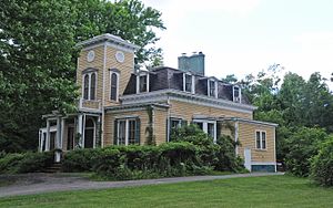
Dederer Stone House-Stonehurst
Historic house in New York, United States
Distance: Approx. 691 meters
Latitude and longitude: 41.03138889,-73.92222222
Dederer Stone House-Stonehurst is a historic home located at Orangetown in Rockland County, New York. It was built in 1865 and is a 2+1⁄2-story, T-shaped dwelling constructed using regular size units of local granite with dressed sandstone trim. It features a jerkinhead roof.
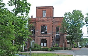
Haddock's Hall
Historic commercial building in New York, United States
Distance: Approx. 1120 meters
Latitude and longitude: 41.03527778,-73.91888889
Haddock's Hall is a historic commercial building located at Piermont in Rockland County, New York. It was built about 1875 and is a two-story, three bay wide, brick commercial / civic building. It features a three-story tower.

Rockland Road Bridge
United States historic place
Distance: Approx. 1084 meters
Latitude and longitude: 41.035,-73.91944444
Rockland Road Bridge is a historic stone and brick arch bridge located at Piermont in Rockland County, New York. It was built in 1874 and spans Sparkill Creek, a tributary of the Hudson River. The bridge is located southwest of the Sparkill Creek Drawbridge.
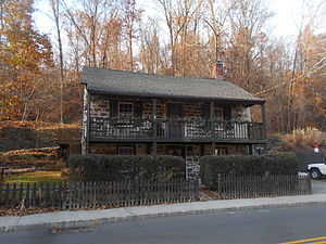
Hopson-Swan Estate
Historic house in New York, United States
Distance: Approx. 398 meters
Latitude and longitude: 41.02694444,-73.91638889
Hopson-Swan Estate is a national historic district and estate located at Sparkill in Rockland County, New York. It encompasses three contributing buildings and one contributing structure. The district is located within the boundaries of Tallman Mountain State Park and was acquired by the Palisades Interstate Park Commission in 1947.

Christ Church (Sparkill, New York)
Historic church in New York, United States
Distance: Approx. 700 meters
Latitude and longitude: 41.02986111,-73.92633333
Christ Church, also known as Christ Episcopal Church, is a historic Episcopal church located at Sparkill in Rockland County, New York. It was designed by architect Charles Babcock (1829–1913) and built in 1864–1865. It is a Gothic Revival style bluestone rubble church.
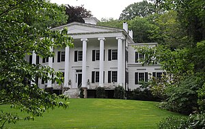
William Ferdon House
Historic house in New York, United States
Distance: Approx. 1089 meters
Latitude and longitude: 41.035,-73.91888889
William Ferdon House, also known as Ferdon Hall, is a historic home located at Piermont in Rockland County, New York. It was built about 1835, and is a two-story, Greek Revival style frame dwelling. It features a monumental front portico supported by six Ionic order columns.

Rockland Road Bridge Historic District
Historic district in New York, United States
Distance: Approx. 1084 meters
Latitude and longitude: 41.035,-73.91944444
Rockland Road Bridge Historic District is a national historic district located at Piermont in Rockland County, New York. The district encompasses 12 contributing buildings and 8 contributing structures in the village of Piermont. It developed between about 1785 and 1940, and includes representative examples of Federal, Greek Revival, Italianate, and Second Empire style architecture.
House at 352 Piermont Avenue
Historic house in New York, United States
Distance: Approx. 1298 meters
Latitude and longitude: 41.03694444,-73.91972222
House at 352 Piermont Avenue is a historic home located at Piermont, Rockland County, New York. It was built about 1780, and is a 2+1⁄2-story, side-gabled, sandstone Colonial period residence. A two-story frame addition was built about 1970.

First Reformed Church (Piermont, New York)
Historic church in New York, United States
Distance: Approx. 1272 meters
Latitude and longitude: 41.03638889,-73.91694444
First Reformed Church, also known as Piermont Reformed Church and First Protestant Dutch Church of Piermont, is a historic Reformed Church in America church located at Piermont, Rockland County, New York. It was built in 1946, and is a one-story, three-bay by four-bay, Wren-Gibbs Colonial Revival style church. It features a central square tower topped by a hexagonal steeple.
Weather in this IP's area
overcast clouds
23 Celsius
22 Celsius
21 Celsius
24 Celsius
1025 hPa
49 %
1025 hPa
1019 hPa
10000 meters
0.89 m/s
3.13 m/s
155 degree
100 %
06:37:42
19:03:13