Country:
 USA
USARegion:
City:
Latitude and Longitude:
Time Zone:
Postal Code:
IP information under different IP Channel
ip-api
Country
Region
City
ASN
Time Zone
ISP
Blacklist
Proxy
Latitude
Longitude
Postal
Route
IPinfo
Country
Region
City
ASN
Time Zone
ISP
Blacklist
Proxy
Latitude
Longitude
Postal
Route
MaxMind
Country
Region
City
ASN
Time Zone
ISP
Blacklist
Proxy
Latitude
Longitude
Postal
Route
Luminati
Country
USRegion
ny
City
saratogasprings
ASN
Time Zone
America/New_York
ISP
TVC-AS1
Latitude
Longitude
Postal
db-ip
Country
Region
City
ASN
Time Zone
ISP
Blacklist
Proxy
Latitude
Longitude
Postal
Route
ipdata
Country
Region
City
ASN
Time Zone
ISP
Blacklist
Proxy
Latitude
Longitude
Postal
Route
Popular places and events near this IP address

Gloversville, New York
City in New York, United States
Distance: Approx. 2048 meters
Latitude and longitude: 43.05,-74.35
Gloversville is a city in the Mohawk Valley region of Upstate New York, United States. The most populous city in Fulton County, it was once the hub of the United States' glovemaking industry, with over 200 manufacturers there and the adjacent city of Johnstown. In 2020, Gloversville had a population of 15,131.
Johnstown (town), New York
Town in New York, United States
Distance: Approx. 4726 meters
Latitude and longitude: 43.04583333,-74.38638889
Johnstown is a town located in Fulton County, New York, United States. As of the 2010 census, the town had a population of 7,098. The name of the town is from landowner William Johnson.
WFNY
Radio station in Gloversville, New York
Distance: Approx. 3777 meters
Latitude and longitude: 43.0325,-74.35055556
WFNY (1440 AM) is a commercial radio station licensed to Gloversville, New York, United States. Programming primarily consists of what is known as a variety format, focusing on pop music from the 1950s to the 1980s, along with local weather forecast, as the station has no local news department or sales department. WFNY serves the area of Upstate New York including the Mohawk Valley, Southern Adirondacks, and portions of the Capital Region.

First United Methodist Church (Gloversville, New York)
Historic church in New York, United States
Distance: Approx. 1710 meters
Latitude and longitude: 43.05194444,-74.34666667
First United Methodist Church is a historic United Methodist church at 7 Elm Street at Bleecker Square in Gloversville, Fulton County, New York. It was designed by Horatio Nelson White in the Romanesque Revival style and was built from 1869 to 1870. The main block / sanctuary is a two-story red brick structure set on a cut stone foundation.
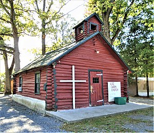
Log Cabin Church
Historic church in New York, United States
Distance: Approx. 4019 meters
Latitude and longitude: 43.042852,-74.294162
Log Cabin Church is a historic non-denominational church at 413 Progress Road in the hamlet of Progress in the town of Mayfield, Fulton County, New York. It was built in 1937 and is a 26 feet deep by 18 feet wide log structure constructed of white poplar logs laid horizontally. Also on the property is a privy and a parish activities hall.

Gustav Levor House
Historic house in New York, United States
Distance: Approx. 1388 meters
Latitude and longitude: 43.05305556,-74.34166667
The Gustav Levor House is a historic home located in Gloversville, Fulton County, New York. It was built in 1892 and is an irregularly massed, 2+1⁄2-story, frame, Queen Anne–style residence. It features complex massing, a polygonal wall bay, intersecting roofs and gables, and an engaged round corner tower with a conical roof.

Gloversville Armory
United States historic place
Distance: Approx. 1668 meters
Latitude and longitude: 43.05,-74.34055556
Gloversville Armory is a historic National Guard armory building located at 87 Washington Street in Gloversville, Fulton County, New York. It is a brick and red sandstone castle-like structure built from 1903 to 1904, designed to be reminiscent of medieval military structures in Europe. It was designed by State Architect George L. Heins in the Late Victorian style.

Gloversville Free Library
United States historic place
Distance: Approx. 1726 meters
Latitude and longitude: 43.05027778,-74.34333333
The Gloversville Public Library, located at 58 East Fulton Street in Gloversville, Fulton County, New York, was constructed in 1904 with funds provided by the philanthropist Andrew Carnegie. It is one of 3,000 such Carnegie libraries constructed between 1885 and 1919, and one of 107 in New York State. Carnegie contributed $50,000 toward the cost to build.

Oliver Rice House
Historic house in New York, United States
Distance: Approx. 6064 meters
Latitude and longitude: 43.1,-74.27777778
The Oliver Rice House, also called the Rice Homestead, is a historic home located at Mayfield in Fulton County, New York. Rice served in the American Revolutionary War under George Washington. The main section of the house was built about 1810 and is a large, 2-story, five-bay, center-chimney frame dwelling enlarged and expanded in three phases through 1936.

Downtown Gloversville Historic District
Historic district in New York, United States
Distance: Approx. 1748 meters
Latitude and longitude: 43.05083333,-74.34527778
The Downtown Gloversville Historic District is a national historic district located in Gloversville, Fulton County, New York. It is roughly bounded by Spring, Prospect, West and East Fulton, North and South Main, and Elm Streets. The district contains 78 contributing buildings centered on the city's "four corners" formed at the intersection of Main and Fulton Streets, but also included properties on Church, Fremont, Spring and Prospect Streets.

Kingsboro Historic District
Historic district in New York, United States
Distance: Approx. 375 meters
Latitude and longitude: 43.06694444,-74.33666667
The Kingsboro Historic District is a small national historic district located in Gloversville, Fulton County, New York. The district contains 18 contributing buildings and one contributing site. The district encompasses all the properties that face Veterans Park – formerly Kingsboro Avenue Park – plus five additional properties.
Kingsboro, New York
Hamlet in New York, United States
Distance: Approx. 669 meters
Latitude and longitude: 43.06722222,-74.34111111
Kingsboro (also Kingsborough) is a neighborhood in the northern part of the city of Gloversville, and an adjacent unincorporated community in the town of Johnstown in Fulton County, New York, United States.
Weather in this IP's area
clear sky
14 Celsius
13 Celsius
13 Celsius
16 Celsius
1031 hPa
66 %
1031 hPa
999 hPa
10000 meters
0.99 m/s
2.71 m/s
270 degree
07:14:53
18:09:33