Country:
 Canada
Region:
City:
Latitude and Longitude:
Time Zone:
Postal Code:
IP information under different IP Channel
ip-api
Country
Region
City
ASN
Time Zone
ISP
Blacklist
Proxy
Latitude
Longitude
Postal
Route
IPinfo
Country
Region
City
ASN
Time Zone
ISP
Blacklist
Proxy
Latitude
Longitude
Postal
Route
MaxMind
Country
Region
City
ASN
Time Zone
ISP
Blacklist
Proxy
Latitude
Longitude
Postal
Route
Luminati
Country
CARegion
on
City
portelgin
ASN
Time Zone
America/Toronto
ISP
BMTS
Latitude
Longitude
Postal
db-ip
Country
Region
City
ASN
Time Zone
ISP
Blacklist
Proxy
Latitude
Longitude
Postal
Route
ipdata
Country
Region
City
ASN
Time Zone
ISP
Blacklist
Proxy
Latitude
Longitude
Postal
Route
Popular places and events near this IP address
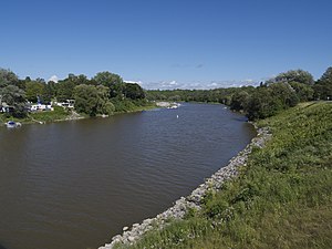
Saugeen River
River in Ontario, Canada
Distance: Approx. 7814 meters
Latitude and longitude: 44.50083333,-81.37361111
The Saugeen River is located in southern Ontario, Canada. The river begins in the Osprey Wetland Conservation Lands and flows generally north-west about 160 kilometres (99 mi) before exiting into Lake Huron. The river is navigable for some distance, and was once an important barge route.

Southampton, Ontario
Community in Ontario, Canada
Distance: Approx. 7257 meters
Latitude and longitude: 44.49555556,-81.37138889
Southampton is a community on the shores of Lake Huron in Bruce County, Ontario, Canada. It is close to Port Elgin and is located at the mouth of the Saugeen River in the Saugeen Ojibway Nation Territory. The size of the town is 6.44 square kilometres.
Saugeen Shores
Town in Ontario, Canada
Distance: Approx. 1555 meters
Latitude and longitude: 44.43333333,-81.36666667
Saugeen Shores is a town in Bruce County, Ontario, Canada, formed in 1998. In addition to the two main population centres of Southampton and Port Elgin, the town includes a portion of the village of Burgoyne and the North Bruce area, straddling the municipal eastern and southern boundary respectively. In 2016, the permanent population of Saugeen Shores was 13,715, in a land area of 171.05 square kilometres (66.04 sq mi).
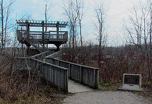
MacGregor Point Provincial Park
Provincial park in Ontario, Canada
Distance: Approx. 5381 meters
Latitude and longitude: 44.40861111,-81.44583333
MacGregor Point Provincial Park is a park located on Lake Huron, off of Bruce Road 33 near Port Elgin, Ontario, Canada. The varied habitat found within the park includes a seven-kilometre stretch of coast, coastal wetlands, forests, and dunes. Although the beaches in the park can be used for swimming, better beaches can be found at Port Elgin or nearby Inverhuron Provincial Park.

Port Elgin, Ontario
Community in Ontario, Canada
Distance: Approx. 616 meters
Latitude and longitude: 44.43388889,-81.39277778
Port Elgin is a community in the town of Saugeen Shores, Ontario, Canada. Its location is in the traditional territory of the Saugeen Ojibway Nation. Originally named Normanton the town was renamed Port Elgin when it was incorporated in 1874, after James Bruce, 8th Earl of Elgin, a former Governor General of the Province of Canada.
Port Elgin (Pryde Field) Airport
Airport in Ontario, Canada
Distance: Approx. 3122 meters
Latitude and longitude: 44.45888889,-81.37972222
Port Elgin (Pryde Field) Airport, formerly TC LID: CPG6, was located 1.5 NM (2.8 km; 1.7 mi) north of Port Elgin, Ontario, Canada.

Port Elgin Airport
Airport in Port Elgin, Ontario
Distance: Approx. 2873 meters
Latitude and longitude: 44.41527778,-81.41444444
Port Elgin Airport (TC LID: CNL4) is located 1.3 nautical miles (2.4 km; 1.5 mi) southwest of Port Elgin, Ontario, Canada.
Southampton Aerodrome
Airport in Southampton, Ontario
Distance: Approx. 8058 meters
Latitude and longitude: 44.49388889,-81.33527778
Southampton Aerodrome (TC LID: CPF7) is an aerodome located 1.4 nautical miles (2.6 km; 1.6 mi) east of Southampton, Ontario, Canada.
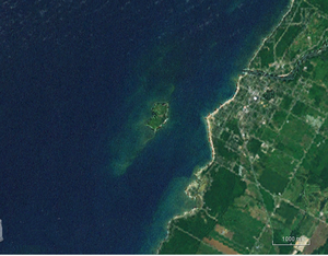
Chantry Island (Ontario)
Distance: Approx. 6677 meters
Latitude and longitude: 44.4898,-81.4039
Chantry Island is a small island in Lake Huron, south of the mouth of the Saugeen River and approximately a kilometre off the shores of the town of Southampton, Ontario. It is approximately 19 hectares (47 acres) in size and is a migratory bird sanctuary. Since the sanctuary territory extends 183 metres into the water surrounding the island, the total official area is listed as 63 hectares (160 acres).
Port Elgin and North Shore Railroad
Distance: Approx. 1860 meters
Latitude and longitude: 44.4429,-81.4027
The Port Elgin and North Shore Railroad was a 16 in (406 mm) miniature heritage railway in Port Elgin, Ontario. The history of the Port Elgin and North Shore Railroad dates back to the early 1970s when a local tool and die maker endeavored to establish a park train tourist attraction in Port Elgin's North Shore Park. This gentleman's name is Doug Schlenker and with the help of his father, Doug started building the little railroad in 1971.
Saugeen Golf Club
Golf club in Ontario, Canada
Distance: Approx. 5095 meters
Latitude and longitude: 44.4695,-81.3509
The Saugeen Golf Club is located between the tourist towns of Southampton and Port Elgin in Bruce County, Ontario, Canada, situated on Lake Huron. The club was founded in 1925 and consists of 27 holes, split into three separate nine-hole courses known as Legacy, Sunrise and Sunset.

Chantry Island Lighthouse
Lighthouse
Distance: Approx. 6599 meters
Latitude and longitude: 44.48938,-81.40194
The Chantry Island Lighthouse, officially known as Chantry Island Lightstation Tower, is a lightstation on Chantry Island, off the coast of Southampton, Ontario in Lake Huron. It was constructed in the years 1855 through to 1859, by John Brown of Thorold, Ontario, under the authority of the Province of Canada and is recognized as one of the six Imperial Towers. Virtually identical, they were completed in 1858-1859 on Lake Huron and Georgian Bay and are among the few lighthouses on the Great Lakes made of cut limestone and granite (not brick, metal, wood or concrete).
Weather in this IP's area
clear sky
17 Celsius
17 Celsius
16 Celsius
18 Celsius
1016 hPa
88 %
1016 hPa
992 hPa
10000 meters
2.52 m/s
4.37 m/s
116 degree
07:08:35
19:30:34