Country:
Region:
City:
Latitude and Longitude:
Time Zone:
Postal Code:
IP information under different IP Channel
ip-api
Country
Region
City
ASN
Time Zone
ISP
Blacklist
Proxy
Latitude
Longitude
Postal
Route
IPinfo
Country
Region
City
ASN
Time Zone
ISP
Blacklist
Proxy
Latitude
Longitude
Postal
Route
MaxMind
Country
Region
City
ASN
Time Zone
ISP
Blacklist
Proxy
Latitude
Longitude
Postal
Route
Luminati
Country
Region
il
City
hamilton
ASN
Time Zone
America/Chicago
ISP
MTCCOMM
Latitude
Longitude
Postal
db-ip
Country
Region
City
ASN
Time Zone
ISP
Blacklist
Proxy
Latitude
Longitude
Postal
Route
ipdata
Country
Region
City
ASN
Time Zone
ISP
Blacklist
Proxy
Latitude
Longitude
Postal
Route
Popular places and events near this IP address

Hancock County, Illinois
County in Illinois, United States
Distance: Approx. 6315 meters
Latitude and longitude: 40.4,-91.17
Hancock County is a county in the U.S. state of Illinois. According to the 2020 census, it has a population of 17,620. Its county seat is Carthage, and its largest city is Hamilton.

Bentley, Illinois
Town in Illinois, United States
Distance: Approx. 7959 meters
Latitude and longitude: 40.34361111,-91.11194444
Bentley (formerly Sutton) is an incorporated town in southeast Hancock County, Illinois, United States. The population was 30 at the 2020 census.

Carthage, Illinois
City in Illinois, United States
Distance: Approx. 3003 meters
Latitude and longitude: 40.41444444,-91.13333333
Carthage is a city in and the county seat of Hancock County, Illinois, United States. Its population was 2,490 as of the 2020 census. Carthage is best known for being the site of the 1844 death of Joseph Smith, who founded the Latter Day Saint movement.

Ferris, Illinois
Village in Illinois, United States
Distance: Approx. 8583 meters
Latitude and longitude: 40.46888889,-91.16944444
Ferris is a village in Hancock County, Illinois, United States. The population was 127 at the 2020 census.

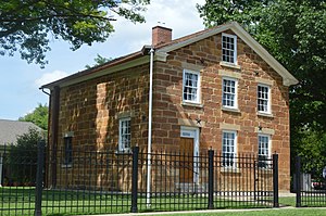
Carthage Jail
United States historic place
Distance: Approx. 3473 meters
Latitude and longitude: 40.41572,-91.13884
Carthage Jail is a historic building in Carthage, Illinois, listed on the National Register of Historic Places (NRHP). It was built in 1839 and is best known as the location of the 1844 killing of Joseph Smith, founder of the Latter Day Saint movement, and his brother Hyrum, by a mob of approximately 150 men. It was added to the NRHP in 1973 and is operated by the Church of Jesus Christ of Latter-day Saints (LDS Church) as a historic site with an adjacent visitors' center.

Carthage Township, Hancock County, Illinois
Township in Illinois, United States
Distance: Approx. 697 meters
Latitude and longitude: 40.415,-91.08972222
Carthage Township is one of twenty-four townships in Hancock County, Illinois, USA. As of the 2020 census, its population was 2,947 and it contained 1,466 housing units.

Prairie Township, Hancock County, Illinois
Township in Illinois, United States
Distance: Approx. 9334 meters
Latitude and longitude: 40.42444444,-91.20722222
Prairie Township is one of twenty-four townships in Hancock County, Illinois, USA. As of the 2020 census, its population was 382 and it contained 186 housing units. It was formed from Montebello and Carthage townships on September 12, 1854.
WCAZ
Radio station in Carthage, Illinois
Distance: Approx. 6167 meters
Latitude and longitude: 40.40861111,-91.17027778
WCAZ (1510 kHz) is a farm/country formatted AM radio station, licensed to Carthage, Illinois. Because the station shares the same frequency as clear-channel station WLAC in Nashville, Tennessee, WCAZ broadcasts only during the daytime. However, its FM translator, W256DZ on 99.1 MHz, also provides nighttime operation.
WCAZ (990 AM)
Radio station in Carthage, Illinois
Distance: Approx. 6157 meters
Latitude and longitude: 40.40876,-91.17017
WCAZ (990 AM, "Talk 990") was formerly a commercial radio station, whose operating license was cancelled by the Federal Communications Commission (FCC) on April 21, 2017. First licensed in May 1922, WCAZ had been one of the oldest radio stations in the United States. At the time of its deletion the station was licensed to the Ralla Broadcasting Company in Carthage, Illinois, and featured a talk/personality format.
Illini West High School
High school in Carthage, Illinois
Distance: Approx. 3189 meters
Latitude and longitude: 40.42099,-91.13449
Illini West High School (IWHS) is a public high school in Carthage, Illinois, United States. IWHS serves a mostly rural area that includes most of northeastern Hancock County and extends into parts of Henderson and McDonough Counties, covering the cities of Carthage, Dallas City, and La Harpe, and the village of Ferris. The campus is located 25 miles (40 km) west of Macomb, Illinois, and has a student body of 332 students in grades 9–12 as of the 2017–18 school year.

Carthage Courthouse Square Historic District (Carthage, Illinois)
Historic district in Illinois, United States
Distance: Approx. 3195 meters
Latitude and longitude: 40.41305556,-91.13555556
The Carthage Courthouse Square Historic District is a historic district encompassing the courthouse square of Carthage, Hancock County, Illinois. The district includes 52 buildings, 42 of which are considered contributing to the district's historic character. The 1908 Hancock County Courthouse, a three-story limestone Beaux-Arts building, is the centerpiece of the district.
Middle Creek, Illinois
Unincorporated community in Illinois, United States
Distance: Approx. 7568 meters
Latitude and longitude: 40.37277778,-91.02722222
Middle Creek is an unincorporated community in Carthage Township, Hancock County, Illinois, United States. The community is located along County Route 28 6.5 miles (10.5 km) east-southeast of Carthage.
Weather in this IP's area
clear sky
21 Celsius
19 Celsius
20 Celsius
21 Celsius
1026 hPa
19 %
1026 hPa
1004 hPa
10000 meters
5.05 m/s
6.87 m/s
174 degree
07:18:51
18:19:41