Country:
 USA
USARegion:
City:
Latitude and Longitude:
Time Zone:
Postal Code:
IP information under different IP Channel
ip-api
Country
Region
City
ASN
Time Zone
ISP
Blacklist
Proxy
Latitude
Longitude
Postal
Route
IPinfo
Country
Region
City
ASN
Time Zone
ISP
Blacklist
Proxy
Latitude
Longitude
Postal
Route
MaxMind
Country
Region
City
ASN
Time Zone
ISP
Blacklist
Proxy
Latitude
Longitude
Postal
Route
Luminati
Country
USRegion
sc
City
sumter
ASN
Time Zone
America/New_York
ISP
FTC-INET
Latitude
Longitude
Postal
db-ip
Country
Region
City
ASN
Time Zone
ISP
Blacklist
Proxy
Latitude
Longitude
Postal
Route
ipdata
Country
Region
City
ASN
Time Zone
ISP
Blacklist
Proxy
Latitude
Longitude
Postal
Route
Popular places and events near this IP address

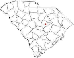
Sumter County, South Carolina
County in South Carolina, United States
Distance: Approx. 4776 meters
Latitude and longitude: 33.92,-80.38
Sumter County is a county located in the U.S. state of South Carolina. As of the 2020 census, the population was 105,556. Its county seat is Sumter.
Cane Savannah, South Carolina
CDP in South Carolina, United States
Distance: Approx. 3274 meters
Latitude and longitude: 33.89222222,-80.43722222
Cane Savannah is a census-designated place (CDP) in Sumter County, South Carolina, United States. The population was 1,452 at the 2000 census. It is included in the Sumter, South Carolina Metropolitan Statistical Area.
Lakewood, South Carolina
CDP in South Carolina, United States
Distance: Approx. 5929 meters
Latitude and longitude: 33.85055556,-80.35222222
Lakewood is a census-designated place (CDP) in Sumter County, South Carolina, United States. The population was 2,603 at the 2000 census. It is included in the Sumter, South Carolina Metropolitan Statistical Area.

Millwood, South Carolina
CDP in South Carolina, United States
Distance: Approx. 3704 meters
Latitude and longitude: 33.91222222,-80.38722222
Millwood is a census-designated place (CDP) in Sumter County, South Carolina, United States. The population was 885 at the 2000 census. It is included in the Sumter, South Carolina Metropolitan Statistical Area.
South Sumter, South Carolina
CDP in South Carolina, United States
Distance: Approx. 6475 meters
Latitude and longitude: 33.89444444,-80.33555556
South Sumter is a census-designated place (CDP) in Sumter County, South Carolina, United States. The population was 3,365 at the 2000 census. It is included in the Sumter, South Carolina Metropolitan Statistical Area.
Swan Lake Iris Gardens
Distance: Approx. 5189 meters
Latitude and longitude: 33.9195559,-80.3707367
Swan Lake Iris Gardens is a public park located in Sumter, South Carolina. It is currently the only public park in the United States to have all eight species of swans—including Royal white mutes, Black Necks, Coscorobas, Whoopers, Black Australians, Whistlers, Bewicks, and Trumpeters.

University of South Carolina Sumter
Distance: Approx. 6328 meters
Latitude and longitude: 33.93305556,-80.37388889
The University of South Carolina Sumter (USC Sumter) is a public college in Sumter, South Carolina. It is part of the University of South Carolina System and one of the four regional USC campuses which make up Palmetto College. It only awards associate degrees and has approximately 1,500 students.
St. Francis Xavier High School (Sumter, South Carolina)
Private school in Sumter, South Carolina, United States
Distance: Approx. 5965 meters
Latitude and longitude: 33.91916667,-80.3575
St. Francis Xavier High School was a private, Roman Catholic high school in Sumter, South Carolina, United States. It is run independently of the Roman Catholic Diocese of Charleston.
Palmetto Tennis Center
Distance: Approx. 6486 meters
Latitude and longitude: 33.93666667,-80.37972222
Palmetto Tennis Center (PTC) is a National Tennis Court in Palmetto Park in Sumter, South Carolina. It is the largest tennis center in the state. PTC has 18 lit hard courts as well as six Deco-Turf courts.
Battle of Dingle's Mill
Battle of the American Civil War
Distance: Approx. 6337 meters
Latitude and longitude: 33.87583333,-80.33583333
The Battle of Dingle's Mill was an American Civil War battle that took place near Sumterville, South Carolina.
Sumter High School
Public high school in Sumter, South Carolina, United States
Distance: Approx. 1998 meters
Latitude and longitude: 33.8973797,-80.3928597
Sumter High School is a co-educational four-year public high school serving grades 9 through 12 in Sumter School District located in the south side of Sumter, South Carolina, United States. With an enrollment of approximately 2,400 students, Sumter High is the second-largest high school in the Midlands of South Carolina and the fifth largest in the state of South Carolina. In 2004 Sumter High School was designated The Model School for SC and one of thirty model schools nationwide by a national organization funded by the Bill and Melinda Gates Foundation.
Lakewood High School (Sumter, South Carolina)
Public high school in Sumter, South Carolina, United States
Distance: Approx. 5466 meters
Latitude and longitude: 33.8532,-80.3561
Lakewood High School is a co-educational four-year public high school in Sumter, South Carolina, serving grades 9 through 12. Lakewood is one of only three public high schools in the Sumter School District and enrolls between 1,100 to 1,300 students each year from the southern half of Sumter County. The mascot of Lakewood High School is the Gator, chosen for Alligator Branch, a nearby stream.
Weather in this IP's area
clear sky
25 Celsius
26 Celsius
24 Celsius
26 Celsius
1011 hPa
76 %
1011 hPa
1005 hPa
10000 meters
07:07:59
19:22:35