Country:
 USA
USARegion:
City:
Latitude and Longitude:
Time Zone:
Postal Code:
IP information under different IP Channel
ip-api
Country
Region
City
ASN
Time Zone
ISP
Blacklist
Proxy
Latitude
Longitude
Postal
Route
IPinfo
Country
Region
City
ASN
Time Zone
ISP
Blacklist
Proxy
Latitude
Longitude
Postal
Route
MaxMind
Country
Region
City
ASN
Time Zone
ISP
Blacklist
Proxy
Latitude
Longitude
Postal
Route
Luminati
Country
USRegion
sc
City
sumter
ASN
Time Zone
America/New_York
ISP
FTC-INET
Latitude
Longitude
Postal
db-ip
Country
Region
City
ASN
Time Zone
ISP
Blacklist
Proxy
Latitude
Longitude
Postal
Route
ipdata
Country
Region
City
ASN
Time Zone
ISP
Blacklist
Proxy
Latitude
Longitude
Postal
Route
Popular places and events near this IP address

Cherryvale, South Carolina
CDP in South Carolina, United States
Distance: Approx. 7037 meters
Latitude and longitude: 33.95527778,-80.46027778
Cherryvale is a census-designated place (CDP) in Sumter County, South Carolina, United States. The population was 2,461 at the 2000 census. It is included in the Sumter, South Carolina Metropolitan Statistical Area.
Dalzell, South Carolina
CDP in South Carolina, United States
Distance: Approx. 3369 meters
Latitude and longitude: 34.01972222,-80.42972222
Dalzell is a census-designated place (CDP) in Sumter County, South Carolina, United States. The population was 3,175 at the 2020 census. It is included in the Sumter, South Carolina Metropolitan Statistical Area.

Oakland, South Carolina
CDP in South Carolina, United States
Distance: Approx. 4555 meters
Latitude and longitude: 33.98805556,-80.49944444
Oakland is a census-designated place (CDP) in Sumter County, South Carolina, United States. The population was 1,272 at the 2000 census. It is included in the Sumter, South Carolina Metropolitan Statistical Area.
Stateburg, South Carolina
CDP in South Carolina, United States
Distance: Approx. 6998 meters
Latitude and longitude: 33.97861111,-80.525
Stateburg is a census-designated place (CDP) in the High Hills of Santee in Sumter County, South Carolina, United States. The population was 1,380 at the 2010 census. It is included in the Sumter, South Carolina Metropolitan Statistical Area.

Shaw Air Force Base
US Air Force base at Sumter, South Carolina, United States
Distance: Approx. 5073 meters
Latitude and longitude: 33.97305556,-80.47277778
Shaw Air Force Base (Shaw AFB) (IATA: SSC, ICAO: KSSC, FAA LID: SSC) is a United States Air Force (USAF) base located approximately 8.4 miles (13.5 km) west-northwest of downtown Sumter, South Carolina. It is one of the largest military bases operated by the United States, and is under the jurisdiction of USAF Air Combat Command (ACC). The 20th Fighter Wing (20th FW) is the host unit.

Stateburg Historic District
Historic district in South Carolina, United States
Distance: Approx. 6941 meters
Latitude and longitude: 33.97027778,-80.51416667
The Stateburg Historic District is a historic district in Stateburg, in the High Hills of Santee area near Sumter, South Carolina in the United States. It includes two National Historic Landmarks, Borough House Plantation and the Church of the Holy Cross, and at least eight contributing properties within its boundaries. On February 24, 1971, it was added to the National Register of Historic Places.
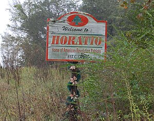
Horatio, South Carolina
Place in South Carolina, United States
Distance: Approx. 9199 meters
Latitude and longitude: 34.02138889,-80.56583333
Horatio is an unincorporated community in the High Hills of Santee area in western Sumter County, South Carolina, United States. It lies on Horatio Road west of South Carolina Highway 261 north of Stateburg and is the location of the Lenoir Store, which is listed on the National Register of Historic Places. The Horatio post office, zip code 29168, is located inside the Lenoir Store at 3240 Horatio Road.
High Hills of Santee Baptist Church
Historic church in South Carolina, United States
Distance: Approx. 7286 meters
Latitude and longitude: 33.98508,-80.534224
High Hills of Santee Baptist Church is an historic Southern Baptist church located in the High Hills of Santee in Stateburg, near Dalzell in Sumter County, South Carolina. Its congregation was founded in 1772 and the present church was built in 1848. Its first pastor was Richard Furman, who went on to become one of South Carolina's most influential ministers.
High Hills of Santee
Distance: Approx. 8460 meters
Latitude and longitude: 33.984,-80.548
The High Hills of Santee, sometimes known as the High Hills of the Santee, is a long, narrow hilly region in the western part of Sumter County, South Carolina. It has been called "one of the state's most famous areas". The High Hills of Santee region lies north of the Santee River and east of the Wateree River, one of the two rivers that join to form the Santee.
Claremont County, South Carolina
Distance: Approx. 7053 meters
Latitude and longitude: 34.05,-80.4
Claremont County was a county in east central South Carolina. Its county seat was Stateburg. It lasted from its creation in 1785, when it was created from the Camden District, until it was absorbed into the newly created Sumter District in 1800.
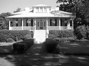
Orange Grove (Dalzell, South Carolina)
Historic house in South Carolina, United States
Distance: Approx. 4067 meters
Latitude and longitude: 34.045,-80.43611111
Orange Grove, also known as the Gaillard-Colclough House, is an historic 39.9-acre (161,000 m2) plantation and its plantation house at Gaillard's Crossroads, (intersection of Peach Orchard Road and Black River Road), north of Dalzell, South Carolina. It was added to the National Register of Historic Places on August 19, 1993. Originally built in 1851 in a South Carolina Lowcountry vernacular style of architecture, the house was seriously damaged by a tornado on April 30, 1924, and was rebuilt so that it now appears as a "raised cottage with a Prairie or Craftsman roof." The plantation house's main axis runs NW-SE, with the façade on the SE face.
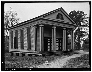
Ellerbe's Mill
United States historic place
Distance: Approx. 8225 meters
Latitude and longitude: 34.06944444,-80.53055556
Ellerbe's Mill, also known as Millvale, is a historic grist mill complex located near Rembert, Sumter County, South Carolina. The mill was built about 1830, and is a 2 1/2-story pine clapboard building mounted on wooden pilings situated on a 90-acre millpond. Also located on the property is the associated store (1910); the two-story, frame Victorian style main house (c.
Weather in this IP's area
clear sky
24 Celsius
25 Celsius
24 Celsius
25 Celsius
1011 hPa
85 %
1011 hPa
1001 hPa
10000 meters
07:08:12
19:22:51