Country:
Region:
City:
Latitude and Longitude:
Time Zone:
Postal Code:
IP information under different IP Channel
ip-api
Country
Region
City
ASN
Time Zone
ISP
Blacklist
Proxy
Latitude
Longitude
Postal
Route
Luminati
Country
Region
sc
City
sumter
ASN
Time Zone
America/New_York
ISP
FTC-INET
Latitude
Longitude
Postal
IPinfo
Country
Region
City
ASN
Time Zone
ISP
Blacklist
Proxy
Latitude
Longitude
Postal
Route
db-ip
Country
Region
City
ASN
Time Zone
ISP
Blacklist
Proxy
Latitude
Longitude
Postal
Route
ipdata
Country
Region
City
ASN
Time Zone
ISP
Blacklist
Proxy
Latitude
Longitude
Postal
Route
Popular places and events near this IP address

Clarendon County, South Carolina
County in South Carolina, United States
Distance: Approx. 4692 meters
Latitude and longitude: 33.66,-80.22
Clarendon County is a county located below the fall line in the Coastal Plain region of U.S. state of South Carolina. As of the 2020 census, its population was 31,144. Its county seat is Manning.

Manning, South Carolina
City in South Carolina, United States
Distance: Approx. 8540 meters
Latitude and longitude: 33.695,-80.21083333
Manning is a city in and the county seat of Clarendon County, South Carolina, United States. The population was 3,245 as of the 2010 census, with an estimated population in 2018 of 3,941. It was named after former South Carolina governor John Laurence Manning.
Manning High School
Public high school in Manning, , South Carolina, United States
Distance: Approx. 9299 meters
Latitude and longitude: 33.7018293,-80.2117466
Manning High School is one of two high schools in Manning, South Carolina, United States. It is part of the Clarendon County's Clarendon County School District 2 and serves grades 9–12. Manning High School has approximately 870 students instructed by 39 teachers.

Manning Library
United States historic place
Distance: Approx. 9066 meters
Latitude and longitude: 33.69972222,-80.21055556
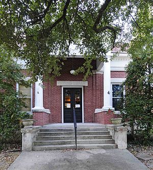
Manning Library, also known as Clarendon County Public Library and Hannah Levi Memorial Library, is a historic library building located at Manning, Clarendon County, South Carolina. It was built in 1909–1910, and is a one-story, brick, Classical Revival style structure is set on a raised basement. The front façade features a pedimented Roman Doric order portico projecting from the central bay.

Alderman's 20 Stores in One
United States historic place
Distance: Approx. 7675 meters
Latitude and longitude: 33.68722222,-80.21055556
Alderman's 20 Stores in One, also known as The Belk Building, is a historic commercial building located at Manning, Clarendon County, South Carolina. It was built in 1919, and is a two-story red brick building or two-part commercial block with a flat roof and parapets. The main façade of the building features a metal entablature supported by brackets and ornamented by recessed panels.

Davis House (Manning, South Carolina)
Historic house in South Carolina, United States
Distance: Approx. 4000 meters
Latitude and longitude: 33.6525,-80.22583333
Davis House (also known as El Recuerdo) is a historic plantation house located near Manning, Clarendon County, South Carolina.

Manning Commercial Historic District
Historic district in South Carolina, United States
Distance: Approx. 8571 meters
Latitude and longitude: 33.69527778,-80.21055556
Manning Commercial Historic District is a national historic district located at Manning, Clarendon County, South Carolina. The district encompasses 46 contributing buildings and 1 contributing object in the central business district of Manning, county seat for Clarendon County. Manning's downtown is dominated by its 1909 Neo-Classical, red brick courthouse set at the center of a landscaped courthouse square.

Davis Station, South Carolina
Unincorporated community in South Carolina, United States
Distance: Approx. 5108 meters
Latitude and longitude: 33.60277778,-80.26444444
Davis Station is an unincorporated community in Clarendon County, South Carolina, United States. The community is 7.1 miles (11.4 km) south-southwest of Manning. Davis Station has a post office with ZIP code 29041.
Wyboo, South Carolina
Census-designated place in South Carolina, United States
Distance: Approx. 6835 meters
Latitude and longitude: 33.55694444,-80.21527778
Wyboo is a lakeside community and census-designated place (CDP) in Clarendon County, South Carolina, United States. It was first listed as a CDP prior to the 2020 census with a population of 3,661. The CDP is in southern Clarendon County, on both sides of Wyboo Swamp, an arm of Lake Marion, the largest lake in South Carolina.
Jordan, South Carolina
Unincorporated community in South Carolina, United States
Distance: Approx. 1400 meters
Latitude and longitude: 33.60611111,-80.20888889
Jordan is an unincorporated community in Clarendon County, South Carolina, United States. The community is located along South Carolina Highway 260, 6.3 miles (10.1 km) south of Manning. Jordan does not have a post office.
Weather in this IP's area
clear sky
14 Celsius
14 Celsius
13 Celsius
17 Celsius
1025 hPa
88 %
1025 hPa
1021 hPa
10000 meters
06:47:33
17:21:59