Country:
Region:
City:
Latitude and Longitude:
Time Zone:
Postal Code:
IP information under different IP Channel
ip-api
Country
Region
City
ASN
Time Zone
ISP
Blacklist
Proxy
Latitude
Longitude
Postal
Route
Luminati
Country
ASN
Time Zone
America/Chicago
ISP
WEBNX
Latitude
Longitude
Postal
IPinfo
Country
Region
City
ASN
Time Zone
ISP
Blacklist
Proxy
Latitude
Longitude
Postal
Route
db-ip
Country
Region
City
ASN
Time Zone
ISP
Blacklist
Proxy
Latitude
Longitude
Postal
Route
ipdata
Country
Region
City
ASN
Time Zone
ISP
Blacklist
Proxy
Latitude
Longitude
Postal
Route
Popular places and events near this IP address

Weber County, Utah
County in Utah, United States
Distance: Approx. 6074 meters
Latitude and longitude: 41.3,-111.92
Weber County ( WEE-bər) is a county in the U.S. state of Utah. As of the 2020 census, the population was 262,223, making it Utah's fourth-most populous county. Its county seat and largest city is Ogden, the home of Weber State University.

Farr West, Utah
City in Utah, United States
Distance: Approx. 3374 meters
Latitude and longitude: 41.30166667,-112.03166667
Farr West is a city on the northern edge of Weber County, Utah. The population was 7,691 at the 2020 census, up from 5,928 at the 2010 census. It is part of the Ogden–Clearfield metropolitan area.

Harrisville, Utah
City in Utah, United States
Distance: Approx. 2299 meters
Latitude and longitude: 41.28666667,-111.995
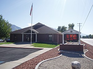
Harrisville is a city in Weber County, Utah, United States. The population was 5,567 at the 2010 census. It is part of the Ogden–Clearfield, Utah Metropolitan Statistical Area.

Marriott-Slaterville, Utah
City in Utah, United States
Distance: Approx. 6244 meters
Latitude and longitude: 41.25555556,-112.02111111
Marriott-Slaterville is a city in Weber County, Utah, United States. The population was 1,701 at the 2010 census. It is part of the Ogden–Clearfield, Utah Metropolitan Statistical Area.

North Ogden, Utah
City in Utah, United States
Distance: Approx. 2870 meters
Latitude and longitude: 41.31222222,-111.95833333
North Ogden is a city in Weber County, Utah, United States. The population was 20,916 at the 2020 census. North Ogden is on SR-235, three miles north of Ogden.

Pleasant View, Utah
City in Utah, United States
Distance: Approx. 2111 meters
Latitude and longitude: 41.32555556,-111.99833333
Pleasant View is a city on the northern edge of Weber County, Utah, United States. The population was 7,979 at the 2010 census. It is part of the Ogden–Clearfield, Utah Metropolitan Statistical Area.

Ben Lomond Mountain (Utah)
Mountain in the American state of Utah
Distance: Approx. 6775 meters
Latitude and longitude: 41.3632737,-111.9604982
Ben Lomond, just north of Ogden, Utah, is a peak in the northern portion of the Wasatch Mountains. A popular trail passes over its summit (elevation 9,716 feet (2,961 m)), accessible from four different trailheads to the north, south, and east. It is often referred to by locals as Ben Lomond Peak, Mt.
Golden Spike Arena
Distance: Approx. 3556 meters
Latitude and longitude: 41.27555556,-111.99777778
The Golden Spike Arena is a 6,500-seat multi-purpose arena in Ogden, Utah. The arena hosts local concerts, trade shows and sporting events for the area. The Golden Spike Arena was the home to the Ogden Knights of the American Indoor Football Association.

Defense Depot Ogden
U.S. military installation in Ogden, Utah, US
Distance: Approx. 4850 meters
Latitude and longitude: 41.26396389,-111.99918611
Defense Depot Ogden was a U.S. military installation located in Ogden, Utah, United States. It encompassed 1,139 acres (5 km2) with its southwest corner located on 12th Street (1200 South) and Tomlinson Road (1200 West). Its eastern border is the old Utah Northern Railroad, now owned by the Union Pacific Railroad.
Weber High School
High school in Pleasant View, Utah
Distance: Approx. 1896 meters
Latitude and longitude: 41.32333333,-111.98472222
Weber High School is a Utah secondary school located in Pleasant View, Utah, about five miles north of Ogden. It serves the residents of Pleasant View, North Ogden, Harrisville, Huntsville, Eden, and Liberty. It is part of the Weber School District and includes grades 10–12.
Pleasant View station
Distance: Approx. 1552 meters
Latitude and longitude: 41.3075,-112.01055556
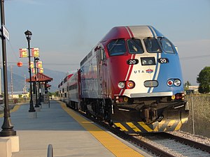
Pleasant View is a closed commuter rail station in Pleasant View, Utah, formerly served by the Utah Transit Authority's (UTA) FrontRunner train. Located approximately 6 miles north of the Ogden station, Pleasant View was the northernmost station along the FrontRunner line prior to its closure on August 10, 2018, when service north of Ogden was suspended. It was also the least-used station on FrontRunner, with few daily riders.

Ogden–Weber Technical College
Technical college in Ogden, Utah, US
Distance: Approx. 5306 meters
Latitude and longitude: 41.26416667,-111.96472222
Ogden–Weber Technical College (also referred to as OTECH, Ogden-Weber Tech or OWTC) is a public technical college in Ogden, Utah. It is one of the largest of the eight technical colleges within the Utah System of Higher Education (USHE). The college offers open-entry, open-exit, competency-based education targeted at technical skills and job placement (also called career and technical education).
Weather in this IP's area
overcast clouds
4 Celsius
2 Celsius
3 Celsius
5 Celsius
1010 hPa
71 %
1010 hPa
861 hPa
10000 meters
1.34 m/s
2.68 m/s
22 degree
100 %
07:20:37
17:06:15
