173.231.108.66 - IP Lookup: Free IP Address Lookup, Postal Code Lookup, IP Location Lookup, IP ASN, Public IP
Country:
Region:
City:
Location:
Time Zone:
Postal Code:
ISP:
ASN:
language:
User-Agent:
Proxy IP:
Blacklist:
IP information under different IP Channel
ip-api
Country
Region
City
ASN
Time Zone
ISP
Blacklist
Proxy
Latitude
Longitude
Postal
Route
db-ip
Country
Region
City
ASN
Time Zone
ISP
Blacklist
Proxy
Latitude
Longitude
Postal
Route
IPinfo
Country
Region
City
ASN
Time Zone
ISP
Blacklist
Proxy
Latitude
Longitude
Postal
Route
IP2Location
173.231.108.66Country
Region
quebec
City
saint-jerome
Time Zone
America/Montreal
ISP
Language
User-Agent
Latitude
Longitude
Postal
ipdata
Country
Region
City
ASN
Time Zone
ISP
Blacklist
Proxy
Latitude
Longitude
Postal
Route
Popular places and events near this IP address

Saint-Jérôme
City in Quebec, Canada
Distance: Approx. 438 meters
Latitude and longitude: 45.78333333,-74
Saint-Jérôme (French pronunciation: [sɛ̃ ʒeʁom]) (2021 population 80,213) is a suburban city located about 45 kilometres (28 mi) northwest of Montreal on the Rivière du Nord. It is part of the North Shore sector of Greater Montreal. It is a gateway to the Laurentian Mountains and its resorts via the Autoroute des Laurentides.

La Rivière-du-Nord Regional County Municipality
Regional county municipality in Quebec, Canada
Distance: Approx. 4173 meters
Latitude and longitude: 45.81666667,-74.01666667
La Rivière-du-Nord (French pronunciation: [la ʁivjɛʁ dy nɔʁ]; The Rivière-du-Nord or The River of the North) is a regional county municipality in the Laurentides region of Quebec, Canada. The seat is in Saint-Jérôme. It is named for the river that runs through it, the Rivière du Nord.
Melançon Arena
Distance: Approx. 608 meters
Latitude and longitude: 45.779466,-73.995863
Melançon Arena was an indoor arena located in Saint-Jérôme, Quebec. It was once home to the Saint-Jérôme Alouettes of the Quebec Junior Hockey League mid 1950s to 1969 and Quebec Major Junior Hockey League 1969 to 1972. It was also home to the Saint-Jérôme Panthers of the Quebec Junior AAA Hockey League from 1988 to 2017.

Saint-Jérôme station
Railway station in Quebec, Canada
Distance: Approx. 832 meters
Latitude and longitude: 45.77333333,-73.99972222
Saint-Jérôme station (French pronunciation: [sɛ̃ ʒeʁom]) is an intermodal transit station in Saint-Jérôme, Quebec, Canada. It serves Exo and intercity buses as well as Exo commuter rail trains on the Saint-Jérôme line.

Roman Catholic Diocese of Saint-Jérôme–Mont-Laurier
Catholic ecclesiastical territory
Distance: Approx. 281 meters
Latitude and longitude: 45.77805556,-74.00194444
The Roman Catholic Diocese of Saint-Jérôme (Latin: Dioecesis Sancti Hieronymi Terraebonae) is a Latin rite suffragan of the Archdiocese of Montréal. Its cathedral episcopal see is Cathédrale Saint-Jérôme, dedicated to Saint Jerome (Hieronumus), in Saint-Jérôme, Quebec.
Cégep de Saint-Jérôme
Public college in Saint-Jérôme, Quebec
Distance: Approx. 275 meters
Latitude and longitude: 45.7785,-74.001175
The CEGEP of Saint-Jérôme (French: Cégep de Saint-Jérôme (CSTJ)) is a post-secondary education school in the Laurentides region of province of Quebec, Canada. There are three campuses affiliated to the CSTJ, the main one is located at Saint-Jérôme; the two others are in Mont-Tremblant and Mont-Laurier.
CFND-FM
Radio station in Saint-Jérôme, Quebec
Distance: Approx. 1212 meters
Latitude and longitude: 45.78444444,-73.98916667
CFND-FM is a French language community campus radio station that operates at 101.9 FM in Saint-Jérôme, Quebec, Canada. Owned by Amie du Quartier, the station received CRTC approval in 2007. The radio station is based at the École Notre-Dame, a primary school in Saint-Jérôme.
Terrebonne County, Quebec
Distance: Approx. 1559 meters
Latitude and longitude: 45.77,-73.99
Terrebonne County (French: Comté de Terrebonne, pronounced [kɔ̃te də tɛʁbɔn]) is a historical county in the Laurentides region of Quebec, Canada. Its county seat and main city was Saint-Jérôme. In the early 1980s Quebec's counties were abolished and replaced by regional county municipalities.
Carrefour du Nord
Shopping mall in Saint-Jérôme, Quebec, Canada
Distance: Approx. 1859 meters
Latitude and longitude: 45.79361111,-74.01805556
Carrefour du Nord is a regional shopping mall in Saint-Jérôme, Quebec, Canada. It opened on August 11, 1976 with Steinberg's, Dominion, Kmart and 76 stores. Sears inaugurated the following year.
Rinfret, Quebec
Railway junction in Quebec, Canada
Distance: Approx. 3290 meters
Latitude and longitude: 45.75167,-73.99306
Rinfret is a railway junction in the city of Saint-Jérôme in the Canadian province of Quebec. It is located at mile 36.4 of the Montfort Spur of the Quebec Gatineau Railway. Its latitude and longitude are 45.75167°N 73.99306°W / 45.75167; -73.99306, also written as 45°45′06″N 73°59′35″W. One reference states that one of the lines that meet at this junction was built by the Great Northern Railway of Canada, which was later acquired by Canadian Northern Railway.

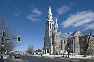
St. Jerome's Cathedral (Saint-Jérôme)
Church in Quebec, Canada
Distance: Approx. 259 meters
Latitude and longitude: 45.7781,-74.0025
The Cathedral of St. Jerome (French: Cathédrale de Saint-Jérôme) is the seat of the Roman Catholic Diocese of Saint-Jérôme-Mont-Laurier in Canada. The cathedral church is located at 355 Rue St-Georges in Saint-Jérôme, Quebec.
École polyvalente Saint-Jérôme
School
Distance: Approx. 1192 meters
Latitude and longitude: 45.7883,-73.9934
École polyvalente Saint-Jérôme (EPSJ) is a public Francophone secondary school in Saint-Jérôme, Quebec. It is a part of the Commission scolaire de la Rivière-du-Nord. It serves sections of Saint-Jérôme, including Mirabel, Prévost, and Saint-Colomban.
Weather in this IP's area
broken clouds
-7 Celsius
-10 Celsius
-9 Celsius
-7 Celsius
1019 hPa
63 %
1019 hPa
1001 hPa
10000 meters
1.54 m/s
270 degree
75 %