Country:
 USA
USARegion:
City:
Latitude and Longitude:
Time Zone:
Postal Code:
IP information under different IP Channel
ip-api
Country
Region
City
ASN
Time Zone
ISP
Blacklist
Proxy
Latitude
Longitude
Postal
Route
IPinfo
Country
Region
City
ASN
Time Zone
ISP
Blacklist
Proxy
Latitude
Longitude
Postal
Route
MaxMind
Country
Region
City
ASN
Time Zone
ISP
Blacklist
Proxy
Latitude
Longitude
Postal
Route
Luminati
Country
USRegion
ca
City
santaclara
ASN
Time Zone
America/Los_Angeles
ISP
AS-SONICTELECOM
Latitude
Longitude
Postal
db-ip
Country
Region
City
ASN
Time Zone
ISP
Blacklist
Proxy
Latitude
Longitude
Postal
Route
ipdata
Country
Region
City
ASN
Time Zone
ISP
Blacklist
Proxy
Latitude
Longitude
Postal
Route
Popular places and events near this IP address

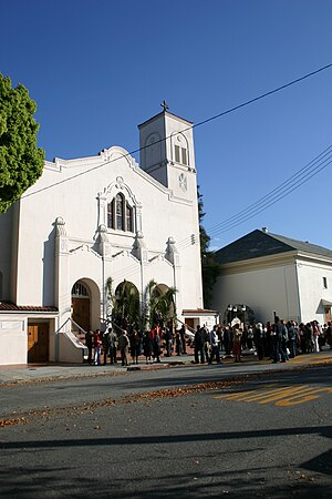
Mission Santa Clara de Asís
18th-century Spanish mission in California
Distance: Approx. 1174 meters
Latitude and longitude: 37.3493,-121.9415
Mission Santa Clara de Asís (Spanish: Misión Santa Clara de Asís) is a Spanish mission in the city of Santa Clara, California. The mission, which was the eighth in California, was founded on January 12, 1777, by the Franciscans. Named for Saint Clare of Assisi, who founded the order of the Poor Clares and was an early companion of St.
Saint Clare Parish
Distance: Approx. 1087 meters
Latitude and longitude: 37.34833333,-121.94305556
Saint Clare Parish is a parish in the Roman Catholic Diocese of San Jose in California. It is located in Santa Clara, California. The parish community of St.
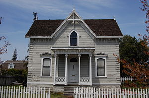
Andrew J. Landrum House
Historic house in California, United States
Distance: Approx. 1021 meters
Latitude and longitude: 37.34625,-121.945775
The Andrew J. Landrum House in Santa Clara, California, was built by Andrew J. Landrum, a prominent Santa Clara pioneer. Constructed in 1875, the house is an example of eclecticism in architectural styles. Landrum combined the then-popular Italianate and Carpenter Gothic styles he found in pattern books, as seen in the corner quoins, the Italianate porch with scroll brackets, gables with cross-bracing and the cruciform interior plan.

Charles Copeland Morse House
Historic house in California, United States
Distance: Approx. 763 meters
Latitude and longitude: 37.35206944,-121.94550556
The Charles Copeland Morse House was the home of Charles Copeland Morse, founder of the Ferry-Morse Seed Company. It is located in Santa Clara, California, and is a California Historical Landmark (#904), as well as listed on the National Register of Historic Places. This house is a classic Queen Anne Victorian.

Battle of Santa Clara (1847)
Battle that happened 2 1/2 miles from Santa Clara de Asis Mission
Distance: Approx. 106 meters
Latitude and longitude: 37.35333333,-121.95333333
The Battle of Santa Clara, nicknamed the "Battle of the Mustard Stalks", was a skirmish during the Mexican–American War, fought on January 2, 1847, 2+1⁄2 miles west of Mission Santa Clara de Asís in California. In late December, the former Californio military commander of Yerba Buena and a rancher from the San Mateo peninsula, Francisco Sanchez, imprisoned the American Mayor of Yerba Buena, Washington Bartlett, and five of his men, who were all engaged in a foraging raid on the peninsula. After receiving the news of the abduction on December 29, Commodore Montgomery in San Francisco ordered Marine Captain Ward Marston to rescue Bartlett and his men.

Triton Museum of Art
Art museum in Santa Clara, California
Distance: Approx. 403 meters
Latitude and longitude: 37.3561082,-121.9552176
The Triton Museum of Art is a contemporary art museum located at 1505 Warburton Avenue in Santa Clara, California.
Oratory of Our Mother of Perpetual Help
Church in California, USA
Distance: Approx. 815 meters
Latitude and longitude: 37.347554,-121.947429
The Oratory of Our Mother of Perpetual Help is a traditional Catholic chapel operating independently of the Diocese of San Jose.

Morgan Horse (sculpture)
Distance: Approx. 403 meters
Latitude and longitude: 37.3561082,-121.9552176
Morgan Horse, is a public artwork by artist Alexandrovich “Sascha” Stanislav Schnittmann, located in front of the Triton Museum of Art, in Santa Clara, California.

Santa Clara Women's Club Adobe
Historic site in Santa Clara County, California, United States
Distance: Approx. 1176 meters
Latitude and longitude: 37.35194444,-121.94083333
The Santa Clara Women's Club Adobe, also known as the Santa Clara Woman's Club, is a historic adobe structure in Santa Clara, California, dating back to 1880. Its construction can be attributed to the efforts of Franciscan padres from Mission Santa Clara de Asís. This adobe house, one of the oldest in the Santa Clara Valley, was part of a series of homes built between 1792 and 1800 to provide housing for Native American families associated with Mission Santa Clara.
Santa Clara Campaign Treaty Site
Template for California Historical Landmarks in Santa Clara County.
Distance: Approx. 60 meters
Latitude and longitude: 37.35222222,-121.95361111
The Santa Clara Campaign Treaty Site stands as a historic landmark that commemorates the Battle of Santa Clara, an armed clash that transpired during the Mexican-American War, fought on January 2, 1847. It was followed by a truce meeting the subsequent day. During this meeting, Marine Captain Ward Marston, commanding the United States expeditionary force, and Francisco Sánchez, the leader of the Mexican-Californian ranchers, came to an agreement on January 7, 1847.

Santa Clara Verein
Former social hall in California, United States
Distance: Approx. 1133 meters
Latitude and longitude: 37.35138889,-121.94138889
The Santa Clara Verein was a cultural and social center for the German community in Santa Clara, California, US. Built in 1868, it was listed on the National Register of Historic Places in 1985. The building was demolished in 1991 and is commemorated by a plaque.
Wilson High School (California)
Alternative high school in Santa Clara, Santa Clara County, California, United States
Distance: Approx. 738 meters
Latitude and longitude: 37.3463,-121.9567
Wilson High School is an alternative public high school in Santa Clara, California, United States. It is one of five high schools in the Santa Clara Unified School District (SCUSD) and is accredited by the Western Association of Schools and Colleges (WASC).
Weather in this IP's area
few clouds
24 Celsius
24 Celsius
20 Celsius
26 Celsius
1010 hPa
58 %
1010 hPa
1007 hPa
10000 meters
6.17 m/s
300 degree
20 %
06:53:39
19:09:14