Country:
 USA
USARegion:
City:
Latitude and Longitude:
Time Zone:
Postal Code:
IP information under different IP Channel
ip-api
Country
Region
City
ASN
Time Zone
ISP
Blacklist
Proxy
Latitude
Longitude
Postal
Route
IPinfo
Country
Region
City
ASN
Time Zone
ISP
Blacklist
Proxy
Latitude
Longitude
Postal
Route
MaxMind
Country
Region
City
ASN
Time Zone
ISP
Blacklist
Proxy
Latitude
Longitude
Postal
Route
Luminati
Country
USRegion
ca
City
redwoodcity
ASN
Time Zone
America/Los_Angeles
ISP
AS-SONICTELECOM
Latitude
Longitude
Postal
db-ip
Country
Region
City
ASN
Time Zone
ISP
Blacklist
Proxy
Latitude
Longitude
Postal
Route
ipdata
Country
Region
City
ASN
Time Zone
ISP
Blacklist
Proxy
Latitude
Longitude
Postal
Route
Popular places and events near this IP address

Woodside, California
Town in California, United States
Distance: Approx. 3233 meters
Latitude and longitude: 37.42083333,-122.25972222
Woodside is a small incorporated town in San Mateo County, California, United States, on the San Francisco Peninsula. It has a council–manager system of government. The population of the town was 5,309 at the 2020 census.

Skeggs Point (California)
Scenic turnout
Distance: Approx. 1736 meters
Latitude and longitude: 37.4109,-122.3056
Skeggs Point is a scenic turnout in San Mateo County along State Route 35 between Kings Mountain and State Route 84. The feature is marked with a guide sign along the road and is listed on the USGS 7.5 minute quadrangle, "Woodside, California" as well as in the National Geographic Names Database. The area is about three miles (five kilometers) west and 2,000 feet (600 m) above the town of Woodside.
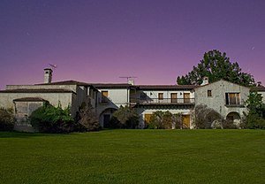
Jackling House
Mansion in California, US
Distance: Approx. 3438 meters
Latitude and longitude: 37.416502,-122.258434
The Jackling House was a mansion in Woodside, California, designed and built for copper mining magnate Daniel Cowan Jackling and his family by noted California architect George Washington Smith in 1925. Though it was considered a historic home, it was demolished in 2011 by its last owner, Steve Jobs. Its demolition followed a protracted court battle during which Jobs stated his intentions to build a smaller, contemporary-styled home on the site, though he died before any plans could be realized.
Kings Mountain, California
Unincorporated community in California, United States
Distance: Approx. 2456 meters
Latitude and longitude: 37.42055556,-122.32333333
Kings Mountain is an unincorporated community in San Mateo County, California, located along State Route 35 (Skyline Boulevard) between Skeggs Point and Pise Mountain. This is about 5 miles (8 km) north of Woodside Road (SR84). In the U.S. Geological Survey, National Geographic Names Database, the area is identified only as a geographic feature of type "summit" and not as a populated place.
Phleger Estate
Park in San Mateo County, California, U.S.
Distance: Approx. 3041 meters
Latitude and longitude: 37.45,-122.30833333
The Phleger Estate is a park in San Mateo County, California, United States. The park is located outside the town of Woodside and adjacent to Huddart County Park. The park was acquired in 1991 by the Peninsula Open Space Trust (POST) for $25 million and is now part of the Golden Gate National Recreation Area (GGNRA).
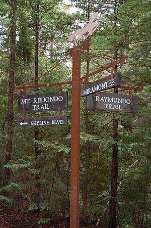
Rancho Cañada de Raymundo
Distance: Approx. 1761 meters
Latitude and longitude: 37.44,-122.3
Rancho Cañada de Raymundo was a 12,545-acre (50.77 km2) Mexican land grant in present-day San Mateo County, California given August 4, 1840 to Raimundo (also known as Raymundo), a native of Baja California, who was sent out by the padres of Mission Santa Clara to capture runaway Mission Indians in 1797. On the 1856 Rancho de las Pulgas and 1868 Easton maps, the valley of Laguna Creek was referred to as the Cañada de Raymundo. Laguna Creek was also alternatively known as Cañada Raimundo Creek.
West Union Creek
River in California, United States
Distance: Approx. 2569 meters
Latitude and longitude: 37.425,-122.26694444
West Union Creek is a 4.5-mile-long (7.2 km) stream originating on the east slope of Kings Mountain in the Santa Cruz Mountains, in San Mateo County, California, United States. It flows easterly down to the valley formed by the San Andreas Rift where it turns near the Phleger Estate to flow southeasterly on an unusually level course (for a mountain stream) to Adobe Corner in the town of Woodside where it joins Bear Gulch Creek, which in turn flows to San Francisquito Creek and ultimately, San Francisco Bay.
Runnymede Sculpture Farm
Distance: Approx. 2918 meters
Latitude and longitude: 37.444668,-122.274911
Runnymede Sculpture Farm is a private sculpture park in Woodside, California. It displays approximately 140 pieces of contemporary sculpture on 120 acres. The land was purchased in 1930 by Alma Spreckels Rosekrans for her horses and named after her father's prized stallion, Runnymede, sire of Kentucky Derby winner Morvich.

Woodside Store
United States historic place
Distance: Approx. 1785 meters
Latitude and longitude: 37.43042,-122.27723
The Woodside Store also called Tripp Store, sits at 3300 Tripp Road at Kings Mountain Road, Woodside, San Mateo County, California. This building has been listed on the National Register of Historic Places since 1985 and is listed as a California Historical Landmark in San Mateo County since 1949. It was preserved through the efforts of the San Mateo Historical Association in the 1940s.
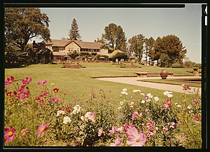
Mortimer Fleishhacker House
Historic house in California, United States
Distance: Approx. 2583 meters
Latitude and longitude: 37.432792,-122.268711
The Mortimer Fleishhacker House, also known as the Green Gables Estate, is a historic estate with an English manor house, built between 1911 and 1935, and located at 329 Albion Avenue in Woodside, California. The house has been listed on the National Register of Historic Places since September 26, 1986. The property has been used to host family weddings, corporate retreats, and historic summits including a United Nations 20th-anniversary gala in 1965.

The Mountain House
Restaurant in California, United States
Distance: Approx. 2803 meters
Latitude and longitude: 37.43822,-122.32259
The Mountain House is a restaurant located in King's Mountain, Woodside, California. Initially established over a century ago hosting a variety of community roles, it has been featured in a plethora of music video clips by prominent artists mostly due to its unique location inside a redwood forest.

El Corte de Madera Creek Open Space Preserve
Distance: Approx. 1807 meters
Latitude and longitude: 37.411883,-122.308851
El Corte de Madera Open Space Preserve is a 2,908-acre (1,177 ha) open space preserve in San Mateo County, California.
Weather in this IP's area
clear sky
19 Celsius
19 Celsius
14 Celsius
22 Celsius
1011 hPa
65 %
1011 hPa
958 hPa
10000 meters
6.17 m/s
350 degree
06:55:00
19:10:37