Country:
 USA
USARegion:
City:
Latitude and Longitude:
Time Zone:
Postal Code:
IP information under different IP Channel
ip-api
Country
Region
City
ASN
Time Zone
ISP
Blacklist
Proxy
Latitude
Longitude
Postal
Route
IPinfo
Country
Region
City
ASN
Time Zone
ISP
Blacklist
Proxy
Latitude
Longitude
Postal
Route
MaxMind
Country
Region
City
ASN
Time Zone
ISP
Blacklist
Proxy
Latitude
Longitude
Postal
Route
Luminati
Country
USRegion
ca
City
halfmoonbay
ASN
Time Zone
America/Los_Angeles
ISP
AS-SONICTELECOM
Latitude
Longitude
Postal
db-ip
Country
Region
City
ASN
Time Zone
ISP
Blacklist
Proxy
Latitude
Longitude
Postal
Route
ipdata
Country
Region
City
ASN
Time Zone
ISP
Blacklist
Proxy
Latitude
Longitude
Postal
Route
Popular places and events near this IP address

Half Moon Bay, California
City in California, United States
Distance: Approx. 2393 meters
Latitude and longitude: 37.45888889,-122.43694444
Half Moon Bay is a coastal city in San Mateo County, California, United States, approximately 25 miles (40 kilometers) south of San Francisco. Its population was 11,795 as of the 2020 census. Immediately north of Half Moon Bay is Pillar Point Harbor and the unincorporated community of Princeton-by-the-Sea.

Half Moon Bay State Beach
Group of beaches in San Mateo County, California
Distance: Approx. 435 meters
Latitude and longitude: 37.47388889,-122.44861111
Half Moon Bay State Beach is a 4-mile (6 km) stretch of protected beaches in the state park system of California, United States, on Half Moon Bay. From north to south it comprises Roosevelt, Dunes, Venice, and Francis Beaches. The 181-acre (73 ha) park was established in 1956.
Miramar, Half Moon Bay, California
Distance: Approx. 1815 meters
Latitude and longitude: 37.49305556,-122.45666667
Miramar (Spanish for "Sea View") is a district located within the city limits of Half Moon Bay in San Mateo County, California. Miramar Beach is located at Miramar. The east side of Highway 1 and north of the middle of Mirada road is in unincorporated San Mateo County.

Arroyo de en Medio
Distance: Approx. 1917 meters
Latitude and longitude: 37.492996,-122.459977
Arroyo de en Medio (Spanish for "in the middle creek") is a 2.5-mile-long (4.0 km) coastal stream in western San Mateo County, California. Arroyo de en Medio rises on the western slopes of Montara Mountain and discharges to the Pacific Ocean at Half Moon Bay at the location of the unincorporated community of Miramar at Miramar Beach. The watershed of Arroyo de en Medio consists of relatively permeable sandy soils capable of significant recharge to its aquifers, which supply considerable potable water to the local area.
Miramar Beach, California
Distance: Approx. 1956 meters
Latitude and longitude: 37.493274,-122.460254
Miramar Beach is a sandy beach in western San Mateo County, California. Miramar Beach is one of the numerous beaches on Half Moon Bay, a Pacific Ocean embayment noted for its surfing and extensive visitation. The marine terrace above the beach itself is situated approximately eight meters above mean sea level, and on this terrace is positioned the small unincorporated community of Miramar, which is a residential setting that also has several coastal visitor serving uses such as restaurant and lodging facilities.
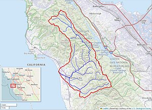
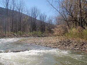
Pilarcitos Creek
River in California, United States
Distance: Approx. 257 meters
Latitude and longitude: 37.47527778,-122.44972222
Pilarcitos Creek (Spanish for: Little Pillars or Pillaries Creek) is a 13.5-mile-long (21.7 km) coastal stream in San Mateo County, California, United States, that rises on the western slopes of the Santa Cruz Mountains and descends through Pilarcitos Canyon to discharge into the Pacific Ocean Half Moon Bay State Beach. The Pilarcitos Creek watershed is a significant area of ecological, cultural and economic diversity. It is a source of clean drinking water for residents of the central coast and San Francisco Bay Area and supports several natural-resource based economies – including agriculture and recreational tourism.
Naples Creek
Stream in San Mateo County, California
Distance: Approx. 1404 meters
Latitude and longitude: 37.4893,-122.4561
Naples Creek is a stream in San Mateo County, California, United States that rises on the western slopes of the Santa Cruz Mountains and discharges to the Pacific Ocean. The specific point of discharge is onto Naples Beach, a unit of the Half Moon Bay State Beach. This watercourse runs through the city of Half Moon Bay, which municipality has planning jurisdiction over the creekside area within its city boundaries.

Half Moon Bay (California)
Body of water on the coast of northern California
Distance: Approx. 1999 meters
Latitude and longitude: 37.4832744,-122.4719216
Half Moon Bay is a bay of the Pacific Ocean on the coast of San Mateo County, California. The bay is approximately semi-circular, hence the name half moon, with sea access to the south. Coastal towns located there are Princeton-by-the-Sea, Miramar, El Granada, and the city of Half Moon Bay.

Frenchmans Creek (California)
River in California, United States
Distance: Approx. 335 meters
Latitude and longitude: 37.480496,-122.45081
Frenchmans Creek is a 4.4-mile-long (7.1 km) stream in San Mateo County, California. Locks Creek is its largest tributary.

Poplar Beach
Distance: Approx. 2525 meters
Latitude and longitude: 37.45525,-122.44497222
Poplar Beach is a beach located in and operated by the city of Half Moon Bay, California. It lies at the end of Poplar Street west of State Route 1. Located roughly a half mile south of Half Moon Bay State Beach, Poplar Beach allows horses and leashed dogs.
Half Moon Bay High School
Public school in Half Moon Bay, San Mateo County, California, United States
Distance: Approx. 2037 meters
Latitude and longitude: 37.4735,-122.428
Half Moon Bay High School is an American public high school located in Half Moon Bay, in San Mateo County, California. It is part of the Cabrillo Unified School District.

Bach Dancing & Dynamite Society
Music venue in Half Moon Bay, California
Distance: Approx. 2131 meters
Latitude and longitude: 37.4946,-122.46134
The Bach Dancing & Dynamite Society is an oceanfront non-profit music venue located at the Douglas Beach House in Half Moon Bay, California. The venue was founded in 1964 by Pete Douglas and is now run by his daughter, Barbara Douglas Riching. Pete Douglas moved to Half Moon Bay in 1957.
Weather in this IP's area
scattered clouds
19 Celsius
19 Celsius
16 Celsius
24 Celsius
1012 hPa
76 %
1012 hPa
1011 hPa
10000 meters
7.72 m/s
10 degree
40 %
06:55:36
19:11:14