Country:
 USA
USARegion:
City:
Latitude and Longitude:
Time Zone:
Postal Code:
IP information under different IP Channel
ip-api
Country
Region
City
ASN
Time Zone
ISP
Blacklist
Proxy
Latitude
Longitude
Postal
Route
IPinfo
Country
Region
City
ASN
Time Zone
ISP
Blacklist
Proxy
Latitude
Longitude
Postal
Route
MaxMind
Country
Region
City
ASN
Time Zone
ISP
Blacklist
Proxy
Latitude
Longitude
Postal
Route
Luminati
Country
USRegion
ca
City
vallejo
ASN
Time Zone
America/Los_Angeles
ISP
AS-SONICTELECOM
Latitude
Longitude
Postal
db-ip
Country
Region
City
ASN
Time Zone
ISP
Blacklist
Proxy
Latitude
Longitude
Postal
Route
ipdata
Country
Region
City
ASN
Time Zone
ISP
Blacklist
Proxy
Latitude
Longitude
Postal
Route
Popular places and events near this IP address

Vallejo, California
City in California, United States
Distance: Approx. 1219 meters
Latitude and longitude: 38.11305556,-122.23583333
Vallejo ( və-LAY-(h)oh; Spanish: [baˈʎexo]) is a city in Solano County, California and the second largest city in the North Bay region of the Bay Area. Located on the shores of San Pablo Bay, the city had a population of 126,090 at the 2020 census. Vallejo is home to the California Maritime Academy, Touro University California and Six Flags Discovery Kingdom.

Mare Island Naval Shipyard
United States historic place
Distance: Approx. 2312 meters
Latitude and longitude: 38.09,-122.26333333
The Mare Island Naval Shipyard (MINSY or MINS) was the first United States Navy base established on the Pacific Ocean and was in service 142 years from 1854 to 1996. It is located on Mare Island, 23 miles (37 km) northeast of San Francisco, in Vallejo, California. MINSY made a name for itself as the premier U.S. West Coast submarine port as well as serving as the controlling force in San Francisco Bay Area shipbuilding efforts during World War II. The naval base was closed on 31 March 1996, with more than 7,500 civilians on its payroll, and has gone through several redevelopment phases.

USS DeLong (DD-129)
Wickes-class destroyer
Distance: Approx. 2082 meters
Latitude and longitude: 38.0888,-122.2575
USS DeLong (DD-129) was a Wickes-class destroyer built for the United States Navy during World War I.

Vallejo Station
Transit station in California, U.S.
Distance: Approx. 1702 meters
Latitude and longitude: 38.100534,-122.26303
Vallejo Station is an intermodal transit station in Vallejo, California. It was created by combining the Vallejo Ferry Terminal, the Vallejo Transit Center bus station, and a connecting multi-story parking garage and paseo. It is located in the western part of Central Vallejo.

USS Crescent City
Distance: Approx. 2198 meters
Latitude and longitude: 38.101113,-122.268966
USS Crescent City (AP-40/APA-21) was the lead ship of the Crescent City-class attack transports that served with the US Navy during World War II. The ship was built as the cargo and passenger liner Delorleans for the Mississippi Shipping Company's Delta Line. After brief commercial operation the ship was among 28 vessels requisitioned in June 1941 for the Navy and the Army. The Navy renamed the ship Crescent City, a popular nickname for New Orleans, Louisiana, upon commissioning 10 October 1941.

Empress Theatre (California)
Distance: Approx. 1202 meters
Latitude and longitude: 38.10223,-122.25767
The Empress Theatre is a historical landmark located in downtown Vallejo, California built in 1911. It was re-opened in 2008 after nearly 20 years of disuse following the 1989 Loma Prieta earthquake. The one room movie house has undergone complete renovation and seismic retrofit.
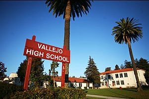
Vallejo High School
School in Vallejo, California, United States
Distance: Approx. 1099 meters
Latitude and longitude: 38.11416667,-122.24444444
Vallejo High School is a high school located in Vallejo, California. It is part of the Vallejo City Unified School District and has been in the heart of Vallejo for more than 100 years. It currently serves the west side of the city (west of Interstate 80).

First Presbyterian Church (Vallejo, California)
Church in California, USA
Distance: Approx. 2354 meters
Latitude and longitude: 38.11361111,-122.26833333
The First Presbyterian Church in Vallejo is a historic church in Vallejo, California. Founded in 1862 as an Old School congregation during the Old School–New School Controversy, it is now part of the Presbyterian Church (USA)'s Presbytery of the Redwoods. In 1954, the congregation consecrated the current building, which houses classrooms, offices, an auditorium, a social hall, a chapel, and a sanctuary.

Shooting of Sean Monterrosa
2020 police shooting of a Latino American man in Vallejo, California
Distance: Approx. 2139 meters
Latitude and longitude: 38.123,-122.2498
Sean Monterrosa was a 22-year-old Latino American man who was fatally shot on June 2, 2020, by Vallejo police officer Jarrett Tonn. Monterrosa was on his knees and had his hands above his waist when Tonn shot him through the windshield of his unmarked police pickup truck. The police later said Tonn shot him because he erroneously believed a hammer in Monterrosa's pocket was a gun.

Vallejo City Hall
United States historic place
Distance: Approx. 1120 meters
Latitude and longitude: 38.1026,-122.2568
Two former city hall buildings in Vallejo, California are listed in the National Register of Historic Places. Today the old city hall built in 1872 partially houses the Temple Art Lofts, a combination art gallery and apartment complex, and the 1927 city hall houses the Vallejo Naval and Historical Museum.

California State Capitol (Vallejo, California)
Historical place in Solano County, United States
Distance: Approx. 1388 meters
Latitude and longitude: 38.10007,-122.2591
Vallejo California State Capitol was founded on May 4, 1852, at a building in Vallejo, California in Solano County, California. The Vallejo California State Capitol site is a California Historical Landmark No. 574 listed on April 1, 1957.

St. Peter's Chapel, Mare Island
United States historic place
Distance: Approx. 2534 meters
Latitude and longitude: 38.09444444,-122.27027778
St. Peter's Chapel, Mare Island (locally, St. Peter's Chapel) is an historic church building located on Walnut near Cedar Avenues, Vallejo, Solano County, California, in the historic core of the Mare Island Naval Shipyard.
Weather in this IP's area
clear sky
24 Celsius
24 Celsius
18 Celsius
28 Celsius
1011 hPa
58 %
1011 hPa
1010 hPa
10000 meters
6.17 m/s
200 degree
06:54:40
19:10:32