173.197.207.37 - IP Lookup: Free IP Address Lookup, Postal Code Lookup, IP Location Lookup, IP ASN, Public IP
Country:
Region:
City:
Location:
Time Zone:
Postal Code:
IP information under different IP Channel
ip-api
Country
Region
City
ASN
Time Zone
ISP
Blacklist
Proxy
Latitude
Longitude
Postal
Route
Luminati
Country
Region
fl
City
sarasota
ASN
Time Zone
America/New_York
ISP
TWC-7843-BB
Latitude
Longitude
Postal
IPinfo
Country
Region
City
ASN
Time Zone
ISP
Blacklist
Proxy
Latitude
Longitude
Postal
Route
IP2Location
173.197.207.37Country
Region
virginia
City
harrisonburg
Time Zone
America/New_York
ISP
Language
User-Agent
Latitude
Longitude
Postal
db-ip
Country
Region
City
ASN
Time Zone
ISP
Blacklist
Proxy
Latitude
Longitude
Postal
Route
ipdata
Country
Region
City
ASN
Time Zone
ISP
Blacklist
Proxy
Latitude
Longitude
Postal
Route
Popular places and events near this IP address

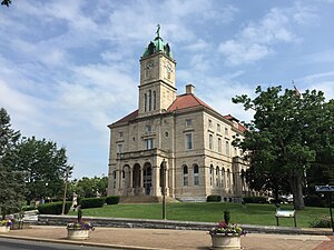
Rockingham County, Virginia
County in Virginia, United States
Distance: Approx. 5536 meters
Latitude and longitude: 38.52,-78.88
Rockingham County is a county located in the U.S. state of Virginia. As of the 2020 census, the population was 83,757. Its county seat is the independent city of Harrisonburg.

George Washington and Jefferson National Forests
Pair of National Forests in the United States
Distance: Approx. 5179 meters
Latitude and longitude: 38.5,-79
The George Washington and Jefferson National Forests is an administrative entity combining two U.S. National Forests into one of the largest areas of public land in the Eastern United States. The forests cover 1.8 million acres (2,800 sq mi) of land in the Appalachian Mountains of Virginia, West Virginia, and Kentucky. Approximately 1 million acres (1,600 sq mi) of the forest are remote and undeveloped and 139,461 acres (218 sq mi) have been designated as wilderness areas, which prohibits future development.

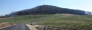
Mole Hill (Virginia)
Hill and Extinct volcano in Harrisonburg, Virginia
Distance: Approx. 6510 meters
Latitude and longitude: 38.44861111,-78.95333333
Mole Hill is a rounded hill composed of basalt, a volcanic rock, formed during the Eocene epoch of the Paleogene period. It is the eroded remnant of what was an active volcano approximately 47 million years ago, making it one of the youngest volcanoes on the east coast of North America. It is located west of Harrisonburg, Virginia, in Rockingham County.

Singers Glen, Virginia
Census-designated place in Virginia, United States
Distance: Approx. 5401 meters
Latitude and longitude: 38.55,-78.91416667
Singers Glen is an Census-designated place (CDP) located in Rockingham County, Virginia, and situated between Little North Mountain and Interstate 81. Singers Glen is a historic settlement that is registered by both the Virginia Historic Landmarks Commission and the United States Department of the Interior. The community comprises one road (Singers Glen Road), the Singers Glen Post Office, a recycling center, the Singers Glen School, the Singers Glen Volunteer Fire Company, Singers Glen volunteer rescue squad, one store, and a Methodist and Baptist Church.
Dale Enterprise, Virginia
Unincorporated community in Virginia, United States
Distance: Approx. 5714 meters
Latitude and longitude: 38.455,-78.93888889
Dale Enterprise is an unincorporated community in Rockingham County, Virginia, United States. The name dates to 1872, when it was time to name the village's post office. The place was previously known as Millersville, after the Miller family who ran an early store there.
Hinton, Virginia
Unincorporated community in Virginia, United States
Distance: Approx. 5271 meters
Latitude and longitude: 38.46583333,-78.9725
Hinton is an unincorporated community located in Rockingham County, in the U.S. state of Virginia. It is located northwest of Harrisonburg along U.S. Route 33 and Route 752 near the edge of George Washington National Forest.
Center for Justice and Peacebuilding
Distance: Approx. 6653 meters
Latitude and longitude: 38.470966,-78.879519
Center for Justice and Peacebuilding (CJP) is an accredited graduate-level program founded in 1994. It also offers non-credit training. The program specializes in conflict transformation, restorative justice, trauma healing, equitable development, and addressing organizational conflict.

New Erection, Virginia
Unincorporated community in Virginia, United States
Distance: Approx. 3827 meters
Latitude and longitude: 38.47361111,-78.9275
New Erection is an unincorporated community located in Rockingham County, in the U.S. state of Virginia. The community took its name from a Presbyterian church called "New Erection" because it was re-erected there, having previously been erected in Dayton.

Signal Hill (Culpeper, Virginia)
Historic house in Virginia, United States
Distance: Approx. 6522 meters
Latitude and longitude: 38.44861111,-78.95416667
Signal Hill is a historic home and farm complex located at Culpeper, Culpeper County, Virginia. The farmhouse was built about 1900, and is a two-story, asymmetrically cruciform brick house, in a refined, late-Victorian style. It features a one-story, 13-bay, wraparound porch with a hipped roof.

Joseph Funk House
Historic house in Virginia, United States
Distance: Approx. 5357 meters
Latitude and longitude: 38.55083333,-78.91777778
Joseph Funk House is a historic home located at Singers Glen, Rockingham County, Virginia. It was built about 1810, and is a 1+1⁄2-story, log dwelling with a gable roof and an undercut front gallery. The house is sheathed with weatherboarding.

Singers Glen Historic District
Historic district in Virginia, United States
Distance: Approx. 4075 meters
Latitude and longitude: 38.53777778,-78.91722222
Singers Glen Historic District is a national historic district located at Singers Glen, Rockingham County, Virginia. The district encompasses 65 contributing buildings and 2 contributing sites in the village of Singers Glen. The district retains much of its late 19th-century air and most of its original buildings.

Breneman-Turner Mill
United States historic place
Distance: Approx. 6110 meters
Latitude and longitude: 38.52527778,-78.87527778
Breneman-Turner Mill is a historic grist mill located near Harrisonburg, Rockingham County, Virginia. It was built about 1800, and is a 2 1/2-story, Federal style brick building. The building retains its water wheel, measuring 16 feet in diameter and 5 feet wide, and three sets of burr stones.
Weather in this IP's area
clear sky
7 Celsius
5 Celsius
5 Celsius
8 Celsius
1008 hPa
68 %
1008 hPa
955 hPa
10000 meters
2.06 m/s
210 degree