173.197.205.237 - IP Lookup: Free IP Address Lookup, Postal Code Lookup, IP Location Lookup, IP ASN, Public IP
Country:
Region:
City:
Location:
Time Zone:
Postal Code:
IP information under different IP Channel
ip-api
Country
Region
City
ASN
Time Zone
ISP
Blacklist
Proxy
Latitude
Longitude
Postal
Route
Luminati
Country
Region
fl
City
sarasota
ASN
Time Zone
America/New_York
ISP
TWC-7843-BB
Latitude
Longitude
Postal
IPinfo
Country
Region
City
ASN
Time Zone
ISP
Blacklist
Proxy
Latitude
Longitude
Postal
Route
IP2Location
173.197.205.237Country
Region
virginia
City
elkwood
Time Zone
America/New_York
ISP
Language
User-Agent
Latitude
Longitude
Postal
db-ip
Country
Region
City
ASN
Time Zone
ISP
Blacklist
Proxy
Latitude
Longitude
Postal
Route
ipdata
Country
Region
City
ASN
Time Zone
ISP
Blacklist
Proxy
Latitude
Longitude
Postal
Route
Popular places and events near this IP address

Sumerduck, Virginia
Unincorporated community in Virginia, United States
Distance: Approx. 6874 meters
Latitude and longitude: 38.46,-77.72805556
Sumerduck ( SUM-ər-duk) is a small unincorporated village located equidistant between Fredericksburg, Culpeper, and Warrenton, as it is in Fauquier County in the U.S. state of Virginia. The name was derived from the fact that ducks flocked here in the summer. Sumerduck is home to the major portion of the C.F. Phelps Wildlife Management Area, with several entrances to the reserve off of the major thoroughfare, VA Route 651.
Second Battle of Rappahannock Station
Battle of the American Civil War
Distance: Approx. 8269 meters
Latitude and longitude: 38.533,-77.8136
The Second Battle of Rappahannock Station took place on November 7, 1863, near the village of Rappahannock Station (now Remington, Virginia), on the Orange and Alexandria Railroad. It was between Confederate forces under Maj. Gen.

First Battle of Rappahannock Station
Battle of the American Civil War
Distance: Approx. 7869 meters
Latitude and longitude: 38.5272,-77.8302
The First Battle of Rappahannock Station, (also known as Waterloo Bridge, White Sulphur Springs, Lee Springs, and Freeman's Ford) as took place on August 23, 1862, at present-day Remington, Virginia, as part of the Northern Virginia Campaign of the American Civil War.

Battle of Kelly's Ford
Battle of the American Civil War
Distance: Approx. 3094 meters
Latitude and longitude: 38.476921,-77.77988
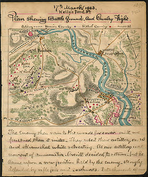
The Battle of Kelly's Ford, also known as the Battle of Kellysville or Kelleysville, took place on March 17, 1863, in Culpeper County, Virginia, as part of the cavalry operations along the Rappahannock River during the American Civil War. It set the stage for Brandy Station and other cavalry actions of the Gettysburg Campaign that summer. Twenty-one hundred troopers of Brig.
Stevensburg, Virginia
Unincorporated community in Virginia, United States
Distance: Approx. 8324 meters
Latitude and longitude: 38.44138889,-77.89972222
Stevensburg is a small rural unincorporated community located at the intersection of Route 3 and Route 663 in Culpeper County, Virginia, United States. Stevensburg is about 6.9 miles east of Culpeper. Stevensburg's ZIP code is 22741.

Madden's Tavern
Historic commercial building in Virginia, United States
Distance: Approx. 3189 meters
Latitude and longitude: 38.4325,-77.82111111
A rare occurrence in antebellum Virginia, Madden's Tavern once functioned as a prime example of black entrepreneurship. The building was completed in 1840, and was run by a free black man named Willis Madden. Before running his own business, Madden worked a variety of trades, including a blacksmith, distiller, cobbler, teamster, farm laborer, and nail maker.

Kelly's Ford, Virginia
Distance: Approx. 3108 meters
Latitude and longitude: 38.47722222,-77.78
Kelly's Ford was a major crossing point on the Rappahannock River. It was the site of a Civil War battle in 1863 and later Stoneman's raid for control of the river ford. Today it is the only crossing on the river between Fredericksburg and Remington.

Chester F. Phelps Wildlife Management Area
Protected area of Virginia, United States
Distance: Approx. 5139 meters
Latitude and longitude: 38.4532,-77.7484
Chester F. Phelps Wildlife Management Area (also known as the C.F. Phelps Wildlife Management Area) is a 4,539-acre (18.37 km2) Wildlife Management Area located in Fauquier and Culpeper counties, Virginia. It contains over 1,000 acres (4 km2) of open land previously used for agriculture; additional open areas may be found within the forests on the property. Most of the terrain is rolling, low, and shallow; the steepest land can be seen near the Rappahannock River, which forms a large part of the property's western border.
Lagrange, Virginia
Unincorporated community in Virginia, United States
Distance: Approx. 4471 meters
Latitude and longitude: 38.44138889,-77.85305556
Lagrange is an unincorporated community in Culpeper County, Virginia, United States.
Elkwood, Virginia
Unincorporated community in Virginia, United States
Distance: Approx. 7258 meters
Latitude and longitude: 38.51166667,-77.85583333
Elkwood is an town in Culpeper County, Virginia, United States. Elkwood is located on U.S. Route 15 8.1 miles (13.0 km) east-northeast of Culpeper. Elkwood has a post office with ZIP code 22718.

Lignum, Virginia
Unincorporated community in Virginia, United States
Distance: Approx. 5095 meters
Latitude and longitude: 38.41583333,-77.82666667
Lignum is an unincorporated community in Culpeper County, Virginia, United States. Lignum is located on Virginia State Route 3 10 miles (16 km) east-southeast of Culpeper. Lignum has a post office with ZIP code 22726, which opened on November 14, 1877.

Salubria
Historic house in Virginia, United States
Distance: Approx. 7177 meters
Latitude and longitude: 38.43916667,-77.88527778
Salubria is a historic plantation house located at Stevensburg, Culpeper County, Virginia. It was built in 1757, and is a two-story, hipped roof dwelling with two large corbel-capped chimneys on the interior ends. Salubria was the birthplace of Admiral Cary Travers Grayson, personal physician to President Woodrow Wilson.
Weather in this IP's area
overcast clouds
2 Celsius
-2 Celsius
0 Celsius
3 Celsius
1018 hPa
76 %
1018 hPa
1006 hPa
10000 meters
3.09 m/s
300 degree
100 %
