173.197.204.211 - IP Lookup: Free IP Address Lookup, Postal Code Lookup, IP Location Lookup, IP ASN, Public IP
Country:
Region:
City:
Location:
Time Zone:
Postal Code:
IP information under different IP Channel
ip-api
Country
Region
City
ASN
Time Zone
ISP
Blacklist
Proxy
Latitude
Longitude
Postal
Route
Luminati
Country
Region
fl
City
sarasota
ASN
Time Zone
America/New_York
ISP
TWC-7843-BB
Latitude
Longitude
Postal
IPinfo
Country
Region
City
ASN
Time Zone
ISP
Blacklist
Proxy
Latitude
Longitude
Postal
Route
IP2Location
173.197.204.211Country
Region
california
City
tulare
Time Zone
America/Los_Angeles
ISP
Language
User-Agent
Latitude
Longitude
Postal
db-ip
Country
Region
City
ASN
Time Zone
ISP
Blacklist
Proxy
Latitude
Longitude
Postal
Route
ipdata
Country
Region
City
ASN
Time Zone
ISP
Blacklist
Proxy
Latitude
Longitude
Postal
Route
Popular places and events near this IP address

Tulare, California
City in California, United States
Distance: Approx. 258 meters
Latitude and longitude: 36.20666667,-119.3425
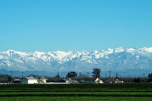
Tulare ( tuu-LAIR-ee) is a city in Tulare County, California, United States. The population was 68,875 per the 2020 census. It is located in the heart of the San Joaquin Valley, 8 mi (13 km) south of Visalia and 60 mi (97 km) north of Bakersfield.

World Ag Expo
Annual farm show in California, U.S.
Distance: Approx. 4863 meters
Latitude and longitude: 36.1662,-119.3266
World Ag Expo is the largest annual outdoor agricultural exposition with over 1,200 exhibitors and an attendance of more than 100,000 each year. It is held at the International Agri-Center in Tulare, California, in the United States, starting on the second Tuesday of February. It has officially been designated by the U.S. Department of Commerce as an affiliate of the Foreign Buyer Program, which encourages export of American-made goods.

Mefford Field Airport
Airport in Tulare County, California
Distance: Approx. 5893 meters
Latitude and longitude: 36.15666667,-119.32666667
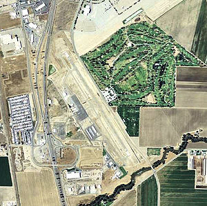
Mefford Field (IATA: TLR, ICAO: KTLR, FAA LID: TLR) is a public use airport in Tulare County, California, United States. It is owned by the City of Tulare and located three nautical miles (6 km) southeast of its central business district. This airport is included in the National Plan of Integrated Airport Systems for 2011–2015, which categorized it as a general aviation facility.

Tulare Union High School
School in Tulare, California, United States
Distance: Approx. 235 meters
Latitude and longitude: 36.20888889,-119.33805556
Tulare Union High School ( ) is a public school for secondary education in Tulare, Tulare County, California, United States. This high school is part of the Tulare Joint Union High School District, along with Tulare Western High School and Mission Oak High School, led by Superintendent Tony Rodriguez. Enrollment at the four-year high school is approximately 1,650 for the current school year.
Tulare Western High School
School in Tulare, California , United States
Distance: Approx. 1784 meters
Latitude and longitude: 36.2151,-119.35864
Tulare Western High School ( ) is a public high school in Tulare, California, United States. Tulare Western's current enrollment is close to 2,100, making it the largest of the three Tulare high schools. The school is part of the Tulare Joint Union High School District, along with Tulare Union High School and Mission Oak High School, headquartered in Tulare, with Lucy Van Scyoc as District Superintendent.
KBLO
Radio station in Corcoran, California
Distance: Approx. 5988 meters
Latitude and longitude: 36.18444444,-119.40027778
KBLO (102.3 FM) is a radio station broadcasting a Christian Spanish format. Licensed to Corcoran, California, United States, the station serves the Visalia-Tulare-Hanford area. The station is currently owned by Centro Cristiano Amistad Church.
Tagus Ranch
Distance: Approx. 7634 meters
Latitude and longitude: 36.27388889,-119.36583333
Tagus Ranch is an abandoned restaurant, hotel, and 7,000 acre orchard, Founded by Hulett C. Merritt in 1912, and left in the mid 80's. Tagus Ranch was a popular venue, where many country musicians performed. Tagus Ranch is located less than 3 miles north of Tulare, California, off of Highway 99.
Mission Oak High School
School in Tulare, California , United States
Distance: Approx. 4005 meters
Latitude and longitude: 36.19694444,-119.29833333
Mission Oak High School is a public high school in Tulare, California. Along with Tulare Union High School and Tulare Western High School, it is part of the Tulare Joint Union High School District.
Farm Credit Dairy Center
Arena in California, United States
Distance: Approx. 4823 meters
Latitude and longitude: 36.16836,-119.32009
Farm Credit Dairy Center is an 8,000-seat indoor multipurpose arena located in Tulare, California. It is part of the Heritage Complex, which is the site of the World Ag Expo. The arena contains no permanent seats; however portable stands can be brought in for sporting events, concerts, boxing, professional wrestling and graduation ceremonies.

East Tulare Villa, California
Census-designated place in California, United States
Distance: Approx. 5271 meters
Latitude and longitude: 36.20361111,-119.28222222
East Tulare Villa is a census-designated place (CDP) in Tulare County, California. East Tulare Villa sits at an elevation of 302 feet (92 m). The 2010 United States census reported East Tulare Villa's population was 778.

Matheny, California
Census-designated place in California, United States
Distance: Approx. 4329 meters
Latitude and longitude: 36.17055556,-119.35166667
Matheny is a census-designated place (CDP) in Tulare County, California. Matheny sits at an elevation of 269 feet (82 m). The 2010 United States census reported Matheny's population was 1,212.
Tulare Historical Museum
Local museum in Tulare, California
Distance: Approx. 1236 meters
Latitude and longitude: 36.20724,-119.35429
The Tulare Historical Museum is a local history museum, in Tulare, California, which is owned and operated by the Tulare City Historical Society. It is located at 444 West Tulare Avenue.
Weather in this IP's area
fog
7 Celsius
5 Celsius
7 Celsius
8 Celsius
1020 hPa
100 %
1020 hPa
1009 hPa
402 meters
2.57 m/s
240 degree
100 %