173.197.203.199 - IP Lookup: Free IP Address Lookup, Postal Code Lookup, IP Location Lookup, IP ASN, Public IP
Country:
Region:
City:
Location:
Time Zone:
Postal Code:
IP information under different IP Channel
ip-api
Country
Region
City
ASN
Time Zone
ISP
Blacklist
Proxy
Latitude
Longitude
Postal
Route
Luminati
Country
Region
fl
City
sarasota
ASN
Time Zone
America/New_York
ISP
TWC-7843-BB
Latitude
Longitude
Postal
IPinfo
Country
Region
City
ASN
Time Zone
ISP
Blacklist
Proxy
Latitude
Longitude
Postal
Route
IP2Location
173.197.203.199Country
Region
florida
City
plantation
Time Zone
America/New_York
ISP
Language
User-Agent
Latitude
Longitude
Postal
db-ip
Country
Region
City
ASN
Time Zone
ISP
Blacklist
Proxy
Latitude
Longitude
Postal
Route
ipdata
Country
Region
City
ASN
Time Zone
ISP
Blacklist
Proxy
Latitude
Longitude
Postal
Route
Popular places and events near this IP address

Plantation, Sarasota County, Florida
Census-designated place in Florida, United States
Distance: Approx. 574 meters
Latitude and longitude: 27.063568,-82.370146
Plantation is a census-designated place (CDP) in Sarasota County, Florida, United States. The population was 5,034 at the 2020 census, up from 4,919 at the 2010 census. It is part of the North Port–Bradenton–Sarasota, Florida Metropolitan Statistical Area.

South Venice, Florida
Census-designated place in Florida, United States
Distance: Approx. 4854 meters
Latitude and longitude: 27.04583333,-82.415
South Venice is a census-designated place (CDP) in Sarasota County, Florida, United States. The population was 15,619 at the 2020 census, up from 13,949 at the 2010 census. It is part of the North Port–Bradenton–Sarasota, Florida Metropolitan Statistical Area.

Venice Gardens, Florida
Census-designated place in Florida, United States
Distance: Approx. 3468 meters
Latitude and longitude: 27.07055556,-82.40777778
Venice Gardens is a census-designated place (CDP) in Sarasota County, Florida, United States. The population was 3,402 at the 2020 census, down from 7,104 at the 2010 census. It is part of the North Port–Bradenton–Sarasota, Florida Metropolitan Statistical Area.

Edgewood Historic District (Venice, Florida)
Historic district in Florida, United States
Distance: Approx. 6534 meters
Latitude and longitude: 27.09611111,-82.43083333
The Edgewood Historic District is a U.S. historic district (designated as such on December 18, 1989) located in Venice, Florida. The district is bounded by School Street, Myrtle Avenue, Venice-By-Way, and Groveland Avenue. It contains 36 historic buildings.
WTZB
Radio station in Englewood, Florida
Distance: Approx. 5001 meters
Latitude and longitude: 27.106,-82.4
WTZB (105.9 FM "Z105") is a commercial radio station licensed to Englewood, Florida, and serving the Sarasota - Bradenton area of Central Florida. It airs a hard-edged mainstream rock format and is owned by iHeartMedia, Inc. The studios and offices are on Fruitville Road (Florida State Road 780) in Sarasota.
Manasota, Florida
Unincorporated community in Florida, United States
Distance: Approx. 6572 meters
Latitude and longitude: 27.01527778,-82.4025
Manasota is an unincorporated community in Sarasota County, Florida, United States, located on the mainland south of Venice. The Manasota Bridge (County Road 774) crosses Lemon Bay (Gulf Intracoastal Waterway), connecting Manasota to Manasota Beach and Manasota Key. It is home to a United States Postal Service processing and distribution center for Manatee and Sarasota counties.

Venice Army Air Field
Distance: Approx. 6691 meters
Latitude and longitude: 27.07166667,-82.44027778
Venice Army Airfield is an inactive United States Army Forces base, approximately 2 miles (3.2 km) south-southeast of Venice, Florida. It was active during World War II as a Third Air Force training airfield. It was closed on November 30, 1945.
Jelks Preserve
Nature preserve in Florida, United States
Distance: Approx. 4343 meters
Latitude and longitude: 27.0915,-82.33784
Jelks Preserve is a 614-acre (248 ha) natural preserve with 8 miles (13 km) of trail along the Myakka River in southern Sarasota County, Florida.
Manasota Scrub Preserve
Preserve in Sarasota County, Florida USA
Distance: Approx. 5957 meters
Latitude and longitude: 27.018,-82.394
The Manasota Scrub Preserve is an area of protected land in Sarasota County, Florida. It is located at 2695 Bridge Street in Englewood, Florida, in a suburban area that is part of the Lemon Bay watershed. The 154-acre preserve was acquired during 2000 and 2002 with funds from the state's Environmentally Sensitive Lands Protection Program and the Florida Communities Trust.

CoolToday Park
Ballpark in North Port, Florida, US
Distance: Approx. 6501 meters
Latitude and longitude: 27.033728,-82.319887
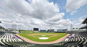
CoolToday Park is a ballpark in North Port, Florida, located in the southern portion of Sarasota County, 35 miles (56 km) south of Sarasota, Florida. It is the spring training home of the Atlanta Braves of Major League Baseball. The ballpark opened on March 24, 2019, with the Braves' 4–2 win over the Tampa Bay Rays.
Wellen Park, Florida
Planned community in Florida, United States
Distance: Approx. 5527 meters
Latitude and longitude: 27.04972222,-82.32111111
Wellen Park (formerly known as the West Villages) is a planned community located in Sarasota County, Florida, United States. The majority of Wellen Park is located along US 41 and River Road within the city limits of North Port, with some portions of the community extending into unincorporated Sarasota County.
Woodmere, Florida
Unincorporated community in Florida, United States
Distance: Approx. 5575 meters
Latitude and longitude: 27.02055556,-82.39055556
Woodmere is an unincorporated community 5 miles (8.0 km) north of Englewood in Sarasota County, Florida.
Weather in this IP's area
scattered clouds
11 Celsius
10 Celsius
11 Celsius
12 Celsius
1019 hPa
62 %
1019 hPa
1018 hPa
10000 meters
5.01 m/s
8.42 m/s
358 degree
33 %