173.197.202.2 - IP Lookup: Free IP Address Lookup, Postal Code Lookup, IP Location Lookup, IP ASN, Public IP
Country:
Region:
City:
Location:
Time Zone:
Postal Code:
IP information under different IP Channel
ip-api
Country
Region
City
ASN
Time Zone
ISP
Blacklist
Proxy
Latitude
Longitude
Postal
Route
Luminati
Country
IPinfo
Country
Region
City
ASN
Time Zone
ISP
Blacklist
Proxy
Latitude
Longitude
Postal
Route
IP2Location
173.197.202.2Country
Region
california
City
modesto
Time Zone
America/Los_Angeles
ISP
Language
User-Agent
Latitude
Longitude
Postal
db-ip
Country
Region
City
ASN
Time Zone
ISP
Blacklist
Proxy
Latitude
Longitude
Postal
Route
ipdata
Country
Region
City
ASN
Time Zone
ISP
Blacklist
Proxy
Latitude
Longitude
Postal
Route
Popular places and events near this IP address

Empire, California
Census-designated place in California, United States
Distance: Approx. 1427 meters
Latitude and longitude: 37.64416667,-120.9075
Empire is a census-designated place (CDP) in Stanislaus County, California, United States. The population was 4,189 at the 2010 census, up from 3,903 at the 2000 census. It is part of the Modesto Metropolitan Statistical Area.

Modesto City–County Airport
Airport in Modesto, California
Distance: Approx. 5071 meters
Latitude and longitude: 37.62583333,-120.95444444
Modesto City–County Airport (IATA: MOD, ICAO: KMOD, FAA LID: MOD) (Harry Sham Field) is two miles (3 km) southeast of Modesto in Stanislaus County, California, United States.

KESP
Radio station in Modesto, California
Distance: Approx. 5197 meters
Latitude and longitude: 37.68972222,-120.95333333
KESP (970 AM) is a sports radio station in Modesto, California, United States. The station serves Modesto, Stockton, Lodi, and surrounding communities of the northern San Joaquin Valley. It is currently owned by Cumulus Media.
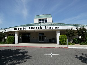
Modesto station
Distance: Approx. 1420 meters
Latitude and longitude: 37.6690288,-120.9149256
Modesto station is a staffed Amtrak station in Modesto, California. It is served by the San Joaquins service. Designed by Pacific Design Associates of Modesto and VBN Architects of Oakland, the $2.4 million depot was built on four acres of former dairy pastureland.
Tuolumne River Regional Park
Park in San Joaquin Valley, California, US
Distance: Approx. 5603 meters
Latitude and longitude: 37.6236,-120.96
The Tuolumne River Regional Park is a large urban park under development along a seven-mile (11 km) stretch of the Tuolumne River between the cities of Ceres, California and Modesto, California consisting of 500 acres(.78 mi2, 2.02 km2) of public grounds in Stanislaus County, California.
KMRQ
Radio station in Riverbank–Modesto, California
Distance: Approx. 2868 meters
Latitude and longitude: 37.6805,-120.92375
KMRQ (96.7 FM) is a radio station broadcasting an active rock format. Licensed to Riverbank, California, United States, the station serves the Modesto area. The station is currently owned by iHeartMedia, Inc.
Empire City (California)
Former town; California historic landmark
Distance: Approx. 3950 meters
Latitude and longitude: 37.62305556,-120.89694444
The Empire City Historic Landmark is a California Historic Landmark in honor of the pioneer John C. Marvin who from 1850, settled on the south bank of the Tuolumne River and called the town "Empire City". Empire City was the head of navigation for small steamboats that could ascend the Tuolumne River carrying passengers and supplies. It was the shipping point for the large grain crops grown in the area.
Peter Johansen High School
Public school
Distance: Approx. 1093 meters
Latitude and longitude: 37.6484,-120.9189
Peter Johansen High School is public school located in the eastern portion of Modesto, CA. It is part of Modesto City Schools and serves students in grades 9-12. The school is a two-story structure with brick exterior. It features an Olympic-sized pool, two baseball fields, a softball and soccer field, three indoor full-size basketball courts, tennis courts, and a football stadium across the street from the campus.
James C. Enochs High School
Public school
Distance: Approx. 4289 meters
Latitude and longitude: 37.6902,-120.9355
James C. Enochs High School is a high school in Modesto, California. It is a member of the CIF Sac-Joaquin Section#Central California Athletic League CCAL and has multiple MMC championship titles from the prior athletic league. The school is locally known for having the highest academic performance index of any high school in Stanislaus County, with an API of 820 in 2011.
Empire Union School District
School district in California, United States
Distance: Approx. 2478 meters
Latitude and longitude: 37.6392,-120.9296
Empire Union School District is a school district based in Modesto, California, United States.
Naraghi Lake
Lake in the state of California, United States
Distance: Approx. 5118 meters
Latitude and longitude: 37.68194444,-120.96027778
Naraghi Lake is an artificial lake within the central valley city of Modesto, in Stanislaus County, California.
La Loma, Modesto, California
Neighborhood in Stanislaus, California, United States
Distance: Approx. 5475 meters
Latitude and longitude: 37.6432,-120.9717
La Loma is a neighborhood in central Modesto, California. The earliest accounts of La Loma attribute to a small settlement called "Ripperdan" that flourished in 1871, until its demise in the 1900s. The neighborhood was named after La Loma Avenue that diagonally intersects the area.
Weather in this IP's area
clear sky
7 Celsius
4 Celsius
6 Celsius
9 Celsius
1023 hPa
95 %
1023 hPa
1019 hPa
10000 meters
3.6 m/s
310 degree
