173.197.201.230 - IP Lookup: Free IP Address Lookup, Postal Code Lookup, IP Location Lookup, IP ASN, Public IP
Country:
Region:
City:
Location:
Time Zone:
Postal Code:
IP information under different IP Channel
ip-api
Country
Region
City
ASN
Time Zone
ISP
Blacklist
Proxy
Latitude
Longitude
Postal
Route
Luminati
Country
Region
fl
City
sarasota
ASN
Time Zone
America/New_York
ISP
TWC-7843-BB
Latitude
Longitude
Postal
IPinfo
Country
Region
City
ASN
Time Zone
ISP
Blacklist
Proxy
Latitude
Longitude
Postal
Route
IP2Location
173.197.201.230Country
Region
virginia
City
winchester
Time Zone
America/New_York
ISP
Language
User-Agent
Latitude
Longitude
Postal
db-ip
Country
Region
City
ASN
Time Zone
ISP
Blacklist
Proxy
Latitude
Longitude
Postal
Route
ipdata
Country
Region
City
ASN
Time Zone
ISP
Blacklist
Proxy
Latitude
Longitude
Postal
Route
Popular places and events near this IP address
James Wood High School
Public high school in Winchester, Virginia, United States
Distance: Approx. 1708 meters
Latitude and longitude: 39.21433333,-78.18247222
James Wood High School is located at the northern tip of the Shenandoah Valley in Winchester, Virginia and is a part of the Frederick County Public School system. It is located at 161 Apple Pie Ridge Road. James Wood High School was established in 1950 on Amherst Street as the high school for Frederick County, Virginia.

Stonewall Jackson's Headquarters Museum
Historic house in Virginia, United States
Distance: Approx. 1891 meters
Latitude and longitude: 39.18972222,-78.16611111
The Stonewall Jackson's Headquarters Museum is a historic house located at 415 North Braddock Street in the Historic District of Winchester, Virginia.

Fort Collier
Distance: Approx. 1118 meters
Latitude and longitude: 39.20059,-78.155007
Built by Confederate Lieutenant Collier and Virginia militia with the aid of Federal prisoners, the Fort Collier redoubt guarded the north entrance of Winchester, Virginia on the east side of the Martinsburg Pike. During later Federal occupations, it was known as Battery No. 10.

The George Washington Hotel (Winchester, Virginia)
United States historic place
Distance: Approx. 2347 meters
Latitude and longitude: 39.18569444,-78.16302778
The George Washington Hotel is a historic hotel located in downtown Winchester, Virginia. It was built in 1924 by The American Hotel Corporation, as part of their "Colonial Chain" of hotels. Like many hotels of the era, the property was built in close proximity of a B&O train station and was constructed to provide lodging to railroad passengers.

Handley Library
United States historic place
Distance: Approx. 2233 meters
Latitude and longitude: 39.18666667,-78.16666667
Handley Library is a historic library building located at 100 West Piccadilly Street in Winchester, Virginia, United States. Completed in 1913, construction of the Beaux-Arts style building was funded by a wealthy Pennsylvania businessman. The building serves as the main branch for Winchester's library system, the Handley Regional Library System.

Hexagon House
Historic house in Virginia, United States
Distance: Approx. 2313 meters
Latitude and longitude: 39.1875,-78.17555556
Hexagon House is a historic home in Winchester, Virginia built between 1871 and 1873 and is a two-story, hexagon floor-plan, brick dwelling, with semi-hexagonal ground-floor projections and an ornate three-bay veranda-style porch on the principal façade. It has a central chimney and is topped by dark red, low-pitched roofs extending to substantial white cornicing. The house was designed by architect Brice Leatherman for James W. Burgess in a style designed to open up interior space and let in more natural light, and was completed in 1873.

Fair Mount
Historic house in Virginia, United States
Distance: Approx. 2031 meters
Latitude and longitude: 39.18861111,-78.16833333
Fair Mount is a historic home located at Winchester, Virginia. It was built about 1809 by Lewis Barnett for local merchant Joseph Tidball. It is a two-story, five-bay, stuccoed stone dwelling, with 1+1⁄2-story flanking wings.
Douglas School
United States historic place
Distance: Approx. 1695 meters
Latitude and longitude: 39.1925,-78.1582
Douglas School, also known as the Douglas Community Learning Center, is a historic school for African-American students located at Winchester, Virginia. It is a central auditorium plan school built in 1927, with funds from the John Handley Endowment. It is a one-story, dark red brick building with a four columned, Classical Revival style entry.

Daniel Morgan House
Historic house in Virginia, United States
Distance: Approx. 2285 meters
Latitude and longitude: 39.18638889,-78.16916667
Daniel Morgan House, also known as the George Flowerdew Norton House, Boyd House, and Sherrard House, is a historic home located at Winchester, Virginia. It is a 2+1⁄2-story, seven-bay, 17 room, Late Georgian style brick dwelling. It has a side-gable roof and paired double interior chimneys.

Hawthorne and Old Town Spring
Historic house in Virginia, United States
Distance: Approx. 2247 meters
Latitude and longitude: 39.18833333,-78.17611111
Hawthorne and Old Town Spring is a historic home and spring located at Winchester, Virginia, United States. Hawthorne was built about 1811, and is a two-story, five-bay, Late Georgian style stone dwelling with Federal style detailing. It has a hipped roof and rear service wing added about 1840.

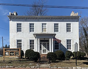
Fort Loudoun (Virginia)
Archaeological site in Virginia, United States
Distance: Approx. 1956 meters
Latitude and longitude: 39.18916667,-78.16388889
Fort Loudoun was a historic fortification of the French and Indian War, located in what is now Winchester, Virginia. The fort was built between 1756 and 1758 under the supervision of George Washington, then a colonel in the Virginia Regiment. It was named for John Campbell, 4th Earl of Loudoun, who commanded the British forces in North America for a time during the war.

Beth El Congregation (Winchester, Virginia)
Reform synagogue in Winchester, Virginia, US
Distance: Approx. 1582 meters
Latitude and longitude: 39.1925,-78.16611111
Beth El Congregation is a Reform Judaism congregation located at 520 Fairmont Avenue in Winchester, Virginia, in the United States. The local Jewish community developed in the late-19th century. They were mostly merchants who observed dietary laws (kosher), often having to travel to Baltimore for supplies.
Weather in this IP's area
clear sky
-7 Celsius
-7 Celsius
-9 Celsius
-6 Celsius
1024 hPa
61 %
1024 hPa
992 hPa
10000 meters
0.89 m/s
1.79 m/s
283 degree
