Country:
 USA
USARegion:
City:
Latitude and Longitude:
Time Zone:
Postal Code:
IP information under different IP Channel
ip-api
Country
Region
City
ASN
Time Zone
ISP
Blacklist
Proxy
Latitude
Longitude
Postal
Route
IPinfo
Country
Region
City
ASN
Time Zone
ISP
Blacklist
Proxy
Latitude
Longitude
Postal
Route
MaxMind
Country
Region
City
ASN
Time Zone
ISP
Blacklist
Proxy
Latitude
Longitude
Postal
Route
Luminati
Country
USASN
Time Zone
America/Chicago
ISP
DATABANK-DFW
Latitude
Longitude
Postal
db-ip
Country
Region
City
ASN
Time Zone
ISP
Blacklist
Proxy
Latitude
Longitude
Postal
Route
ipdata
Country
Region
City
ASN
Time Zone
ISP
Blacklist
Proxy
Latitude
Longitude
Postal
Route
Popular places and events near this IP address

Rocky Ridge, Utah
Town in the state of Utah, United States
Distance: Approx. 6618 meters
Latitude and longitude: 39.925,-111.82638889
Rocky Ridge is a town on the northeastern edge of Juab County, Utah, United States. As of the 2010 census it had a population of 733, and in 2018 the estimated population was 833. The town is located on the northern edge of the Juab Valley in the eastern foothills of the Wasatch Range, but entirely west of Interstate 15 (I‑15).

Genola, Utah
Town in Utah, United States
Distance: Approx. 3752 meters
Latitude and longitude: 39.99305556,-111.83638889
Genola ( jə-NOH-lə) is a town in Utah County, Utah, United States. It is part of the Provo–Orem Metropolitan Statistical Area. The population was 1,370 at the 2010 census.

Payson, Utah
City in Utah, United States
Distance: Approx. 8498 meters
Latitude and longitude: 40.03888889,-111.73305556
Payson is a city in Utah County, Utah, United States. It is part of the Provo–Orem Metropolitan Statistical Area. The population was 21,101 at the 2020 census.

Santaquin, Utah
City in Utah, United States
Distance: Approx. 1131 meters
Latitude and longitude: 39.97472222,-111.78444444
Santaquin ( SAN-tə-kwin) is a city in Utah and Juab counties in the U.S. state of Utah. It is part of the Provo–Orem metropolitan area. The population was 13,725 at the 2020 census.

Spring Lake, Utah
Census-designated place in Utah County, Utah, United States
Distance: Approx. 4646 meters
Latitude and longitude: 40.00027778,-111.74861111
Spring Lake is a census-designated place (CDP) in southern Utah County, Utah, United States. It is part of the Provo–Orem Metropolitan Statistical Area. The population was 458 at the 2010 census.

Tintic Standard Reduction Mill
United States historic place
Distance: Approx. 5608 meters
Latitude and longitude: 39.95748,-111.855
The Tintic Standard Reduction Mill—also known as the Tintic Mill or Harold Mill—built in 1920, and only operating from 1921 to 1925, is an abandoned refinery or concentrator located on the west slope of Warm Springs Mountain on the southern edge of Genola, Utah, United States. In 2002, the Utah Department of Environmental Quality tested the soil and found it contained high levels of arsenic and lead, which can lead to serious health problems and even death.
West Mountain (Utah County, Utah)
Mountain in Utah County, Utah, United States
Distance: Approx. 8899 meters
Latitude and longitude: 40.05541007,-111.82950971
West Mountain is a mountain in Utah, United States that is located 15.35 miles (25 km) southwest of the city of Provo, and 4.7 miles (8 km) west of the community of Benjamin. It is home to a radio station tower for KTCE, an FM station licensed to Payson and operating on 92.1 MHz. The mountain is also home to various FM radio translators and an observatory used by students from Brigham Young University (BYU).
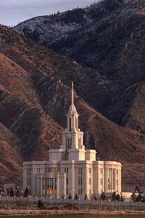
Payson Utah Temple
Distance: Approx. 5951 meters
Latitude and longitude: 40.01875556,-111.74835278
The Payson Utah Temple is a temple of the Church of Jesus Christ of Latter-day Saints in Payson, Utah. The temple is located on the southernmost edge of Utah's Wasatch Front, and is the 15th dedicated temple in the state.
Liberty Safe
American safe manufacturer
Distance: Approx. 8014 meters
Latitude and longitude: 40.043655,-111.752853
Liberty Safe and Security Products, Inc., doing business as Liberty Safe, is a residential and commercial safe manufacturer located in Payson, Utah, United States.

Payson Presbyterian Church
Historic church in Utah, United States
Distance: Approx. 8268 meters
Latitude and longitude: 40.03527778,-111.73166667
The Payson Presbyterian Church at 160 South Main Street in Payson, Utah, United States was built in 1882. It has also been known as Payson Bible Church. It was listed on the National Register of Historic Places (NRHP) in 1986; the listing included two contributing buildings.

Santaquin Junior High School
United States historic place
Distance: Approx. 1994 meters
Latitude and longitude: 39.97388889,-111.77388889
The Santaquin Junior High School, located in Santaquin, Utah, United States, was built in 1935 as a Public Works Administration (PWA) project. It was listed on the National Register of Historic Places in 1985. It is a two-story brick school.
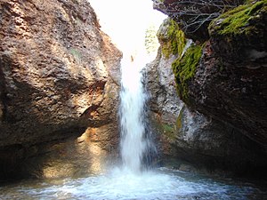
Peteetneet Creek
Stream in Utah County, Utah
Distance: Approx. 8398 meters
Latitude and longitude: 40.03472222,-111.72861111
Peteetneet Creek is a stream in Payson Canyon, south of Payson, Utah, United States.
Weather in this IP's area
moderate rain
5 Celsius
2 Celsius
3 Celsius
5 Celsius
1010 hPa
92 %
1010 hPa
842 hPa
81 meters
3.35 m/s
4.08 m/s
314 degree
100 %
07:41:13
18:42:53