172.98.130.121 - IP Lookup: Free IP Address Lookup, Postal Code Lookup, IP Location Lookup, IP ASN, Public IP
Country:
Region:
City:
Location:
Time Zone:
Postal Code:
IP information under different IP Channel
ip-api
Country
Region
City
ASN
Time Zone
ISP
Blacklist
Proxy
Latitude
Longitude
Postal
Route
Luminati
Country
Region
mi
City
okemos
ASN
Time Zone
America/Detroit
ISP
XIBER-LLC
Latitude
Longitude
Postal
IPinfo
Country
Region
City
ASN
Time Zone
ISP
Blacklist
Proxy
Latitude
Longitude
Postal
Route
IP2Location
172.98.130.121Country
Region
michigan
City
okemos
Time Zone
America/Detroit
ISP
Language
User-Agent
Latitude
Longitude
Postal
db-ip
Country
Region
City
ASN
Time Zone
ISP
Blacklist
Proxy
Latitude
Longitude
Postal
Route
ipdata
Country
Region
City
ASN
Time Zone
ISP
Blacklist
Proxy
Latitude
Longitude
Postal
Route
Popular places and events near this IP address

Meridian Charter Township, Michigan
Charter township in Michigan, United States
Distance: Approx. 2218 meters
Latitude and longitude: 42.72694444,-84.415
Meridian Charter Township is a charter township of Ingham County in the U.S. state of Michigan. As of the 2020 census, the township had a population of 43,916. The township is named after the Michigan meridian, which comprises the eastern border of the township.

Okemos, Michigan
Census-designated place in Michigan, US
Distance: Approx. 624 meters
Latitude and longitude: 42.70583333,-84.41361111
Okemos ( OH-kə-məss) is a census-designated place (CDP) in Ingham County in the U.S. state of Michigan. The population of the CDP was 25,121 at the 2020 census. Okemos is part of the urban area of Lansing–East Lansing, and is located nearby the campus of Michigan State University.

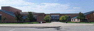
Okemos High School
Public high school in Okemos, Michigan, United States
Distance: Approx. 3847 meters
Latitude and longitude: 42.6845,-84.456
Okemos High School is a public high school in Okemos, Michigan, United States. It is the only high school in the Okemos Public Schools district. It is located southeast of the main campus of Michigan State University, between Bennett and Jolly Roads on the North and South, and Hulett and Hagadorn Roads on the East and West.

Michigan State University College of Human Medicine
Medical school of Michigan State University
Distance: Approx. 3962 meters
Latitude and longitude: 42.7226,-84.464764
The Michigan State University College of Human Medicine (MSUCHM) is an academic division of Michigan State University (MSU) that grants the Doctor of Medicine (MD) degree, emphasizing patient-centered care and a biopsychosocial approach to caring for patients. Required courses at the college reinforce the importance of ethics and professionalism in medicine. In 2013, U.S. News & World Report ranked the college 46th for primary care.
Meridian Mall
Shopping mall in Michigan, United States
Distance: Approx. 1943 meters
Latitude and longitude: 42.724885,-84.418774
Meridian Mall is a super-regional shopping mall located in Okemos, Meridian Township, a suburb of Lansing, Michigan, United States. It opened in 1969, the same year as its main competitor, Lansing Mall, on the other end of the Lansing metropolitan area. The mall originally featured the J.W. Knapp Company and Woolco as its anchor stores, and underwent many expansions over the years.

Haslett High School
Distance: Approx. 3737 meters
Latitude and longitude: 42.739435,-84.406801
Haslett High School is a public high school located in Haslett, Michigan. It is the only high school in the Haslett Public Schools district. It is located a few miles northeast of Michigan State University on Marsh Road between Haslett Road and Grand River Avenue.

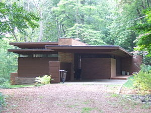
Donald Schaberg House
House in Okemos, Michigan
Distance: Approx. 2618 meters
Latitude and longitude: 42.709159,-84.388969
Designed by America's famous architect Frank Lloyd Wright, the Schaberg House was commissioned in 1950 by Donald and Mary Lou Schaberg. The house is an example of Wright's now-famous Usonian style. The house is located in Okemos, Ingham County, central-southern Michigan.

Michigan State University College of Veterinary Medicine
Veterinary school in Michigan, US
Distance: Approx. 4406 meters
Latitude and longitude: 42.722644,-84.470676
The Michigan State University College of Veterinary Medicine (CVM) is a veterinary college in the United States that was founded in 1910 and awards about 100 Doctor of Veterinary Medicine (DVM) degrees each year. It is the only veterinary college in Michigan. It is composed of the departments of Large Animal Clinical Sciences, Small Animal Clinical Sciences, Microbiology, Pharmacology and Toxicology, Physiology, and Pathobiology and Diagnostic Investigation.

Goetsch–Winckler House
United States historic place
Distance: Approx. 1495 meters
Latitude and longitude: 42.70805556,-84.43916667
The Goetsch–Winckler House (also known as Goetsch–Winkler House) is a building that was designed by Frank Lloyd Wright, built in 1940. It is located at 2410 Hulett Road, Okemos, Michigan. The house is an example of Wright's later Usonian architectural style, and it is considered to be one of the most elegant.
Toumey Woods
Natural area in the U.S. state of Michigan
Distance: Approx. 3632 meters
Latitude and longitude: 42.70373,-84.465
Toumey Woods, also called the Toumey Woodlot, is a 24-acre (9.7 ha) tract of beech-maple forest on the campus of Michigan State University in East Lansing, Michigan. 13.5 acres (5.5 ha) of the property are classified as old-growth woodland, and were listed as a United States National Natural Landmark in 1976.

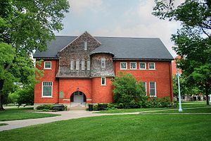
Eustace Hall
United States historic place
Distance: Approx. 2378 meters
Latitude and longitude: 42.69888889,-84.4475
Formerly known as Eustace Hall, Eustace-Cole Hall located on Laboratory Row is the only building on Michigan State University's main campus in East Lansing, Michigan that is on the National Register of Historic Places. Designed in a mix of "Queen Anne massing, Richardsonian Romanesque features, and Shingle Style", it was built in 1888 as the Horticultural Laboratory Building. Its design has been variously attributed to noted MSU alumnus and noted horticulturist Liberty Hyde Bailey and to Lansing architect William Appleyard It housed the horticulture department until 1924 when a new horticulture building (now known as Old Horticulture) was opened.

Williamston Downtown Historic District
United States historic place
Distance: Approx. 3067 meters
Latitude and longitude: 42.68916667,-84.44888889
The Williamston Downtown Historic District is a commercial historic district consisting of the first blocks of East and West Grand River Avenue, and the first block of South Putnam Street in Williamston, Michigan. The district was listed on the National Register of Historic Places in 2012.
Weather in this IP's area
light snow
-2 Celsius
-8 Celsius
-2 Celsius
-1 Celsius
1021 hPa
87 %
1021 hPa
988 hPa
10000 meters
6.69 m/s
12.35 m/s
350 degree
100 %

