Country:
 USA
USARegion:
City:
Latitude and Longitude:
Time Zone:
Postal Code:
IP information under different IP Channel
ip-api
Country
Region
City
ASN
Time Zone
ISP
Blacklist
Proxy
Latitude
Longitude
Postal
Route
IPinfo
Country
Region
City
ASN
Time Zone
ISP
Blacklist
Proxy
Latitude
Longitude
Postal
Route
MaxMind
Country
Region
City
ASN
Time Zone
ISP
Blacklist
Proxy
Latitude
Longitude
Postal
Route
Luminati
Country
USASN
Time Zone
America/Chicago
ISP
SWITCH-LTD
Latitude
Longitude
Postal
db-ip
Country
Region
City
ASN
Time Zone
ISP
Blacklist
Proxy
Latitude
Longitude
Postal
Route
ipdata
Country
Region
City
ASN
Time Zone
ISP
Blacklist
Proxy
Latitude
Longitude
Postal
Route
Popular places and events near this IP address

Corona del Mar, Newport Beach
Community of Newport Beach in California, United States
Distance: Approx. 1166 meters
Latitude and longitude: 33.588633,-117.878945
Corona del Mar (Spanish for "Crown of the Sea") is a seaside neighborhood in the city of Newport Beach, California. It generally consists of all the land on the seaward face of the San Joaquin Hills south of Avocado Avenue to the city limits, as well as the development of Irvine Terrace, just north of Avocado. Corona del Mar is known for its beaches, tide pools, cliffside views and village shops.

Fashion Island
Shopping mall in California, U.S.
Distance: Approx. 2289 meters
Latitude and longitude: 33.61591667,-117.87613889
Fashion Island is an outdoor regional shopping mall in Newport Beach, California. Opened in 1967 by The Irvine Company as the anchor to their master-planned Newport Center district, Fashion Island is anchored by Bloomingdale's, Macy's, Neiman Marcus, and Nordstrom.
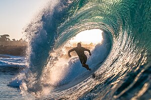
The Wedge (surfing)
Surfing location
Distance: Approx. 1198 meters
Latitude and longitude: 33.5925,-117.88222222
The Wedge is a spot located at the extreme southeast end of the Balboa Peninsula in Newport Beach, California known for its large waves that makes it a popular spot for surfing and bodysurfing. The Wedge is located at the intersection of the beach and the man-made jetty that forms the breakwater on the western side of Newport harbor entrance. When a south or south/southwest swell is running in the right size and direction, the Wedge can produce waves up to 30 feet (9.1 m) high.

Newport Center, Newport Beach, California
Business district of Newport Beach in California, United States
Distance: Approx. 2297 meters
Latitude and longitude: 33.616,-117.8761
Newport Center is a business, shopping, and entertainment district located on a high bluff overlooking Newport Harbor in Newport Beach, California, centered around the Fashion Island regional shopping mall. It was created in the early 1960s as part of William Pereira's master plan for the Irvine Ranch. Newport Center was created as the unofficial "downtown" of the Irvine Ranch, which at the time extended all the way down to Pacific Coast Highway.

Corona del Mar State Beach
Protected area
Distance: Approx. 534 meters
Latitude and longitude: 33.59361111,-117.875
Corona del Mar State Beach (Spanish for the Crown of the Sea) is a protected beach in the state park system of California, United States. It is located in Corona del Mar, Newport Beach, and operated by the city of Newport Beach. The 30-acre (12 ha) park was established in 1947.
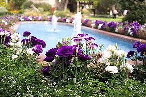
Sherman Library and Gardens
Botanical gardens in California, US
Distance: Approx. 782 meters
Latitude and longitude: 33.602427,-117.873409
The Sherman Library and Gardens are botanical gardens in Corona del Mar, California. The gardens are open to the public daily except Thanksigiving Day, Christmas Day and New Year's Day. An admission fee is charged.
Hoag Classic
Golf tournament
Distance: Approx. 2195 meters
Latitude and longitude: 33.613,-117.882
The Hoag Classic (formerly the Toshiba Classic) is a golf tournament on the PGA Tour Champions. The Hoag Classic is played annually in March in Newport Beach, California at the Newport Beach Country Club. Newport Beach Country Club was designed by William Francis Bell in 1954.

Kerckhoff Marine Laboratory
Laboratory at the California Institute of Technology
Distance: Approx. 863 meters
Latitude and longitude: 33.59725,-117.87918
The William G. Kerckhoff Marine Laboratory is owned and operated by the California Institute of Technology (Caltech). It is located 101 Dahlia Street, in the Corona del Mar district of Newport Beach, in Orange County, California.
Newport Sports Museum
Newport Sports Museum, in Newport Beach, California, USA, was closed in 2014
Distance: Approx. 1979 meters
Latitude and longitude: 33.61271999,-117.877241
The Newport Sports Museum was a sports museum in Newport Beach, California, USA. It closed in 2014.
China House of China Cove
Distance: Approx. 770 meters
Latitude and longitude: 33.5962,-117.8783
China House was a distinctive bright pink house with elaborate scrolling and curved Chinese architecture. It was built in 1927 in Newport Beach, California, by a Pasadena resident.
Newport Beach Civic Center and Park
Distance: Approx. 1552 meters
Latitude and longitude: 33.60984,-117.87198
The Newport Beach Civic Center and Park is a civic center and community park located in Newport Beach, California. It is situated on a 16-acre lot that is bordered by Avocado Avenue and MacArthur Boulevard.
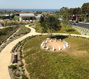
Bunnyhenge
Sculpture in California
Distance: Approx. 1695 meters
Latitude and longitude: 33.6112,-117.8711
Bunnyhenge is a public sculpture in Newport Beach, California depicting fourteen large white rabbits (of the desert cottontail species) sitting on their haunches in a circle. Two larger, 8 ft (2.4 m) rabbits outside the circle are also a part of the sculpture. Made of concrete and placed in the city's civic center, the sculpture garnered controversy when first built due to its improper allocation of city finances, costing $221,000.
Weather in this IP's area
haze
27 Celsius
29 Celsius
23 Celsius
33 Celsius
1014 hPa
65 %
1014 hPa
1010 hPa
6437 meters
4.12 m/s
8.23 m/s
220 degree
20 %
06:48:57
18:30:12