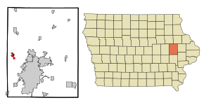
Country:
Region:
City:
Latitude and Longitude:
Time Zone:
Postal Code:
IP information under different IP Channel
ip-api
Country
Region
City
ASN
Time Zone
ISP
Blacklist
Proxy
Latitude
Longitude
Postal
Route
Luminati
Country
Region
ia
City
palo
ASN
Time Zone
America/Chicago
ISP
EIDG-AS1
Latitude
Longitude
Postal
IPinfo
Country
Region
City
ASN
Time Zone
ISP
Blacklist
Proxy
Latitude
Longitude
Postal
Route
db-ip
Country
Region
City
ASN
Time Zone
ISP
Blacklist
Proxy
Latitude
Longitude
Postal
Route
ipdata
Country
Region
City
ASN
Time Zone
ISP
Blacklist
Proxy
Latitude
Longitude
Postal
Route
Popular places and events near this IP address

Marion, Iowa
City in Iowa, United States
Distance: Approx. 2015 meters
Latitude and longitude: 42.03777778,-91.75972222
Marion is a city in Linn County, Iowa, United States. The population was 26,294 at the 2000 census and was 41,535 in 2020, an increase of 58%. The city is located next to Cedar Rapids and part of the Cedar Rapids Metropolitan Statistical Area.

Palo, Iowa
City in Iowa, United States
Distance: Approx. 2649 meters
Latitude and longitude: 42.06222222,-91.79305556
Palo is a city in Linn County, Iowa, United States. The population was 1,407 at the time of the 2020 census. It is part of the Cedar Rapids Metropolitan Statistical Area.

Duane Arnold Energy Center
Nuclear power plant located in Iowa
Distance: Approx. 6831 meters
Latitude and longitude: 42.10055556,-91.77722222
The Duane Arnold Energy Center (DAEC) was Iowa's only nuclear power plant. It is located on a 500-acre (200 ha) site on the west bank of the Cedar River, two miles (3.2 km) north-northeast of Palo, Iowa, USA, or eight miles (13 km) northwest of Cedar Rapids. DAEC entered operation in February 1975.
Xavier High School (Cedar Rapids, Iowa)
Private secondary school in Cedar Rapids, Iowa, United States
Distance: Approx. 5186 meters
Latitude and longitude: 42.02416667,-91.72472222
Xavier High School in Cedar Rapids, Iowa is the only Catholic high school in the local metropolitan area. It is affiliated with twelve area Catholic parishes and the Archdiocese of Dubuque. Xavier opened in 1998 after the merger of two previous Catholic high schools, Regis and LaSalle.
Fayette Township, Linn County, Iowa
Township in Linn County, Iowa, U.S.
Distance: Approx. 5848 meters
Latitude and longitude: 42.0897,-91.8044
Fayette Township is a township in Linn County, Iowa. The township's population as of the 2020 census was 1,720.
Monroe Township, Linn County, Iowa
Township in Linn County, Iowa, U.S.
Distance: Approx. 7127 meters
Latitude and longitude: 42.0778,-91.715
Monroe Township is a township in Linn County, Iowa.
Clinton Township, Linn County, Iowa
Township in Linn County, Iowa, U.S.
Distance: Approx. 4996 meters
Latitude and longitude: 41.9947,-91.7894
Clinton Township is a township in Linn County, Iowa.

Chain Lakes Bridge
United States historic place
Distance: Approx. 1388 meters
Latitude and longitude: 42.05016667,-91.77552778
The Chain Lakes Bridge is a historic structure located southeast of Palo, Iowa, United States. It carries a pedestrian trail for 370 feet (110 m) over the Cedar River. The Linn County Board of Supervisors began planning for this span in the early 1880s.

Taylor–Van Note House
Historic house in Iowa, United States
Distance: Approx. 4572 meters
Latitude and longitude: 42.04202778,-91.72880556
The Taylor–Van Note House, also known as Blairs Ferry Wayside Inn/Vanesther Place, is a historic building located in Cedar Rapids, Iowa, United States. Charles Taylor had this two-story, wood frame, vernacular Greek Revival house built in 1846. The family owned the house until 1888 when it was sold to Lazarus Van Note, whose family owned it as late as 1985.

Seminole Valley Farmstead
United States historic place
Distance: Approx. 6158 meters
Latitude and longitude: 42.00361111,-91.72722222
Seminole Valley Farmstead is a collection of historic farm buildings located in Seminole Valley Park on the north east side of Cedar Rapids, Iowa, United States. The historic designation includes the farmhouse (c. 1902–1903), summer kitchen, livestock barn, tool shed, ice house, chicken house, and smokehouse.
Hanging Bog State Preserve
State preserve in Iowa
Distance: Approx. 1576 meters
Latitude and longitude: 42.033,-91.767
Hanging Bog State Preserve is a 16-acre (6.5 ha) forest that is on the edge of the Cedar River valley in Iowa. It was deeded to The Nature Conservancy in 1968, and it became a state preserve in 1981. The bog has an area that is perennially wet because when water passes through the ground, there is a layer that the water cannot get through, causing the water to surface on a hillside and also form tufa.
Wickiup Hill
Native American archeological region near Toddville, Iowa
Distance: Approx. 5101 meters
Latitude and longitude: 42.083,-91.765
Wickiup Hill is a Native American archeological region near Toddville, in Linn County, Iowa. The area has the Wickiup Hill Outdoor Learning Center which was built where a Meskwaki village once stood. Wickiup Hill has been excavated by archeologists.
Weather in this IP's area
overcast clouds
8 Celsius
5 Celsius
6 Celsius
8 Celsius
1014 hPa
88 %
1014 hPa
985 hPa
10000 meters
4.63 m/s
310 degree
100 %
06:46:40
16:54:56