Country:
Region:
City:
Latitude and Longitude:
Time Zone:
Postal Code:
IP information under different IP Channel
ip-api
Country
Region
City
ASN
Time Zone
ISP
Blacklist
Proxy
Latitude
Longitude
Postal
Route
Luminati
Country
Region
pa
City
philadelphia
ASN
Time Zone
America/New_York
ISP
T-MOBILE-AS21928
Latitude
Longitude
Postal
IPinfo
Country
Region
City
ASN
Time Zone
ISP
Blacklist
Proxy
Latitude
Longitude
Postal
Route
db-ip
Country
Region
City
ASN
Time Zone
ISP
Blacklist
Proxy
Latitude
Longitude
Postal
Route
ipdata
Country
Region
City
ASN
Time Zone
ISP
Blacklist
Proxy
Latitude
Longitude
Postal
Route
Popular places and events near this IP address

Olney, Philadelphia
Neighborhood of Philadelphia in Pennsylvania, United States
Distance: Approx. 155 meters
Latitude and longitude: 40.034,-75.121
Olney ( or locally ) is a neighborhood in the North Philadelphia section of Philadelphia. It is roughly bounded by Roosevelt Boulevard to the south, Tacony Creek to the east, Godfrey Avenue to the north, and the railroad right-of-way west of 7th Street to the west. Although Olney is primarily a quiet residential neighborhood, portions do serve as major commercial centers for many surrounding groups.

Olney station (SEPTA)
SEPTA train station in Philadelphia, Pennsylvania, United States
Distance: Approx. 375 meters
Latitude and longitude: 40.032954,-75.123203
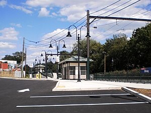
Olney station is a SEPTA Regional Rail station in Philadelphia, Pennsylvania. Located at Mascher Street and Tabor Road in the Olney neighborhood, it serves the Fox Chase Line. The station has a 61-space parking lot.

Adams Avenue Bridge
United States historic place
Distance: Approx. 972 meters
Latitude and longitude: 40.04194444,-75.11333333
The Adams Avenue Bridge is a historic bridge in Philadelphia, Pennsylvania. It carries Adams Avenue over the Tacony Creek in Tacony Creek Park. A two-lane, triple-span, closed-spandrel, filled stone arch bridge, built in 1901, it was listed on the National Register of Historic Places in 1988.
Feltonville School No. 2
United States historic place
Distance: Approx. 1164 meters
Latitude and longitude: 40.02444444,-75.12305556
Feltonville School No. 2, also known as the Feltonville School, is a historic school building located in the Feltonville neighborhood of Philadelphia, Pennsylvania. It was designed by architect Henry deCourcy Richards and built in 1908.
Olney Elementary School
United States historic place
Distance: Approx. 402 meters
Latitude and longitude: 40.0311,-75.1209
Olney Elementary School is an historic, American elementary school that is located in the Olney neighborhood of Philadelphia, Pennsylvania. It is part of the School District of Philadelphia. The building was added to the National Register of Historic Places in 1986.
Olney High School
United States historic place
Distance: Approx. 765 meters
Latitude and longitude: 40.0286,-75.1239
The Olney Charter High School, formerly the Aspira Charter School at Olney, and Olney High School, is a public high school that is located in the Olney section of Philadelphia, Pennsylvania. Previously part of the School District of Philadelphia, it was subsequently a charter high school; however, it reverted to a public high school beginning with the 2022-2023 school year. It was added to the National Register of Historic Places in 1986.
Andrew J. Morrison School
United States historic place
Distance: Approx. 1028 meters
Latitude and longitude: 40.0297,-75.1296
Andrew J. Morrison School is a historic school located in the Olney neighborhood of Philadelphia, Pennsylvania. It functions as a K–8 school under the School District of Philadelphia. The building was designed by Irwin T. Catharine and built in 1922–1924.
James Russell Lowell School (Philadelphia)
Historic elementary school in the Olney neighborhood of Philadelphia
Distance: Approx. 1096 meters
Latitude and longitude: 40.04055556,-75.12944444
The James Russell Lowell School is a historic, American elementary school that is located in the Olney neighborhood of Philadelphia, Pennsylvania. It is part of the School District of Philadelphia and was added to the National Register of Historic Places in 1988.
Thomas K. Finletter School
United States historic place
Distance: Approx. 1014 meters
Latitude and longitude: 40.04361111,-75.11944444
The Thomas K. Finletter Academics Plus School is an historic, American school that is located in the Olney neighborhood of Philadelphia, Pennsylvania. It is part of the School District of Philadelphia. It was added to the National Register of Historic Places in 1988.
Thomas Creighton School
United States historic place
Distance: Approx. 1240 meters
Latitude and longitude: 40.03491,-75.10476
The Universal Creighton Charter School is a historic school that is located in the Crescentville neighborhood of Philadelphia, Pennsylvania, United States. Currently in use as a charter school, this building was added to the National Register of Historic Places in 1988 as the Thomas Creighton School.
Philadelphia Koreatown
Neighborhood of Pennsylvania, United States
Distance: Approx. 155 meters
Latitude and longitude: 40.034,-75.121
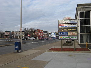
The first Philadelphia Koreatown (Korean: 필라델피아 코리아타운) is located around the Olney section of the city of Philadelphia, United States. Since the late 1980s, the Korean community has expanded northward, and it now straddles the border between North Philadelphia in Philadelphia proper and the northern suburb of Cheltenham, although many Korean-American businesses and organizations and some residents remain in Olney and adjoining neighborhoods. Upper Darby Township, bordering West Philadelphia, also has a large Korean-American population; meanwhile, a rapidly growing Korean population and commercial presence has emerged in suburban Cherry Hill, New Jersey since 2010, centered along Marlton Pike, attracted to the Cherry Hill Public Schools.

St. Alban's Church, Olney
Church in Olney, Pennsylvania, United States
Distance: Approx. 628 meters
Latitude and longitude: 40.03293029,-75.12638291
St. Alban's Church, Olney was a church of the Episcopal Diocese of Pennsylvania in the Olney section of North Philadelphia. Through the ministry and influence of its most significant rector, Archibald Campbell Knowles (1865-1961), St.
Weather in this IP's area
clear sky
13 Celsius
12 Celsius
12 Celsius
15 Celsius
1010 hPa
61 %
1010 hPa
1006 hPa
10000 meters
4.63 m/s
8.23 m/s
270 degree
06:46:23
16:44:11


