Country:
Region:
City:
Latitude and Longitude:
Time Zone:
Postal Code:
IP information under different IP Channel
ip-api
Country
Region
City
ASN
Time Zone
ISP
Blacklist
Proxy
Latitude
Longitude
Postal
Route
Luminati
Country
Region
ca
City
sandiego
ASN
Time Zone
America/Los_Angeles
ISP
T-MOBILE-AS21928
Latitude
Longitude
Postal
IPinfo
Country
Region
City
ASN
Time Zone
ISP
Blacklist
Proxy
Latitude
Longitude
Postal
Route
db-ip
Country
Region
City
ASN
Time Zone
ISP
Blacklist
Proxy
Latitude
Longitude
Postal
Route
ipdata
Country
Region
City
ASN
Time Zone
ISP
Blacklist
Proxy
Latitude
Longitude
Postal
Route
Popular places and events near this IP address

Mount Hope, San Diego
Community of San Diego in California
Distance: Approx. 1102 meters
Latitude and longitude: 32.7132,-117.1118
Mount Hope is an ethnically diverse, hilly urban neighborhood in San Diego, California. Located in the southeastern portion of the city, Mount Hope is named for the large municipal Mount Hope Cemetery, which encompasses approximately 115 acres (0.47 km2) of the community. The neighborhood contains a mixture of residential, industrial, commercial, and cemetery uses.

Golden Hill, San Diego
Neighborhood in San Diego, California
Distance: Approx. 1398 meters
Latitude and longitude: 32.718,-117.134
Golden Hill is a neighborhood in San Diego, California. It is located south of Balboa Park, north of Sherman Heights, Grant Hill and Stockton, and east of downtown. Golden Hill is one of San Diego's most historic and architecturally eclectic zones, with many pre-1900 homes and apartments.

South Park, San Diego
Distance: Approx. 1349 meters
Latitude and longitude: 32.721,-117.128
South Park is a neighborhood in San Diego, California, adjacent to the southeast corner of Balboa Park. It stands out in San Diego for its tree-lined streets and walkable business district. Predominantly a single-family residence area with some small apartment buildings and bungalow courts, it is noteworthy for its fine and varied collection of Craftsman and Spanish Colonial Revival style homes built between 1905 and 1930.

Albert Einstein Academy Charter School
School in San Diego, California
Distance: Approx. 1318 meters
Latitude and longitude: 32.720189,-117.129337
Albert Einstein Academy Charter School is an IB Primary Years Programme-certified charter school in San Diego, California, United States. It is a part of the San Diego Unified School District. Established in 2002, it is the only school in the district authorized as an IB-PYP school.
Mount Hope Cemetery (San Diego)
Cemetery in San Diego, California
Distance: Approx. 939 meters
Latitude and longitude: 32.71,-117.11277778
Mount Hope Cemetery is a cemetery in San Diego, California. It is believed to be named for its rolling hills and distant bay views; the community of Mount Hope adopted the name as well. It is adjacent to Greenwood Memorial Park.

25th & Commercial station
San Diego Trolley station
Distance: Approx. 1695 meters
Latitude and longitude: 32.705515,-117.140201
25th & Commercial station is a station on the Orange Line of the San Diego Trolley located in the Grant Hill neighborhood of San Diego, California. The stop is dedicated to Hispanic civil rights leader Cesar Chavez.

32nd & Commercial station
San Diego Trolley station
Distance: Approx. 527 meters
Latitude and longitude: 32.705389,-117.125115
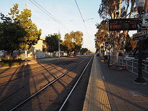
32nd & Commercial station is a station on the Orange Line of the San Diego Trolley located in the Stockton neighborhood of San Diego, California. The stop is located in an area where the light rail temporarily breaks from its street-level tracks and runs on a separate right-of-way around the Mt. Hope and Greenwood Cemeteries.

Grant Hill, San Diego
Community of San Diego in California
Distance: Approx. 1031 meters
Latitude and longitude: 32.7093,-117.1338
Grant Hill is a neighborhood in central San Diego, California, bordered by Golden Hill to the north, Stockton to the east, Sherman Heights to the west, and Logan Heights to the south. 30th Street connects Grant Hill to the neighborhood of Golden Hill. Grant Hill is part of the Southeastern Planning Area.

Stockton, San Diego
Community of San Diego in California
Distance: Approx. 220 meters
Latitude and longitude: 32.7108,-117.12475
Stockton is an urban neighborhood in central San Diego, California, bordered by Golden Hill to the north, Mountain View and Mt. Hope to the east, Grant Hill to the west, and Logan Heights to the south. I-15 forms the eastern boundary.
KNSN (AM)
Christian radio station in San Diego
Distance: Approx. 1734 meters
Latitude and longitude: 32.69416667,-117.12138889
KNSN (1240 kHz) is an AM radio station licensed to San Diego, California, United States. The station is owned by Crawford Broadcasting, through licensee Kiertron, Inc. It airs a brokered Christian radio format, mostly simulcast with co-owned KBRT (740 AM) in Costa Mesa.

Mountain View, San Diego
Community of San Diego in California
Distance: Approx. 1257 meters
Latitude and longitude: 32.703,-117.112
Mountain View is an urban community in the southeastern section of San Diego, California. It is bordered by Mount Hope and Greenwood Memorial Park on the north, Interstate 15 and the neighborhoods of Stockton and Logan Heights on the west, Interstate 805 and Lincoln Park on the east, and Southcrest and National City on the south. Major thoroughfares include Imperial Avenue and Ocean View Boulevard.

Memorial, San Diego
Neighborhood in California, United States
Distance: Approx. 1135 meters
Latitude and longitude: 32.7012,-117.1295
Memorial is an urban neighborhood in the southeastern area of San Diego, California. It is generally bounded by Imperial Avenue to the north, California State Route 15 to the east, Interstate 5 to the south, and 28th Street to the west. Major thoroughfares in the neighborhood include Commercial Street, Oceanview Boulevard, and National Avenue.
Weather in this IP's area
broken clouds
17 Celsius
16 Celsius
15 Celsius
18 Celsius
1013 hPa
61 %
1013 hPa
1011 hPa
10000 meters
8.75 m/s
290 degree
75 %
06:19:12
16:47:26