Country:
Region:
City:
Latitude and Longitude:
Time Zone:
Postal Code:
IP information under different IP Channel
ip-api
Country
Region
City
ASN
Time Zone
ISP
Blacklist
Proxy
Latitude
Longitude
Postal
Route
Luminati
Country
Region
tx
City
houston
ASN
Time Zone
America/Chicago
ISP
T-MOBILE-AS21928
Latitude
Longitude
Postal
IPinfo
Country
Region
City
ASN
Time Zone
ISP
Blacklist
Proxy
Latitude
Longitude
Postal
Route
db-ip
Country
Region
City
ASN
Time Zone
ISP
Blacklist
Proxy
Latitude
Longitude
Postal
Route
ipdata
Country
Region
City
ASN
Time Zone
ISP
Blacklist
Proxy
Latitude
Longitude
Postal
Route
Popular places and events near this IP address

Booker T. Washington High School (Houston)
School in Houston, Texas, United States
Distance: Approx. 2589 meters
Latitude and longitude: 29.821837,-95.398854
Booker T. Washington High School (nicknamed "Booker T.") is a secondary school located in the Independence Heights community in Houston, Texas. Washington serves grades 9 through 12, and is a part of the Houston Independent School District. The school has a neighborhood program that serves neighborhoods outside the 610 Loop and inside Beltway 8 in the northwest part of Houston, including the neighborhoods of Independence Heights, Highland Heights, and most of Acres Homes.
Oak Forest, Houston
Residential community in Houston, Texas, United States
Distance: Approx. 864 meters
Latitude and longitude: 29.82805556,-95.42527778
Oak Forest is a large residential community in northwest Houston, Texas, United States. Oak Forest is the third largest group of subdivisions in Harris County (behind Kingwood and Sharpstown).
Waltrip High School
Public high school in Houston, Texas, United States
Distance: Approx. 844 meters
Latitude and longitude: 29.819442,-95.434284
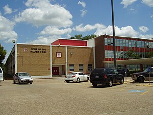
Stephen Pool Waltrip High School is a public high school located at 1900 West 34th Street in Houston, Texas, United States, 77018. Waltrip, which serves grades 9 through 12, is a part of the Houston Independent School District. Waltrip has Houston ISD's Research and Technology magnet program.
St. Pius X High School (Houston)
Private co-educational school in Houston, Texas, United States
Distance: Approx. 2813 meters
Latitude and longitude: 29.84333333,-95.41361111
St. Pius X High School (read as "Saint Pius the Tenth") is a Dominican, Catholic co-educational secondary school in Houston, Texas. St.
Lutheran North Academy
Private high school in Houston, Texas, U.S.
Distance: Approx. 622 meters
Latitude and longitude: 29.817885,-95.419795
Lutheran North Academy was a private Christian high school in Houston, Texas, in the Garden Oaks area. The school was affiliated with the Lutheran Church–Missouri Synod and was a member of the Texas Association of Private and Parochial Schools. It was operated by the Lutheran Education Association of Houston (LEAH) along with three other schools.

College of Health Care Professions
Private for-profit school in Texas, US
Distance: Approx. 2275 meters
Latitude and longitude: 29.8081,-95.4445
The College of Health Care Professions (CHCP) is a private for-profit school of allied health professions with its headquarters in Houston, Texas, and multiple campuses throughout the state.

Oriental Textile Mill
United States historic place
Distance: Approx. 2289 meters
Latitude and longitude: 29.80608333,-95.40847222
The Oriental Textile Mill, located at 2201 Lawrence Street in the Houston Heights neighborhood of Houston, Texas, was listed on the National Register of Historic Places on June 22, 1983. The mill is a complex of brick industrial buildings, with a four-story clock tower as its most distinguishing feature. Originally built in 1893 for a mattress manufacturing company, the site has seen several uses, including a textile mill, fiberglass manufacturing, a bakery, and mixed use small businesses and live/work spaces.

Houston Heights Waterworks Reservoir
United States historic place
Distance: Approx. 2582 meters
Latitude and longitude: 29.80416667,-95.40638889
The Houston Heights Waterworks Reservoir, located at West 20th Street and Nicolson Street in Houston, Texas, was listed on the National Register of Historic Places on June 22, 1983.

Arabic Immersion Magnet School
School in Houston, Texas
Distance: Approx. 1563 meters
Latitude and longitude: 29.8116,-95.4129
Arabic Immersion Magnet School (AIMS) is a magnet school in the Montrose area of Houston, Texas. A part of the Houston Independent School District (HISD), it currently covers elementary school grades. It uses a grant from the Qatar Foundation, and it is one of the first Arabic language immersion schools in the United States.
Live Oak Friends Meeting House
Quaker meeting house in Houston, Texas
Distance: Approx. 1228 meters
Latitude and longitude: 29.80944444,-95.42333333
Live Oak Friends Meeting House is a Quaker meeting house located at 1318 West 26th Street in the Heights area of Houston, Texas, United States. The meeting house, which was completed in December 2000, was designed and built to house the Live Oak Friends Meeting, which was formed in 1954. The building features a permanent installation by the artist James Turrell, known as the Skyspace or One Accord.

David A. Carden House
United States historic place
Distance: Approx. 2620 meters
Latitude and longitude: 29.80055556,-95.41083333
The David A. Carden House, at 718 W. 17th Ave. in the Houston Heights neighborhood of Houston, Texas, was built in 1918. It was listed on the National Register of Historic Places in 1990.
Gatlin's Fins & Feathers
Southern restaurant in Houston, Texas, U.S.
Distance: Approx. 2354 meters
Latitude and longitude: 29.82833333,-95.40305556
Gatlin's Fins & Feathers is a Southern restaurant in Houston, Texas. Established in July 2022, the business was included in The New York Times's 2023 list of the 50 best restaurants in the United States.
Weather in this IP's area
clear sky
11 Celsius
11 Celsius
10 Celsius
15 Celsius
1018 hPa
82 %
1018 hPa
1015 hPa
10000 meters
06:47:03
17:26:00


