Country:
Region:
City:
Latitude and Longitude:
Time Zone:
Postal Code:
IP information under different IP Channel
ip-api
Country
Region
City
ASN
Time Zone
ISP
Blacklist
Proxy
Latitude
Longitude
Postal
Route
Luminati
Country
Region
il
City
chicago
ASN
Time Zone
America/Chicago
ISP
T-MOBILE-AS21928
Latitude
Longitude
Postal
IPinfo
Country
Region
City
ASN
Time Zone
ISP
Blacklist
Proxy
Latitude
Longitude
Postal
Route
db-ip
Country
Region
City
ASN
Time Zone
ISP
Blacklist
Proxy
Latitude
Longitude
Postal
Route
ipdata
Country
Region
City
ASN
Time Zone
ISP
Blacklist
Proxy
Latitude
Longitude
Postal
Route
Popular places and events near this IP address

South Lawndale, Chicago
Community area in Chicago
Distance: Approx. 539 meters
Latitude and longitude: 41.85,-87.71
South Lawndale is a community area on the West Side of Chicago, Illinois. Over 80% of the residents are of Mexican descent and the community is home to the largest foreign-born Mexican population in Chicago.
Farragut Career Academy
School in Chicago, Cook County, Illinois, United States
Distance: Approx. 674 meters
Latitude and longitude: 41.8495,-87.7084
Farragut Career Academy High School is a public four-year high school located in the Little Village neighborhood on the West Side of Chicago, Illinois, United States. As a career academy, Farragut emphasizes a curriculum that combines academic instruction with work-study experiences and vocational training. In addition to Education-To-Careers clusters, Farragut is also home to the General Patton JROTC program, which functions as a school-within-a-school.

Kedzie station (CTA Pink Line)
Chicago rapid transit station, 1895–1954
Distance: Approx. 1020 meters
Latitude and longitude: 41.853964,-87.705408
Kedzie is a station on the Chicago Transit Authority's 'L' system, serving the Pink Line and the Lawndale neighborhood. It opened on March 10, 1902, as part of the Metropolitan West Side Elevated Railroad's Douglas Park branch. It was renovated between 2002 and 2004.

Central Park station (CTA)
Chicago rapid transit station
Distance: Approx. 449 meters
Latitude and longitude: 41.853839,-87.714842
Central Park is a station on the Chicago Transit Authority's 'L' system, serving the Pink Line and the North Lawndale neighborhood. The station opened on December 9, 1951, as a replacement for the closed Drake, Lawndale, and Homan stations.

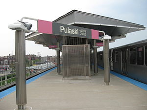
Pulaski station (CTA Pink Line)
Chicago rapid transit station
Distance: Approx. 769 meters
Latitude and longitude: 41.853732,-87.724311
Pulaski is an 'L' station on the CTA's Pink Line, located in the North Lawndale neighborhood. Pulaski opened on June 16, 1902, as part of the Douglas Park branch of the Metropolitan West Side Elevated Railroad. It served as the terminus of that line until its 1907 extension to 48th Avenue.
Five Houses on Avers District
Distance: Approx. 559 meters
Latitude and longitude: 41.8535,-87.72133333
The Five Houses on Avers District is a historic district in Chicago, Illinois, United States. The district was built between 1892 and 1894 by Frederick B. Townsend. It was designated a Chicago Landmark on March 2, 1994.
St. Gregory Episcopal School (Chicago)
Defunct Episcopalian school in Chicago, IL, USA
Distance: Approx. 285 meters
Latitude and longitude: 41.85241667,-87.71536111
St. Gregory Episcopal School was established in 1962 by the Rev. R. L. Whitehouse and Gordon L. Baker.

Shedd Park Fieldhouse
United States historic place
Distance: Approx. 48 meters
Latitude and longitude: 41.85027778,-87.71694444
The Shedd Park Fieldhouse is the historic fieldhouse in Shedd Park, a public park in the South Lawndale community area of Chicago, Illinois. John G. Shedd, for whom the park and fieldhouse are named, gave the city the land for the park. The Prairie School building was designed by William Drummond and built in 1917.
North Lawndale College Prep High School
School in Chicago, Illinois, United States
Distance: Approx. 1179 meters
Latitude and longitude: 41.8586,-87.7082
North Lawndale College Prep High School is a charter college preparatory high school in the North Lawndale community on the West Side of Chicago, Illinois. North Lawndale is a community that has struggled for decades with poverty. Schools suffered, along with the rest of the community, through white flight, the riots of the 1960s and the departure of businesses like Sears, Roebuck and Co.

K-Town Historic District
Historic district in Illinois, United States
Distance: Approx. 1148 meters
Latitude and longitude: 41.85305556,-87.72972222
The K-Town Historic District is a historic district listed on the National Register of Historic Places located in the North Lawndale community area in Chicago, Illinois. A mainly residential area, its borders are West Cullerton Street to the north, South Pulaski Road to the east, West Cermak Road to the south, and South Kostner Avenue to the west.

Anton Cermak House
Historic house in Illinois, United States
Distance: Approx. 186 meters
Latitude and longitude: 41.84833333,-87.71638889
The Anton Cermak House, located at 2348 S. Millard Avenue in Chicago's South Lawndale neighborhood, was the home of former Chicago mayor Anton Cermak. Frank A. Randak designed the American Foursquare house, which was built in 1902. Cermak moved to the house in 1923 and accomplished much of his political legacy while living there.
Killing of Adam Toledo
2021 police killing of a thirteen-year-old Latino boy in Chicago, Illinois, United States
Distance: Approx. 811 meters
Latitude and longitude: 41.84825,-87.707
On March 29, 2021, Adam Toledo, a 13-year-old Latino American boy, was shot and killed by Chicago Police Department (CPD) officer Eric Stillman in the Little Village neighborhood on the West Side of Chicago at 2:38am local time. On April 10, during a proffer reading in court for criminal charges filed against the adult who gave Toledo the handgun involved in the incident, a Cook County assistant prosecutor falsely told the judge that Toledo was holding the gun at the time Toledo was shot; the assistant prosecutor was later placed on administrative leave for this statement. On April 15, Stillman's body cam video recording was released, showing Toledo running away and dropping a handgun before he turned towards Stillman and raised his empty hands.
Weather in this IP's area
few clouds
11 Celsius
10 Celsius
10 Celsius
12 Celsius
1020 hPa
70 %
1020 hPa
998 hPa
10000 meters
1.34 m/s
2.68 m/s
1 degree
17 %
06:41:09
16:30:13