Country:
Region:
City:
Latitude and Longitude:
Time Zone:
Postal Code:
IP information under different IP Channel
ip-api
Country
Region
City
ASN
Time Zone
ISP
Blacklist
Proxy
Latitude
Longitude
Postal
Route
Luminati
Country
Region
ma
City
boston
ASN
Time Zone
America/New_York
ISP
T-MOBILE-AS21928
Latitude
Longitude
Postal
IPinfo
Country
Region
City
ASN
Time Zone
ISP
Blacklist
Proxy
Latitude
Longitude
Postal
Route
db-ip
Country
Region
City
ASN
Time Zone
ISP
Blacklist
Proxy
Latitude
Longitude
Postal
Route
ipdata
Country
Region
City
ASN
Time Zone
ISP
Blacklist
Proxy
Latitude
Longitude
Postal
Route
Popular places and events near this IP address

Dorchester Temple Baptist Church
Historic church in Massachusetts, United States
Distance: Approx. 765 meters
Latitude and longitude: 42.28836111,-71.07088889
Dorchester Temple Baptist Church is a historic African American Baptist church at 670 Washington Street in Boston, Massachusetts. It is now known as Global Ministries Christian Church. The church was designed in 1889 by Arthur H. Vinal in the shingle style and added to the National Historic Register in 1998.

Codman Square District
United States historic place
Distance: Approx. 716 meters
Latitude and longitude: 42.29027778,-71.07111111
The Codman Square District is a historic district in the Dorchester neighborhood of Boston, Massachusetts. It consists of four of the most prominent properties facing the main Codman Square intersection, where Talbot Avenue and Washington Street cross. The area has a long history as a major civic center in Dorchester, and is now one of the large neighborhood's major commercial hubs.
Talbot Avenue station
Train station in Dorchester, Boston, US
Distance: Approx. 343 meters
Latitude and longitude: 42.2932,-71.0784
Talbot Avenue station is an MBTA Commuter Rail station in Boston, Massachusetts. It serves the Fairmount Line. It is located near Codman Square in the Dorchester neighborhood.

Dorchester High School (Massachusetts)
School in Massachusetts, United States
Distance: Approx. 643 meters
Latitude and longitude: 42.28525833,-71.07598056
Dorchester High School is a defunct secondary school that was located in Dorchester, Boston, United States from 1852 to 2003.

Sherman Apartments Historic District
Historic district in Massachusetts, United States
Distance: Approx. 725 meters
Latitude and longitude: 42.29222222,-71.07138889
The Sherman Apartments Historic District encompasses four historic residential buildings on Washington and Lyndhurst Streets in the Dorchester neighborhood of Boston, Massachusetts. The district consists of three brick six-unit buildings constructed between 1904 and 1906 by Walter U. Sherman. They were built on the site of an 1831 Greek Revival school building, which was moved by Sherman to 18 Lyndhurst Street and converted into a residential duplex.

Walton and Roslin Halls
United States historic place
Distance: Approx. 807 meters
Latitude and longitude: 42.28694444,-71.07111111
Walton and Roslin Halls is a mixed-used commercial and residential building that was built in two parts. They are located at the corner of Washington and Walton Streets in the Dorchester neighborhood of Boston, Massachusetts, and extend south along Washington Street. The first of the two buildings, that at 3-5 Walton Street and 702-708 Washington, is a three-story brick and wood-frame structure built in 1897 to a design by Cornelius A. Russell; the southern portion was completed a year later.
TechBoston Academy
School in Dorchester, Massachusetts, United States
Distance: Approx. 648 meters
Latitude and longitude: 42.28527778,-71.07583333
Founded in 2002, TechBoston Academy (TBA) is a pilot school located in Dorchester, Massachusetts, United States that offers a college preparatory curriculum to students in grades 6–12. TBA immerses its 1,050 students to a wide span of technological resources such as laptops, Smartboards, PDAs, digital cameras, Google Apps for Education, and podcasting. TBA offers advanced courses that utilize this technology and cover topics such as digital art, Adobe graphic design applications, computer programming, and E-commerce.
Harambee Park
Distance: Approx. 490 meters
Latitude and longitude: 42.2923,-71.0851
Harambee Park is a park located in Dorchester and Mattapan, Boston. Originally known as Franklin Field, it was designed by Frederick Law Olmsted in order to give Bostonians a place to play sports, as well as prevent them from doing it at nearby Franklin Park. During its operation, it has hosted baseball, cricket, and a speedway.

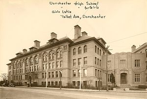
Dorchester High School for Girls
Defunct school in Massachusetts, United States
Distance: Approx. 799 meters
Latitude and longitude: 42.2903,-71.0701
Dorchester High School for Girls is a defunct four-year public high school that served students in ninth through twelfth grades, that was located in the Dorchester neighborhood of Boston, Massachusetts, United States from 1925 to 1953.

Second Church of Dorchester
Distance: Approx. 738 meters
Latitude and longitude: 42.290784,-71.070865
Second Church of Dorchester is a Church of the Nazarene in the historic Codman Square District of Dorchester in Boston, Massachusetts. In 1804 the church was founded as the Dorchester Meeting House Company by members from the First Parish Church of Dorchester. In 1806 the Harvard graduate John Codman was ordained as the church´s first minister.

Samuel Edelman Apartments
Historic residential building in Boston, Massachusetts
Distance: Approx. 374 meters
Latitude and longitude: 42.28833333,-71.07611111
The Samuel Edelman Apartments are a historic multifamily residential building at 97-103 Street in the Dorchester neighborhood of Boston, Massachusetts. It was built about 1908, during a period of major residential development of the area, and is a good example of Colonial Revival architecture in brick and stone. The building was listed on the National Register of Historic Places in 2013.

Thane Street Historic District
Historic district in Massachusetts, United States
Distance: Approx. 791 meters
Latitude and longitude: 42.29694444,-71.07638889
The Thane Street Historic District is a historic district encompassing a group of apartment houses in the Dorchester neighborhood of Boston, Massachusetts. Extending along Thane Street from Harvard Street, the area was developed in 1910, during a major Jewish migration, and includes a fine sample of Colonial Revival architecture. The district was listed on the National Register of Historic Places in 2020.
Weather in this IP's area
few clouds
13 Celsius
11 Celsius
12 Celsius
14 Celsius
1007 hPa
18 %
1007 hPa
1005 hPa
10000 meters
5.66 m/s
300 degree
20 %
06:35:38
16:22:37
