Country:
Region:
City:
Latitude and Longitude:
Time Zone:
Postal Code:
IP information under different IP Channel
ip-api
Country
Region
City
ASN
Time Zone
ISP
Blacklist
Proxy
Latitude
Longitude
Postal
Route
Luminati
Country
Region
ri
City
providence
ASN
Time Zone
America/New_York
ISP
T-MOBILE-AS21928
Latitude
Longitude
Postal
IPinfo
Country
Region
City
ASN
Time Zone
ISP
Blacklist
Proxy
Latitude
Longitude
Postal
Route
db-ip
Country
Region
City
ASN
Time Zone
ISP
Blacklist
Proxy
Latitude
Longitude
Postal
Route
ipdata
Country
Region
City
ASN
Time Zone
ISP
Blacklist
Proxy
Latitude
Longitude
Postal
Route
Popular places and events near this IP address
Elmwood, Providence, Rhode Island
United States historic place
Distance: Approx. 947 meters
Latitude and longitude: 41.8,-71.42
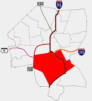
Elmwood is a neighborhood in the South Side of Providence, Rhode Island. The triangular region is demarcated by Broad Street, Elmwood Avenue, and Interstate 95.
South Side, Providence, Rhode Island
Distance: Approx. 990 meters
Latitude and longitude: 41.804,-71.424
The South Side of Providence, Rhode Island, originally South Providence, is a term frequently used to describe the collective region comprising the official neighborhoods of Upper and Lower South Providence, Elmwood and the West End. The name was first used in the 1830s when the New York, Providence and Boston Railroad established its first station at a pier on the Providence River on a point of land about one half mile south of downtown Providence. The station was named South Providence.

Richard Henry Deming House
Historic house in Rhode Island, United States
Distance: Approx. 718 meters
Latitude and longitude: 41.8025,-71.42722222
The Richard Henry Deming House is a historic home in Providence, Rhode Island. It is a 2+1⁄2-story wood-frame structure, and is one of the most elaborate Second Empire mansions in the city's Elmwood neighborhood. Built c.

Elmwood Historic District
Historic district in Rhode Island, United States
Distance: Approx. 842 meters
Latitude and longitude: 41.79833333,-71.42055556
The Elmwood Historic District encompasses two large residential sections of the Elmwood neighborhood of Providence, Rhode Island. The Elmwood area was mainly farmland until the mid-19th century, when its development as a residential area began, and these two sections represents well-preserved neighborhoods developed between about 1850 and 1920. The district was listed on the National Register of Historic Places in 1980.

Ontario Apartments
United States historic place
Distance: Approx. 968 meters
Latitude and longitude: 41.8,-71.41972222
The Ontario Apartments are an historic apartment complex located at 25-31 and 37-41 Ontario Street in Providence, Rhode Island. The apartments were designed by Page & Page, and built in 1925 and 1927 by Harry Soren in a Mission/Spanish Revival style. The apartments consist of two three-story, flat-roofed, wood-framed buildings.

Reservoir Avenue Sewage Pumping Station
United States historic place
Distance: Approx. 1013 meters
Latitude and longitude: 41.7875,-71.43222222
The Reservoir Avenue Sewage Pumping Station is an historic wastewater pumping facility on the south side of the junction of Reservoir and Pontiac Avenues in southern Providence, Rhode Island. From the street it looks like a single-story brick structure with a hip roof, and metal doorways on its north and east elevations. This building stands atop a substantial concrete substructure, which houses a dry well and wet well.
WIGV-LP
Radio station in Providence, Rhode Island
Distance: Approx. 927 meters
Latitude and longitude: 41.79083333,-71.42222222
WIGV-LP (96.5 FM) is a low-power FM radio station broadcasting a Spanish religious format. Licensed to Providence, Rhode Island, United States, the station is currently owned by Casa De Oracion Getsemani.

Central Diner
United States historic place
Distance: Approx. 892 meters
Latitude and longitude: 41.79102483,-71.422548
The Central Diner, also called Paula's Kitchen and formerly known as The Elmwood Diner, Liberty Elm Diner, Jenn's Elmwood Diner, Ole Elmwood Diner, or Worcester Lunch Car Company Diner #806, is a historic Worcester Lunch Car Company diner at 777 Elmwood Avenue in Providence, Rhode Island.

Saint Joseph's Hospital (Rhode Island)
Hospital in Rhode Island, United States
Distance: Approx. 1345 meters
Latitude and longitude: 41.80667753,-71.42166735
Saint Joseph's Hospital is a non-profit hospital in Providence, Rhode Island, which opened on April 6, 1892. The hospital is sponsored by the Roman Catholic Diocese of Providence. The Diocese merged St.

Reservoir, Providence, Rhode Island
Distance: Approx. 542 meters
Latitude and longitude: 41.794,-71.436
Reservoir is a neighborhood in southwest Providence, Rhode Island. It is bounded to the north and east by the Amtrak Northeast Corridor railroad tracks, and to the west and south by the municipal boundary with Cranston. The population of the neighborhood, as of 2000, was 2,963.

William J. Braitsch and Company Plant
United States historic place
Distance: Approx. 735 meters
Latitude and longitude: 41.80138889,-71.42444444
The William J. Braitsch and Company Plant is a historic industrial building at 472 Potters Avenue in Providence, Rhode Island. Built in 1892, it played a key role in the development of the silversmithing industry in the city. It was listed on the National Register of Historic Places in 2016.
Mashapaug Pond
Distance: Approx. 351 meters
Latitude and longitude: 41.79444444,-71.43361111
Mashapaug Pond is the largest freshwater pond in the city of Providence, Rhode Island. Over the past four hundred years, Mashapaug Pond has been a site of indigenous settlement and displacement, deforestation and agriculture, urban and industrial development, remediation and activism. The pond was a significant site to Indigenous people for centuries before and after 1636, when the Europeans settled in Rhode Island.
Weather in this IP's area
few clouds
14 Celsius
12 Celsius
13 Celsius
15 Celsius
1005 hPa
22 %
1005 hPa
1003 hPa
10000 meters
5.66 m/s
310 degree
20 %
06:35:49
16:25:14
