Country:
Region:
City:
Latitude and Longitude:
Time Zone:
Postal Code:
IP information under different IP Channel
ip-api
Country
Region
City
ASN
Time Zone
ISP
Blacklist
Proxy
Latitude
Longitude
Postal
Route
Luminati
Country
Region
fl
City
tampa
ASN
Time Zone
America/New_York
ISP
T-MOBILE-AS21928
Latitude
Longitude
Postal
IPinfo
Country
Region
City
ASN
Time Zone
ISP
Blacklist
Proxy
Latitude
Longitude
Postal
Route
db-ip
Country
Region
City
ASN
Time Zone
ISP
Blacklist
Proxy
Latitude
Longitude
Postal
Route
ipdata
Country
Region
City
ASN
Time Zone
ISP
Blacklist
Proxy
Latitude
Longitude
Postal
Route
Popular places and events near this IP address

ZooTampa at Lowry Park
Nonprofit zoo in Tampa, Florida
Distance: Approx. 1434 meters
Latitude and longitude: 28.01333333,-82.46944444
ZooTampa at Lowry Park (formerly known as Lowry Park Zoo or Lowry Park Zoological Garden) is a 63-acre (25 ha) nonprofit zoo located in Tampa, Florida. In 2009, Lowry Park Zoo was voted the #1 Family Friendly Zoo in the US by Parents Magazine, and is recognized by the State of Florida as the center for Florida wildlife conservation and biodiversity (HB 457). The zoo is operated by the Lowry Park Zoological Society, an independent 501(c)(3) charitable organization.
George D. Chamberlain High School
Public secondary school in Tampa, , Florida, United States
Distance: Approx. 1826 meters
Latitude and longitude: 28.0347,-82.4669
George D. Chamberlain High School is a public high school in Tampa, Florida, United States. It was opened in 1956 on North Boulevard (on the corner of Busch Boulevard). The school is named in honor of George D. Chamberlain, who served for several years as a trustee for the Hillsborough County School System.

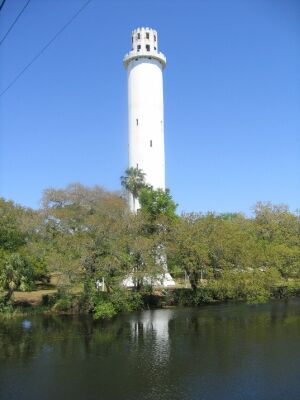
Sulphur Springs Water Tower
Distance: Approx. 172 meters
Latitude and longitude: 28.021397,-82.458897
Sulphur Springs Water Tower is a landmark of Tampa, Florida. It stands 214 feet (65 m) tall, with a foundation 45 feet (14 m) deep which makes it visible from nearby Interstate 275 and much of the rest of Sulphur Springs. It's located in the historic district of Sulphur Springs.

Sulphur Springs (Tampa)
Neighborhood in Hillsborough, Florida, United States
Distance: Approx. 591 meters
Latitude and longitude: 28.02083333,-82.45138889
Sulphur Springs is a neighborhood and district located within the city limits of Tampa, Florida. At the time of the 2010 census, there were 5,727 residents, down somewhat from the 2000 census count of 6,308. In the late 19th century the mineral springs were a draw.
Lowry Park Central
Neighborhood in Hillsborough, Florida, United States
Distance: Approx. 1527 meters
Latitude and longitude: 28.0275,-82.47083333
Lowry Park Central is a neighborhood within the city limits of Tampa, Florida. As of the 2010 census the neighborhood had a population of 3,125. The ZIP Codes serving the neighborhood are 33603 and 33604.
Lowry Park North
Neighborhood in Hillsborough, Florida, United States
Distance: Approx. 1431 meters
Latitude and longitude: 28.02,-82.47194444
Lowry Park North is a neighborhood within the city limits of Tampa, Florida. As of the 2010 census the neighborhood had a population of 5,936. The ZIP Codes serving the neighborhood are 33604 and 33612.

Old Seminole Heights
Neighborhood in Hillsborough, Florida, United States
Distance: Approx. 1780 meters
Latitude and longitude: 28.00527778,-82.45222222
Old Seminole Heights is a neighborhood within the city limits of Tampa, in the U.S. state of Florida. The neighborhood is one of three which comprise the greater Seminole Heights district within the city. As of the 2010 census the neighborhood had a population of 14,729.
Harvey Heights (Tampa)
Neighborhood in Hillsborough, Florida, United States
Distance: Approx. 1758 meters
Latitude and longitude: 28.03638889,-82.45722222
Harvey Heights is a neighborhood in the northern area of Tampa, Florida, which represents District 7 of the Tampa City Council. The 2000 census numbers were unavailable; however, the latest estimated population was 285.

Fern Cliff
Neighborhood in Hillsborough, Florida, United States
Distance: Approx. 1612 meters
Latitude and longitude: 28.01888889,-82.44111111
Fern Cliff is a neighborhood in the Sulphur Springs section of Tampa, Florida, which represents District 5 of the Tampa City Council. The 2000 census numbers were unavailable, however, the latest estimated population was 1,083.

Captain William Parker Jackson House
Historic house in Florida, United States
Distance: Approx. 1618 meters
Latitude and longitude: 28.00674,-82.45244
Captain William Parker Jackson House is a historic residence in the Seminole Heights area of Tampa, Florida. An 1870s farmhouse, it was once owned by prominent Tampa pioneers. It is listed on the National Register of Historic Places.

Sulphur Springs Museum and Heritage Center
Distance: Approx. 898 meters
Latitude and longitude: 28.01958333,-82.44833333
The Sulphur Springs Museum and Heritage Center is a local history museum in the Sulphur Springs neighborhood of Tampa, Florida. The museum was founded in 2006. It moved to its current location inside Mann-Wagnon Memorial Park in 2017.
Ultimate Medical Academy
Healthcare school in Florida, United States
Distance: Approx. 1579 meters
Latitude and longitude: 28.03478,-82.4576
Ultimate Medical Academy (UMA) is a nonprofit career education school that grants associate degrees and diplomas in allied health professions. UMA also has a continuing medical education (CME) division that provides training to more than 50,000 physicians, nurses and other medical professionals annually. As of July 2024, UMA has more than 90,000 alumni and more than 15,000 students nationwide.
Weather in this IP's area
clear sky
23 Celsius
22 Celsius
21 Celsius
24 Celsius
1012 hPa
57 %
1012 hPa
1012 hPa
10000 meters
2.57 m/s
30 degree
06:52:00
17:37:17