Country:
 France
Region:
City:
Latitude and Longitude:
Time Zone:
Postal Code:
IP information under different IP Channel
ip-api
Country
Region
City
ASN
Time Zone
ISP
Blacklist
Proxy
Latitude
Longitude
Postal
Route
IPinfo
Country
Region
City
ASN
Time Zone
ISP
Blacklist
Proxy
Latitude
Longitude
Postal
Route
MaxMind
Country
Region
City
ASN
Time Zone
ISP
Blacklist
Proxy
Latitude
Longitude
Postal
Route
Luminati
Country
FRASN
Time Zone
Europe/Paris
ISP
K-NET SARL
Latitude
Longitude
Postal
db-ip
Country
Region
City
ASN
Time Zone
ISP
Blacklist
Proxy
Latitude
Longitude
Postal
Route
ipdata
Country
Region
City
ASN
Time Zone
ISP
Blacklist
Proxy
Latitude
Longitude
Postal
Route
Popular places and events near this IP address

Bonneville, Haute-Savoie
Subprefecture of Haute-Savoie, Auvergne-Rhône-Alpes, France
Distance: Approx. 459 meters
Latitude and longitude: 46.0797,6.4014
Bonneville (French pronunciation: [bɔnvil] ; Arpitan: Bônavela) is a subprefecture of the Haute-Savoie department in the Auvergne-Rhône-Alpes region in Eastern France. In 2018, the commune had a population of 12,557.

Arrondissement of Bonneville
Arrondissement in Auvergne-Rhône-Alpes, France
Distance: Approx. 738 meters
Latitude and longitude: 46.07361111,6.40833333
The arrondissement of Bonneville is an arrondissement of France in the Haute-Savoie department in the Auvergne-Rhône-Alpes region. It has 60 communes. Its population is 186,945 (2016), and its area is 1,558.2 km2 (601.6 sq mi).

Saint-Pierre-en-Faucigny
Commune in Auvergne-Rhône-Alpes, France
Distance: Approx. 3426 meters
Latitude and longitude: 46.0606,6.3731
Saint-Pierre-en-Faucigny (French pronunciation: [sɛ̃ pjɛʁ ɑ̃ fosiɲi]) is a commune in the Haute-Savoie department in the Auvergne-Rhône-Alpes region in Eastern France. It is located in the historical province of Faucigny in Savoy hence its name. The town had 6,389 inhabitants in 2016.

Ayse
Commune in Auvergne-Rhône-Alpes, France
Distance: Approx. 2357 meters
Latitude and longitude: 46.0833,6.4375
Ayse (sometimes written Ayze, French pronunciation: [aiz]; Arpitan: Aïze) is a commune of the Haute-Savoie department in the Auvergne-Rhône-Alpes region in south-eastern France.

Saint-Jean-de-Tholome
Commune in Auvergne-Rhône-Alpes, France
Distance: Approx. 3662 meters
Latitude and longitude: 46.1125,6.3983
Saint-Jean-de-Tholome (French pronunciation: [sɛ̃ ʒɑ̃ də tɔlom]; Arpitan: San-Dyan) is a commune in the Haute-Savoie department in the Auvergne-Rhône-Alpes region in south-eastern France.
Brizon, Haute-Savoie
Commune in Auvergne-Rhône-Alpes, France
Distance: Approx. 4571 meters
Latitude and longitude: 46.0489,6.4456
Brizon (French pronunciation: [bʁizɔ̃]; Arpitan: Beurzon) is a commune in the Haute-Savoie département in the Auvergne-Rhône-Alpes region in south-eastern France. The Col de Solaison ski area is within the commune.
Saint-Laurent, Haute-Savoie
Commune in Auvergne-Rhône-Alpes, France
Distance: Approx. 5174 meters
Latitude and longitude: 46.0475,6.3597
Saint-Laurent (French pronunciation: [sɛ̃ loʁɑ̃] ) is a commune in the Haute-Savoie department in the Auvergne-Rhône-Alpes region in south-eastern France.

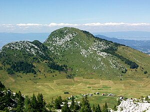
Le Môle
Mountain in France
Distance: Approx. 4716 meters
Latitude and longitude: 46.10666667,6.455
Le Môle (French pronunciation: [lə mol]) is a mountain of the Chablais Alps in the Haute-Savoie department of France which dominates the area around the town of Bonneville. The communes of Ayze, La Tour, Saint-Jean-de-Tholome, Marignier, Saint-Jeoire-en-Faucigny, Viuz-en-Sallaz, Peillonnex, and Faucigny encircle it. It rises to 1,863 metres and affords an excellent 360-degree view of the surrounding region.
Pointe d'Andey
Distance: Approx. 4248 meters
Latitude and longitude: 46.04277778,6.41805556
Pointe d'Andey (French pronunciation: [pwɛ̃t dɑ̃dɛ]) is a mountain of Haute-Savoie, France. It lies in the Bornes Massif range. It has an altitude of 1877 metres above sea level.

Canton of Bonneville
Administrative division of Haute-Savoie, France
Distance: Approx. 210 meters
Latitude and longitude: 46.08,6.41
The canton of Bonneville (French: Canton de Bonneville) is a canton (an administrative division) in the central part of the Haute-Savoie department in Southeastern France. Its seat is Bonneville. Its borders were modified at the canton reorganisation that came into effect in March 2015.

Bonneville station
Railway station in the commune of Bonneville
Distance: Approx. 762 meters
Latitude and longitude: 46.07777194,6.41652389
Bonneville station (French: Gare de Bonneville) is a railway station in the commune of Bonneville, in the French department of Haute-Savoie.

Saint-Pierre-en-Faucigny station
Railway station in Saint-Pierre-en-Faucigny, France
Distance: Approx. 3365 meters
Latitude and longitude: 46.05934389,6.37575306
Saint-Pierre-en-Faucigny station (French: Gare de Saint-Pierre-en-Faucigny) is a railway station in the commune of Saint-Pierre-en-Faucigny, in the French department of Haute-Savoie.
Weather in this IP's area
scattered clouds
14 Celsius
13 Celsius
13 Celsius
15 Celsius
1018 hPa
89 %
1018 hPa
966 hPa
10000 meters
1.7 m/s
1.53 m/s
131 degree
39 %
07:17:50
19:38:24