Country:
 Australia
Region:
City:
Latitude and Longitude:
Time Zone:
Postal Code:
IP information under different IP Channel
ip-api
Country
Region
City
ASN
Time Zone
ISP
Blacklist
Proxy
Latitude
Longitude
Postal
Route
IPinfo
Country
Region
City
ASN
Time Zone
ISP
Blacklist
Proxy
Latitude
Longitude
Postal
Route
MaxMind
Country
Region
City
ASN
Time Zone
ISP
Blacklist
Proxy
Latitude
Longitude
Postal
Route
Luminati
Country
AURegion
nsw
ASN
Time Zone
Australia/Sydney
ISP
Gilead Sciences, Inc.
Latitude
Longitude
Postal
db-ip
Country
Region
City
ASN
Time Zone
ISP
Blacklist
Proxy
Latitude
Longitude
Postal
Route
ipdata
Country
Region
City
ASN
Time Zone
ISP
Blacklist
Proxy
Latitude
Longitude
Postal
Route
Popular places and events near this IP address

Galvin railway station
Former railway station in Victoria, Australia
Distance: Approx. 3312 meters
Latitude and longitude: -37.85527778,144.80722222
Galvin railway station is a closed railway station which was located on the Werribee line of the Melbourne suburban rail system in Australia. It was located adjacent to Maidstone Street, Altona, and was situated between Paisley and Laverton stations.

Laverton, Victoria
Suburb of Melbourne, Victoria, Australia
Distance: Approx. 637 meters
Latitude and longitude: -37.858,144.773
Laverton established in 1886, is a suburb of Melbourne, Victoria, Australia, 17 km (11 mi) south-west of Melbourne's Central Business District, located within the Cities of Hobsons Bay and Wyndham local government areas. Laverton recorded a population of 4,760 at the 2021 census. It was home to the RAAF Base (RAAF Williams), and covers 148 ha in the suburb of Laverton.

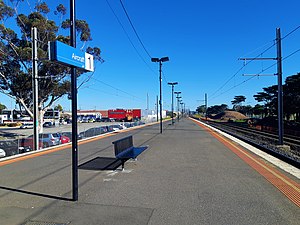
Laverton railway station, Melbourne
Railway station in Laverton, Melbourne, Victoria, Australia
Distance: Approx. 111 meters
Latitude and longitude: -37.8638,144.7722
Laverton railway station is a commuter railway station on the Werribee line, which is part of the Melbourne railway network. It serves the western suburb of Laverton in Melbourne, Victoria, Australia. Laverton station is a ground level premium station, featuring three platforms, an island platform with two faces and one side platform.
Aircraft railway station
Railway station in Victoria, Australia
Distance: Approx. 952 meters
Latitude and longitude: -37.8666,144.7609
Aircraft railway station is a commuter railway station on the Werribee line, which is part of the Melbourne railway network. It serves the western suburb of Laverton, in Melbourne, Victoria, Australia. Aircraft station is a ground level unstaffed station, featuring an island platform.

Altona Meadows, Victoria
Suburb of Melbourne, Victoria, Australia
Distance: Approx. 1604 meters
Latitude and longitude: -37.875,144.782
Altona Meadows is a suburb in Melbourne, Victoria, Australia, 17 km (11 mi) south-west of Melbourne's Central Business District, located within the City of Hobsons Bay local government area. Altona Meadows recorded a population of 18,479 at the 2021 census. Located partly within Altona Meadows, Cheetham Wetlands is a large park with numerous boardwalks traversing its network of lagoons.
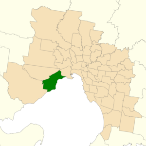
Electoral district of Altona
State electoral district of Victoria, Australia
Distance: Approx. 2459 meters
Latitude and longitude: -37.88333333,144.78333333
The electoral district of Altona was one of the electoral districts of Victoria, Australia, for the Victorian Legislative Assembly. It covered an area of 79 square kilometres (31 sq mi) in western Melbourne, and included the suburbs of Altona, Altona Meadows, Laverton, Point Cook, Seabrook and Seaholme. It also included the RAAF Williams airbase and the Point Cook Coastal Park.
Melbourne Ballpark
Distance: Approx. 926 meters
Latitude and longitude: -37.86,144.78055556
The Melbourne Ballpark is a baseball park in Laverton, Victoria. It was opened in January 1990, at a cost of A$3.9m, A$2m was contributed by the State Government of Victoria and the remaining A$1.8m contributed by the Australian Federal Government and was constructed by CK Designwork Architects. The stadium has a capacity of approximately 5,000.

Seabrook, Victoria
Suburb of Melbourne, Victoria, Australia
Distance: Approx. 1800 meters
Latitude and longitude: -37.876,144.758
Seabrook is a suburb in Melbourne, Victoria, Australia, 19 km (12 mi) south-west of Melbourne's Central Business District, located within the City of Hobsons Bay local government area. Seabrook recorded a population of 4,952 at the 2021 census.

Laverton North Power Station
Distance: Approx. 2947 meters
Latitude and longitude: -37.84111111,144.78888889
Laverton North Power Station is a natural gas-powered plant, owned and operated by Snowy Hydro Limited. It is situated in Laverton North, on the south-western outskirts of Melbourne, Victoria, approximately 15 km from the Melbourne Central Business District. It is a peaking power plant, particularly constructed to cater for the growth in Victoria's summer electricity demand, and can be rapidly activated when required.

Williams Landing
Suburb in Melbourne, Victoria, Australia
Distance: Approx. 2878 meters
Latitude and longitude: -37.858,144.739
Williams Landing is a suburb in Melbourne, Victoria, Australia, 19 km (12 mi) south-west of Melbourne's Central Business District, located within the City of Wyndham local government area. Williams Landing recorded a population of 9,448 at the 2021 census. Williams Landing is rapidly growing and will continue to grow rapidly in the next several years.
Truganina Coastal Parklands
Distance: Approx. 3429 meters
Latitude and longitude: -37.87861111,144.805
The Truganina Coastal Parklands are located 15 km west of Melbourne CBD, on the shores of Port Phillip Bay, stretching from Altona to Altona Meadows and adjacent to the Cheetham Wetlands and the Point Cook Coastal Park. They were formed through the 'recycling' of more than 300 hectares of parks and former industrial land and are now the largest cluster of parks on Port Phillip Bay, interlinked by cycling and walking trails and featuring a surprisingly high diversity and abundance of landscapes, natural environment and recreational areas, including beachside recreation, picnic & barbecue facilities, grassfields and wildlife conservation areas. The wetlands form part of the Cheetham and Altona Important Bird Area.
Williams Landing railway station
Railway station in Melbourne, Australia
Distance: Approx. 2245 meters
Latitude and longitude: -37.87027778,144.74694444
Williams Landing railway station is a commuter railway station on the Werribee line, which is part of the Melbourne railway network. It serves the western suburb of Williams Landing, in Melbourne, Victoria, Australia. Williams Landing station is a ground level premium station, featuring an island platform.
Weather in this IP's area
broken clouds
15 Celsius
14 Celsius
14 Celsius
16 Celsius
1008 hPa
53 %
1008 hPa
1006 hPa
10000 meters
3.58 m/s
8.94 m/s
360 degree
62 %
06:15:11
18:14:27