Country:
 Germany
Region:
City:
Latitude and Longitude:
Time Zone:
Postal Code:
IP information under different IP Channel
ip-api
Country
Region
City
ASN
Time Zone
ISP
Blacklist
Proxy
Latitude
Longitude
Postal
Route
IPinfo
Country
Region
City
ASN
Time Zone
ISP
Blacklist
Proxy
Latitude
Longitude
Postal
Route
MaxMind
Country
Region
City
ASN
Time Zone
ISP
Blacklist
Proxy
Latitude
Longitude
Postal
Route
Luminati
Country
DEASN
Time Zone
Europe/Berlin
ISP
Amadeus Data Processing GmbH
Latitude
Longitude
Postal
db-ip
Country
Region
City
ASN
Time Zone
ISP
Blacklist
Proxy
Latitude
Longitude
Postal
Route
ipdata
Country
Region
City
ASN
Time Zone
ISP
Blacklist
Proxy
Latitude
Longitude
Postal
Route
Popular places and events near this IP address
Erding (district)
District in Bavaria, Germany
Distance: Approx. 2235 meters
Latitude and longitude: 48.33,11.92
Erding (German: Erding, Bavarian: Arrdeng) is a Landkreis (district) in Bavaria, Germany. It is bounded by (from the north and clockwise) the districts of Landshut, Mühldorf, Ebersberg, Munich and Freising.
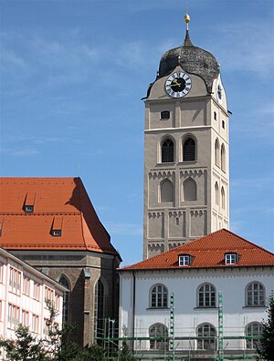
Erding
Town in Bavaria, Germany
Distance: Approx. 3558 meters
Latitude and longitude: 48.28333333,11.9
Erding (German pronunciation: [ˈeːɐ̯dɪŋ] ) is a town in Bavaria, Germany, and capital of the rural district of the same name. It had a population of 36,469 in 2019. The original Erdinger Weissbier is a well-known Bavarian specialty.
Erdinger
German brewery
Distance: Approx. 1434 meters
Latitude and longitude: 48.30666667,11.90722222
The Privatbrauerei Erdinger Weißbräu Werner Brombach GmbH (also known as Erdinger Weißbräu) is a brewery in Erding, Germany. Its best-known products are its namesake Weißbiers (wheat beer).
Erding Air Base
Airport in Erding, Germany
Distance: Approx. 2167 meters
Latitude and longitude: 48.3225,11.94861111
Erding Air Base (German: Fliegerhorst Erding, ICAO: ETSE) is a German Air Force airfield near the town of Erding, about 45 kilometers (28 mi) northeast of central Munich in Bavaria. It is the home of the 5th Air Defense Missile Squadron and the 1st Air Force Maintenance Regiment. The last public airshow at Erding was held during the summer of 1986.

Bockhorn, Bavaria
Municipality in Bavaria, Germany
Distance: Approx. 4318 meters
Latitude and longitude: 48.31666667,11.98333333
Bockhorn is a municipality in the district of Erding in Bavaria in Germany.

Moosinning
Municipality in Bavaria, Germany
Distance: Approx. 6366 meters
Latitude and longitude: 48.28333333,11.85
Moosinning is a municipality in the district of Erding in Bavaria in Germany.

Oberding
Municipality in Bavaria, Germany
Distance: Approx. 5656 meters
Latitude and longitude: 48.31666667,11.85
Oberding (German: Oberding, Bavarian: Obading) is a municipality in the district of Erding in Upper Bavaria in Germany, and member of the same administrative community. Almost half of the area of Munich Airport, including both terminals, falls within the municipal bounds.

Therme Erding
Largest thermal bath complex in Europe
Distance: Approx. 3656 meters
Latitude and longitude: 48.29027778,11.88666667
Therme Erding is the largest thermal bath complex in Europe. It is 30 minutes northeast of Munich by car and is visited by around 5,000 people every day.

University of Applied Management
Distance: Approx. 1166 meters
Latitude and longitude: 48.3043,11.9129
Established in 2004, the University of Applied Management (UAM) is a private, state-approved and fee-based university in Bavaria. The headquarters is located in Ismaning. The for-profit university also has campuses in Neumarkt, Berlin, Treuchtlingen, Unna and Accra.

Erding station
Munich S-Bahn station
Distance: Approx. 1272 meters
Latitude and longitude: 48.3034,11.9121
Erding station is a railway station on the Munich S-Bahn in the town of Erding in the northeast area of Munich, Germany. It is served by the S-Bahn line S2.
Altenerding station
Munich S-Bahn station
Distance: Approx. 2564 meters
Latitude and longitude: 48.2937,11.9018
Altenerding station is a railway station in the Altenerding district of the municipality of Erding, located in the Erding district in Upper Bavaria, Germany.
Aufhausen (bei Erding) station
Munich S-Bahn station
Distance: Approx. 4628 meters
Latitude and longitude: 48.2744,11.8943
Aufhausen (bei Erding) station is a railway station in the Aufhausen district of the municipality of Erding, located in the Erding district in Upper Bavaria, Germany.
Weather in this IP's area
fog
15 Celsius
15 Celsius
14 Celsius
17 Celsius
1012 hPa
97 %
1012 hPa
958 hPa
10000 meters
0.51 m/s
8 %
06:40:00
19:40:09