Country:
Region:
City:
Latitude and Longitude:
Time Zone:
Postal Code:
IP information under different IP Channel
ip-api
Country
Region
City
ASN
Time Zone
ISP
Blacklist
Proxy
Latitude
Longitude
Postal
Route
Luminati
Country
Region
sp
City
santabarbaradoeste
ASN
Time Zone
America/Sao_Paulo
ISP
America-NET Ltda.
Latitude
Longitude
Postal
IPinfo
Country
Region
City
ASN
Time Zone
ISP
Blacklist
Proxy
Latitude
Longitude
Postal
Route
db-ip
Country
Region
City
ASN
Time Zone
ISP
Blacklist
Proxy
Latitude
Longitude
Postal
Route
ipdata
Country
Region
City
ASN
Time Zone
ISP
Blacklist
Proxy
Latitude
Longitude
Postal
Route
Popular places and events near this IP address
Santa Bárbara d'Oeste
Place in São Paulo, Brazil
Distance: Approx. 5292 meters
Latitude and longitude: -22.75444444,-47.41416667
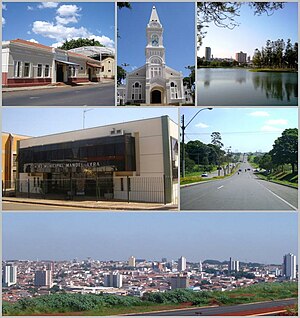
Santa Bárbara d'Oeste is a municipality in the State of São Paulo in Brazil. It is part of the Metropolitan Region of Campinas. It lies about 138 kilometres (86 mi) northwest of the State capital.

Estádio Antônio Lins Ribeiro Guimarães
Distance: Approx. 4750 meters
Latitude and longitude: -22.755475,-47.42447778
Estádio Antônio Lins Ribeiro Guimarães is a multi-use stadium located in Santa Bárbara d'Oeste, Brazil. It is used mostly for football matches and hosts the home matches of União Agrícola Barbarense Futebol Clube. The stadium has a maximum capacity of 15,000 people and was built in 1921.
Weather in this IP's area
overcast clouds
21 Celsius
22 Celsius
21 Celsius
21 Celsius
1014 hPa
90 %
1014 hPa
947 hPa
10000 meters
2.59 m/s
5.43 m/s
22 degree
99 %
05:21:41
18:25:09
