170.82.114.220 - IP Lookup: Free IP Address Lookup, Postal Code Lookup, IP Location Lookup, IP ASN, Public IP
Country:
Region:
City:
Location:
Time Zone:
Postal Code:
ISP:
ASN:
language:
User-Agent:
Proxy IP:
Blacklist:
IP information under different IP Channel
ip-api
Country
Region
City
ASN
Time Zone
ISP
Blacklist
Proxy
Latitude
Longitude
Postal
Route
db-ip
Country
Region
City
ASN
Time Zone
ISP
Blacklist
Proxy
Latitude
Longitude
Postal
Route
IPinfo
Country
Region
City
ASN
Time Zone
ISP
Blacklist
Proxy
Latitude
Longitude
Postal
Route
IP2Location
170.82.114.220Country
Region
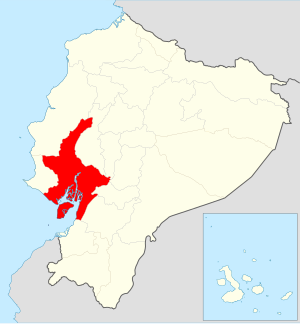
guayas
City
guayaquil
Time Zone
America/Guayaquil
ISP
Language
User-Agent
Latitude
Longitude
Postal
ipdata
Country
Region
City
ASN
Time Zone
ISP
Blacklist
Proxy
Latitude
Longitude
Postal
Route
Popular places and events near this IP address

José Joaquín de Olmedo International Airport
Ecuatorian airport serving Guayaquil
Distance: Approx. 2070 meters
Latitude and longitude: -2.1575,-79.88361111
José Joaquín de Olmedo International Airport (Spanish: Aeropuerto Internacional José Joaquín de Olmedo; IATA: GYE, ICAO: SEGU) is an international airport serving Guayaquil, the capital of the Guayas Province and the most populous city in Ecuador. It is the second busiest airport in Ecuador. The airport was named after José Joaquín de Olmedo, a notable Ecuadorian poet, first mayor of Guayaquil, and former president of Ecuador.
Tarqui, Guayaquil Canton
Distance: Approx. 1838 meters
Latitude and longitude: -2.15346,-79.91039
Tarqui is an urban parish in Guayaquil Canton, Guayas, Ecuador, named after the Battle of Tarqui. Tarqui is the largest and most populous parish in Guayaquil. It occupies the northern half of the city.

Estadio Modelo Alberto Spencer Herrera
Distance: Approx. 1532 meters
Latitude and longitude: -2.17886111,-79.89436944
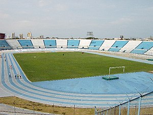
Estadio Modelo Alberto Spencer, also known as just Estadio Modelo, is a multi-purpose stadium in Guayaquil, Ecuador. It is currently used mostly for association football matches and it sometimes hosts games of Rocafuerte Fútbol Club, Club 9 de Octubre, Club Sport Patria, Club Deportivo Everest, Calvi Fútbol Club, Panamá Sporting Club and Club Sport Norteamérica. The stadium holds 42,000, and was opened in July 1959.

Guayaquil Ecuador Temple
LDS Church temple in Guayaquil, Ecuador
Distance: Approx. 1244 meters
Latitude and longitude: -2.156246,-79.904877
The Guayaquil Ecuador Temple is the 58th operating temple of the Church of Jesus Christ of Latter-day Saints (LDS Church).

Simón Bolívar Canton
Canton in Guayas Province, Ecuador
Distance: Approx. 1756 meters
Latitude and longitude: -2.15666667,-79.8875
Simón Bolívar Canton is a canton of Ecuador, located in the Guayas Province. Its capital is the town of Simón Bolívar. Its population at the 2001 census was 20,385.
Mapasingue
Neighbourhood of Guayaquil, Ecuador
Distance: Approx. 1808 meters
Latitude and longitude: -2.15006,-79.89984
Mapasingue is a barrio (neighborhood) of the city of Guayaquil, Ecuador.

University of Guayaquil
Distance: Approx. 1962 meters
Latitude and longitude: -2.18341,-79.89576
The University of Guayaquil (Spanish: Universidad de Guayaquil), known colloquially as the Estatal (i.e., "the State [University]"), is a public university in Guayaquil, Guayas Province, Ecuador. Estatal was founded in 1883. It is the oldest university in the city of Guayaquil and has the largest student body (over 80,000 students).
Universidad Católica de Santiago de Guayaquil
Distance: Approx. 1764 meters
Latitude and longitude: -2.18166667,-79.90388889
Universidad Católica de Santiago de Guayaquil (UCSG) (English: Catholic University of Santiago de Guayaquil) is a private, Catholic, higher education institution in Ecuador.
Presley Norton Museum
Distance: Approx. 2426 meters
Latitude and longitude: -2.1876,-79.8954
The Presley Norton Museum (Museo Presley Norton) is a museum in Guayaquil, Ecuador which houses a collection of archaeological artifacts, including pottery and figurines made by the original settlers of Ecuador. It occasionally hosts film screenings and live music. The museum has approximately 8,000 artifacts, some dating as far back as 3000 B.C. The museum is in the Villa Rosa Herlinda mansion, once owned by Ismael Pérez Pazmiño, the founder of El Universo newspaper.

Velero Bridge
Distance: Approx. 2518 meters
Latitude and longitude: -2.18888889,-79.90111111
Velero Bridge, also known as "El Velero", (Spanish: Puente del Velero) is a bridge in Guayaquil, Ecuador. One of the prominent landmarks of the city, especially when lit up at night, it was inaugurated on July 27, 2005. It forms part of the route of the Guayaquil Marathon.

Universidad Estatal Península de Santa Elena
Public university of Ecuador
Distance: Approx. 1962 meters
Latitude and longitude: -2.18341,-79.89576
The State University Santa Elena Peninsula (Spanish: Universidad Estatal Península de Santa Elena, - literal translation: State University Santa Elena Peninsula, UPSE) is a public university located in the canton freedom of the province of Santa Elena in the Republic of Ecuador, is the first autonomous center of teaching and which has the largest student population in the area.

Centro Comercial Albán Borja
Shopping mall in Guayaquil, Ecuador
Distance: Approx. 1858 meters
Latitude and longitude: -2.16852186,-79.91655749
Centro Comercial Albán Borja is a shopping mall located in Guayaquil, Ecuador. It was inaugurated on 10 March 1983, and its named after Colonel Agustín Albán Borja of the navy; its architecture is based on hexagonal shapes which makes many of the people who visit the shopping center become disoriented, due to the shape of a 8 with seven points makes the food court triangular in shape. With a construction area of 72,000 m2, capacity for 800 vehicles, 130 commercial premises, it is, together with the Policentro, the first two shopping centers in the city of the 80s.
Weather in this IP's area
broken clouds
25 Celsius
26 Celsius
25 Celsius
25 Celsius
1014 hPa
78 %
1014 hPa
1013 hPa
10000 meters
2.06 m/s
200 degree
75 %
