170.61.187.179 - IP Lookup: Free IP Address Lookup, Postal Code Lookup, IP Location Lookup, IP ASN, Public IP
Country:
Region:
City:
Location:
Time Zone:
Postal Code:
IP information under different IP Channel
ip-api
Country
Region
City
ASN
Time Zone
ISP
Blacklist
Proxy
Latitude
Longitude
Postal
Route
Luminati
Country
ASN
Time Zone
America/Chicago
ISP
THE-BANK-OF-NEW-YORK-MELLON-CORPORATION-AS11911
Latitude
Longitude
Postal
IPinfo
Country
Region
City
ASN
Time Zone
ISP
Blacklist
Proxy
Latitude
Longitude
Postal
Route
IP2Location
170.61.187.179Country
Region
new york
City
new york city
Time Zone
America/New_York
ISP
Language
User-Agent
Latitude
Longitude
Postal
db-ip
Country
Region
City
ASN
Time Zone
ISP
Blacklist
Proxy
Latitude
Longitude
Postal
Route
ipdata
Country
Region
City
ASN
Time Zone
ISP
Blacklist
Proxy
Latitude
Longitude
Postal
Route
Popular places and events near this IP address
Drexel Burnham Lambert
Former American investment bank
Distance: Approx. 23 meters
Latitude and longitude: 40.70536,-74.01198
Drexel Burnham Lambert Inc. was an American multinational investment bank that was forced into bankruptcy in 1990 due to its involvement in illegal activities in the junk bond market, driven by senior executive Michael Milken. At its height, it was a Bulge Bracket bank, as the fifth-largest investment bank in the United States.

Broad Street (Manhattan)
Street in Manhattan, New York
Distance: Approx. 28 meters
Latitude and longitude: 40.705,-74.0116
Broad Street is a north–south street in the Financial District of Lower Manhattan in New York City. Originally the Broad Canal in New Amsterdam, it stretches from today's South Street to Wall Street. The canal drew its water from the East River, and was infilled in 1676 after numerous fruit and vegetable vendors made it difficult for boats to enter the canal.

Millennium High School (New York City)
Public school in New York City
Distance: Approx. 73 meters
Latitude and longitude: 40.704606,-74.011444
Millennium High School is a selective public high school for grades 9 through 12 in Manhattan. It is operated by the New York City Department of Education in Region 9. The Phoenix is the school's mascot, meant to symbolize the school rising from the ashes of the World Trade Center following the September 11 attacks.
Continental Bank Building
Office skyscraper in Manhattan, New York
Distance: Approx. 103 meters
Latitude and longitude: 40.70610833,-74.01154444
The Continental Bank Building is a 50-story skyscraper at 30 Broad Street in the Financial District of Manhattan, New York City. It was completed in 1932 in the Art Deco style. It is next to the New York Stock Exchange Building.
American Bank Note Company Building
Building in Manhattan, New York
Distance: Approx. 45 meters
Latitude and longitude: 40.7048,-74.0117
The American Bank Note Company Building is a five-story building at 70 Broad Street in the Financial District of Manhattan in New York City. The building was designed by architects Kirby, Petit & Green in the neo-classical style, and contains almost 20,000 square feet (1,900 m2) of space, with offices and residences on the upper floors. The exterior consists of a main facade on Broad Street with two columns, as well as side facades with pilasters on Beaver and Marketfield Streets.
Broad Exchange Building
Residential building in Manhattan, New York
Distance: Approx. 79 meters
Latitude and longitude: 40.70583333,-74.01138889
The Broad Exchange Building, also known as 25 Broad Street, is a residential building at Exchange Place and Broad Street in the Financial District of Lower Manhattan in New York City. The 20-story building was designed by Clinton & Russell and built between 1900 and 1902. The Alliance Realty Company developed the Broad Exchange Building as a speculative development for office tenants.
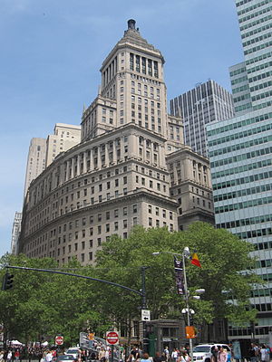
26 Broadway
Office skyscraper in Manhattan, New York
Distance: Approx. 113 meters
Latitude and longitude: 40.70555556,-74.01305556
26 Broadway, also known as the Standard Oil Building or Socony–Vacuum Building, is an office building adjacent to Bowling Green in the Financial District of Lower Manhattan in New York City. The 31-story, 520-foot-tall (160 m) structure was designed in the Renaissance Revival style by Thomas Hastings of Carrère and Hastings, in conjunction with Shreve, Lamb & Blake. It was built in 1884–1885 as the headquarters of Standard Oil, at the time one of the largest oil companies in the United States, and expanded to its current size in 1921–1928.

Lee, Higginson & Company Bank Building
Historic commercial building in New York, United States
Distance: Approx. 53 meters
Latitude and longitude: 40.70555556,-74.01138889
The Lee, Higginson & Company Bank Building is a historic bank building located at 41 Broad Street in the Financial District of Lower Manhattan, New York City. The structure was designed by architects Cross & Cross and built in 1928–1929. It is a 10-story, Classical Revival style, with a top floor penthouse.

Léman Manhattan Preparatory School
School in New York, United States
Distance: Approx. 89 meters
Latitude and longitude: 40.7058,-74.0111
Léman Manhattan Preparatory School is a private school located in the Financial District, Manhattan. Students are ages two years old through eighteen years old. There are two Lower Manhattan sites.

Marketfield Street
Street in Manhattan, New York
Distance: Approx. 89 meters
Latitude and longitude: 40.704648,-74.012568
Marketfield Street is a short one-way, one-block-long alleyway in the Financial District of Manhattan, New York City. The street begins as a southern branch of Beaver Street, then veers east and north, ending at Broad Street. Alternative past names include Exchange Street, Field Street, Fieldmarket Street, Oblique Road, and Petticoat Lane.
45 Broad Street
Planned residential building in Manhattan, New York
Distance: Approx. 53 meters
Latitude and longitude: 40.70555556,-74.01138889
45 Broad Street is a residential building being constructed in the Financial District of Manhattan in New York City. The building was originally planned as Lower Manhattan's tallest residential tower. Excavation started in 2017, but as of 2020, construction is on hold.

55 Broad Street
Building in Manhattan, New York
Distance: Approx. 59 meters
Latitude and longitude: 40.70527778,-74.01111111
55 Broad Street is a 30-story building at Broad Street and Beaver Street in the Financial District of Manhattan in New York City, New York. It adjoins 15 William, a skyscraper to the east. The building was constructed from 1964 to 1967, and initially operated as the headquarters of the trading firm Goldman Sachs from 1967 to 1983.
Weather in this IP's area
clear sky
-0 Celsius
-7 Celsius
-2 Celsius
0 Celsius
1008 hPa
61 %
1008 hPa
1007 hPa
10000 meters
7.72 m/s
12.35 m/s
320 degree


