Country:
 Uruguay
Region:
City:
Latitude and Longitude:
Time Zone:
Postal Code:
IP information under different IP Channel
ip-api
Country
Region
City
ASN
Time Zone
ISP
Blacklist
Proxy
Latitude
Longitude
Postal
Route
IPinfo
Country
Region
City
ASN
Time Zone
ISP
Blacklist
Proxy
Latitude
Longitude
Postal
Route
MaxMind
Country
Region
City
ASN
Time Zone
ISP
Blacklist
Proxy
Latitude
Longitude
Postal
Route
Luminati
Country
 PY
PYRegion
asu
City
asuncion
ASN
Time Zone
America/Asuncion
ISP
Techtel LMDS Comunicaciones Interactivas S.A.
Latitude
Longitude
Postal
db-ip
Country
Region
City
ASN
Time Zone
ISP
Blacklist
Proxy
Latitude
Longitude
Postal
Route
ipdata
Country
Region
City
ASN
Time Zone
ISP
Blacklist
Proxy
Latitude
Longitude
Postal
Route
Popular places and events near this IP address

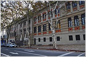
University of the Republic (Uruguay)
Uruguayan public university
Distance: Approx. 1122 meters
Latitude and longitude: -34.9025,-56.17666667
The University of the Republic (Spanish: Universidad de la República, sometimes UdelaR) is a public research university in Montevideo, Uruguay. It is the oldest and largest university in the country, as well as the second largest public university in South America and the world's 57th largest by enrollment, with a student body of 137,757 undergraduate students in 2018 and 6,351 postgraduate students in 2012. It was founded on 18 July 1849 in Montevideo, where most of its buildings and facilities are still located.

Estadio Pocitos
Distance: Approx. 880 meters
Latitude and longitude: -34.905,-56.15611111
Estadio Pocitos was a multi-use stadium located in the Pocitos district of Montevideo, Uruguay. The stadium, owned by C.A. Peñarol, was mainly used for football matches from 1921 to 1933. It was demolished later in the 1930s when Peñarol started to play in the Estadio Centenario as its home field, and additionally due to the increasing urbanisation of Montevideo.

Parque Luis Méndez Piana
Distance: Approx. 1124 meters
Latitude and longitude: -34.89686944,-56.15331667
Parque Luis Méndez Piana is a multi-use stadium in Montevideo, Uruguay. It is currently used primarily for football matches and is the home stadium of Miramar Misiones. The stadium holds 4,000 people.

Parque Palermo
Distance: Approx. 1062 meters
Latitude and longitude: -34.89786389,-56.15355556
Parque Palermo is a multi-use stadium in Montevideo, Uruguay. It is currently used primarily for football matches and is the home stadium of Central Español. The stadium holds 6,500 spectators.
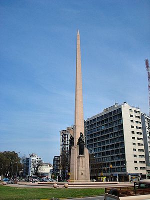
Obelisk of Montevideo
Distance: Approx. 401 meters
Latitude and longitude: -34.8975,-56.1644
The Obelisk of Montevideo, officially Obelisk to the Constituents of 1830 (Spanish: Obelisco a los Constituyentes de 1830) is a monument created by sculptor José Luis Zorrilla de San Martín (1891-1975). It is a three-sided obelisk made of granite, 40 metres (130 ft) tall with three bronze statues on its sides, representing "Law", "Liberty" and "Force". It has a hexagonal water fountain around it with six spheres on its outer circumference.

Tres Cruces
Barrio in Montevideo Department, Uruguay
Distance: Approx. 670 meters
Latitude and longitude: -34.89583333,-56.16805556
Tres Cruces is a barrio (neighbourhood or district) of Uruguay's capital Montevideo. Its name means "three crossings", referring to the three major transportation routes which intersect in the area: Avenida 18 de Julio, Bulevar Artigas and Avenida 8 de Octubre. It is also the starting point of Italia Avenue.
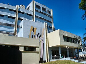
Hospital Pereira Rossell
Hospital in Montevideo, Uruguay
Distance: Approx. 348 meters
Latitude and longitude: -34.89805556,-56.16361111
Hospital Pereira Rossell is a hospital in Montevideo, Uruguay. It is located in the barrio Parque Batlle, just west of the park of the same name. It was founded in 1908 and was built on land donated in late 1900 by Alexis Rossell y Rius and Dolores Pereira de Rossell.

British Hospital (Montevideo)
Hospital in Montevideo, Uruguay
Distance: Approx. 733 meters
Latitude and longitude: -34.89472222,-56.1625
The British Hospital or Hospital Británico is a private hospital in Montevideo, Uruguay. It is located in the barrio of Parque Batlle, just west of the park of the same name.

Italian Hospital of Montevideo
Hospital in Montevideo, Uruguay
Distance: Approx. 556 meters
Latitude and longitude: -34.89611111,-56.16416667
The Italian Hospital of Montevideo, whose official name is Ospedale italiano Umberto I, (Spanish: Hospital Italiano de Montevideo) is a clinic and sanatorium founded in 1890 near Parque Batlle, Montevideo. It lies just to the north of the 1830 obelisk and the Hospital Pereira Rossell. The building, of the late neoclassical style, is the work of architect Luis Andreoni.

Pista de Atletismo Darwin Piñeyrúa
Distance: Approx. 892 meters
Latitude and longitude: -34.8956,-56.1574
Pista de Atletismo Darwin Piñeyrúa is a running track in Montevideo, Uruguay. It is a major venue for events organized by the Uruguayan Athletics Confederation. It is situated in the Parque Batlle near Estadio Centenario.

German School of Montevideo
Private, bilingual school in Montevideo, Uruguay
Distance: Approx. 944 meters
Latitude and longitude: -34.9048,-56.1552
Colegio y Liceo Alemán de Montevideo (formal Spanish name). (English: German School of Montevideo) is one of the most prestigious schools in Uruguay. It was established in 1857 for the children of German traders, artists, engineers and diplomats living in Montevideo.
Alfredo Vásquez Acevedo Institute
Public secondary school in Cordón, Montevideo, Uruguay
Distance: Approx. 1080 meters
Latitude and longitude: -34.9037,-56.1759
The Instituto Alfredo Vásquez Acevedo (Spanish for 'Alfredo Vásquez Acevedo Institute') known by its acronym IAVA, is a public high school in Montevideo, Uruguay. Identified as Liceo No. 35 of Montevideo, it was named in honor of the jurist and politician Alfredo Vásquez Acevedo.
Weather in this IP's area
clear sky
8 Celsius
8 Celsius
8 Celsius
8 Celsius
1024 hPa
87 %
1024 hPa
1018 hPa
10000 meters
06:42:09
18:36:46